
National Register of Historic Places listings in St. Francis County, Arkansas facts for kids

Have you ever wondered about the old buildings and special places in your community? Many places in the United States have a rich history, and some are so important that they are added to a special list called the National Register of Historic Places. This list helps protect and celebrate these unique spots.
This article is all about the historic places in St. Francis County, Arkansas, that are on this important list. There are 14 of these special properties in the county. Each one has a story to tell about the past!
Contents
What is the National Register of Historic Places?
The National Register of Historic Places is the official list of the nation's historic places worth saving. It's like a hall of fame for buildings, sites, structures, objects, and districts that are important to American history, architecture, archaeology, engineering, or culture. When a place is added to this list, it means it's recognized for its special value. This helps people understand why these places are important and encourages their preservation for future generations.
Historic Places in St. Francis County
St. Francis County has many interesting places that tell us about its past. Here are some of the sites listed on the National Register of Historic Places:
Important Historical Sites
Blackfish Lake Ferry Site
This site is located near New Shady Grove, Arkansas. It's a significant spot because it's connected to the Trail of Tears. The Trail of Tears was a very difficult time in American history when many Native American people were forced to move from their homes. This site helps us remember that important part of the past. It was added to the Register in 2003.
Scott Bond Family Plot
Found near Madison, Arkansas, this family plot is a historic burial ground. It was added to the Register in 2002.
Historic Buildings and Homes
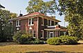
Campbell House
The Campbell House is a beautiful old home located at 305 North Forrest Street in Forrest City, Arkansas. It was recognized for its historical importance in 2006.
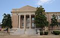
First United Methodist Church
Also in Forrest City, Arkansas, this church at 101 South Izard Street is a significant building. It was added to the Register in 1994, showing its long history in the community.
Forrest City High School
The old Forrest City High School building on Rosser Street in Forrest City, Arkansas, is another historic site. It was listed in 1992, reminding us of the history of education in the area.
Mann House
Located at 422 Forest Street in Forrest City, Arkansas, the Mann House is an important historic residence. It was added to the Register in 1982.
Smith House
The Smith House on Memphis Avenue in Wheatley, Arkansas, is another historic home on the list. It was recognized in 1982.
William Stone House
This house is found at the corner of Highway 306 and Doris Lane in Colt, Arkansas. It was added to the Register in 1992.
Bridges and Structures
Highway B-1, Little Telico Creek Bridge
This bridge crosses Little Telico Creek on SFC 213 Road near Caldwell, Arkansas. Bridges are often important for their engineering and how they helped people travel. This one was listed in 2009.
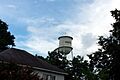
Hughes Water Tower
The water tower on Church Street in Hughes, Arkansas, is a notable structure. Water towers are often landmarks and important for a town's infrastructure. This one was added to the Register in 2006.
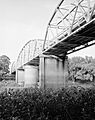
St. Francis River Bridge
This bridge carries U.S. Route 70 over the St. Francis River near Madison, Arkansas. Bridges like this are vital for transportation and can be impressive feats of engineering. It was listed in 1990.
Other Notable Sites
Stuart Springs
Stuart Springs is located on Stuart Street in Forrest City, Arkansas. Natural springs can be important historical sites, sometimes used for water, recreation, or as gathering places. This site was added to the Register in 1977.
Images for kids
-
The historic Campbell House in Forrest City.
-
The First United Methodist Church in Forrest City.
-
The Hughes Water Tower.
-
The St. Francis River Bridge near Madison.


