
National Register of Historic Places listings in St. Francois County, Missouri facts for kids

Have you ever wondered about old buildings or places that have a special story? In the United States, there's a list called the National Register of Historic Places. It helps protect important buildings, sites, and objects that are part of our country's history. These places show us how people lived, worked, and built communities long ago.
St. Francois County, Missouri is home to many such special places. These sites are recognized because they are important to the history of Missouri and the entire country. Let's explore some of these amazing historic spots in St. Francois County!
Contents
Historic Places in St. Francois County
St. Francois County has 11 different properties and areas listed on the National Register. Each one tells a unique part of the county's past.
Bonne Terre Depot
The Bonne Terre Depot is an old train station located on Oak Street in Bonne Terre. It was added to the National Register in 1984. Train depots were once very busy places. They were where people traveled from and to, and where goods were shipped. This depot reminds us of a time when trains were a main way to get around.

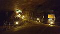
Bonne Terre Mine
Also in Bonne Terre is the famous Bonne Terre Mine. This mine was listed on the National Register in 1974. It was once one of the largest lead mines in the world! Lead mining was a huge industry in this part of Missouri. The mine helped the town of Bonne Terre grow. Today, parts of the mine are open for tours. You can even go scuba diving in its flooded tunnels!

Farmington's Historic Districts
The city of Farmington has several areas known as historic districts. These are groups of buildings that together tell a story about the past.
Courthouse Square Historic District
The Courthouse Square Historic District in Farmington was added to the list in 2004. This area includes the St. Francois County Courthouse. Courthouses are important buildings where local government decisions are made. This district shows how the town center developed over time.

East Columbia Historic District
The East Columbia Historic District in Farmington is another important area. It was recognized in 2004. This district includes many historic homes and buildings along East Columbia Street. Walking through this area is like taking a step back in time. You can see different styles of architecture from long ago.

Other Notable Farmington Sites
Farmington is home to other unique historic places.
James Robinson McCormick House
The James Robinson McCormick House is a historic home located on West Columbia Street. It was listed in 1998. This house was once the home of James Robinson McCormick, an important person in the community's history. Historic homes often show us how people lived and what their lives were like in the past.

Presbyterian Orphanage of Missouri
The Presbyterian Orphanage of Missouri is another significant site in Farmington. It was added to the National Register in 2006. Located on West Liberty Street, this building once served as a home for children who needed care. It represents an important part of social history and how communities cared for their most vulnerable members.

St. Francois County Jail and Sheriff's Residence
The St. Francois County Jail and Sheriff's Residence is a unique historic building on North Franklin Street. It was listed in 1996. This building served as both the county jail and the home for the sheriff. It gives us a glimpse into the history of law enforcement in the county.

Historic Places in Park Hills
The city of Park Hills also has its share of historic properties.
Eugene Field School
The Eugene Field School in Park Hills was added to the National Register in 2005. Located on Glendale Street, this old school building reminds us of the history of education in the area. Schools are often central to a community's development.
Howlett Gulf
The Howlett Gulf building on East Main Street in Park Hills was listed in 2019. While its specific history isn't detailed here, many historic commercial buildings like this one were once important shops or businesses that served the local community.
St. Joe Lead Company Administration Building
Back in Bonne Terre, the St. Joe Lead Company Administration Building on Elm Street was listed in 1984. This building was the main office for the St. Joe Lead Company, which operated the famous Bonne Terre Mine. It was where important decisions about the mining operations were made. This building is a key part of the region's mining heritage.
Images for kids
-
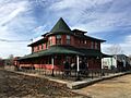
The historic Bonne Terre Depot.
-
An old photo showing the Bonne Terre Mine and town.
-
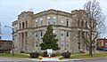
The St. Francois County Courthouse in Farmington.
-
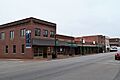
Historic buildings in the East Columbia Historic District.
-
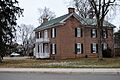
The James Robinson McCormick House.
-

The former Presbyterian Orphanage of Missouri building.
-
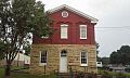
The front of the St. Francois County Jail and Sheriff's Residence.
