
National Register of Historic Places listings in Tangipahoa Parish, Louisiana facts for kids

Welcome to Tangipahoa Parish, Louisiana! This area is home to many special places that are listed on the National Register of Historic Places. Think of this register as a national "hall of fame" for buildings, sites, and objects that are important to American history, architecture, or culture. These places are protected and celebrated so future generations can learn from them.
In Tangipahoa Parish, there are 32 different properties and areas on this important list. Five other places were once listed but have since been removed. Let's explore some of these fascinating historical treasures!
Contents
Historic Gems of Tangipahoa Parish
Tangipahoa Parish is full of interesting old buildings and sites. Each one tells a unique story about the past.
Camp Moore: A Civil War Landmark

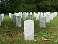
One of the most important historical sites in Tangipahoa Parish is Camp Moore. This camp, located near Tangipahoa, was a major training camp for Confederate soldiers during the American Civil War. Thousands of young men from Louisiana and other Southern states came here to train before heading off to battle.
Camp Moore was established in 1861 and became the largest Confederate training camp in Louisiana. It was named after Governor Thomas Overton Moore. Today, Camp Moore is a museum and a cemetery, honoring the soldiers who trained and died there. It's a powerful reminder of a difficult time in American history.
Beautiful Old Churches
Tangipahoa Parish has several historic churches that are still standing today. These buildings often show beautiful old architectural styles.
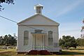
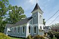
Arcola Presbyterian Church

The Arcola Presbyterian Church in Arcola is a lovely example of a historic church. It was built in 1853 and has been a central part of the community for over 170 years. Its simple yet elegant design reflects the style of churches built in the South during that time.
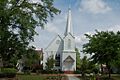
Episcopal Church of the Incarnation

In Amite City, you can find the Episcopal Church of the Incarnation. This church, built in 1870, is known for its Gothic Revival style, which includes pointed arches and stained-glass windows. It has served its community for many years and remains a significant landmark.
Grand Old Homes
Many historic homes in Tangipahoa Parish offer a glimpse into how people lived long ago.
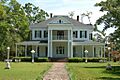
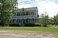
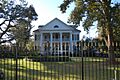
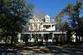
Blythewood

Blythewood is a beautiful historic home located in Amite City. Built in 1850, it's a great example of Greek Revival architecture, which was popular in the Southern United States. Imagine what life was like in this grand house over 170 years ago!
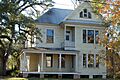
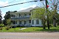
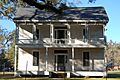
Green Shutters

The Green Shutters house in Tangipahoa is another charming historic residence. Built in 1880, it features classic Southern architectural elements, including its distinctive green shutters that give the house its name.
Historic School Buildings
Education has always been important in Tangipahoa Parish, and some of its old school buildings are now historic landmarks.
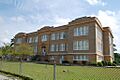
Old Hammond High School

The building known as Old Hammond High School in Hammond was built in 1928. It served as the main high school for many years. Even though the school moved to a new location, this old building remains an important part of Hammond's history. It shows the architectural style of schools built in the early 20th century.
McGehee Hall, Southeastern Louisiana University

At Southeastern Louisiana University in Hammond, you'll find McGehee Hall. This building, constructed in 1925, is the oldest on the university's main campus. It has seen countless students pass through its doors and is a symbol of the university's long history.
Tangipahoa School

The Tangipahoa School building in Tangipahoa was built in 1938. It's a great example of the school architecture of its time, designed to serve the educational needs of the community.
Historic Districts: A Collection of History
Sometimes, it's not just one building that's historic, but a whole area! These are called historic districts.
Hammond Historic District

The Hammond Historic District covers a large part of downtown Hammond. This area is special because it has many old buildings, shops, and homes that together tell the story of how Hammond grew and developed. Walking through this district is like taking a step back in time!
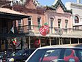
Ponchatoula Commercial Historic District

The Ponchatoula Commercial Historic District in Ponchatoula includes many of the old businesses and buildings in the heart of the town. These buildings show the history of commerce and community life in Ponchatoula, especially its famous strawberry industry.
Former Listings
Some properties were once on the National Register of Historic Places but have since been removed. This can happen if a building is moved, changed too much, or even destroyed. For example, the Pass Manchac Light, an old lighthouse near Ponchatoula, was once listed but was unfortunately destroyed by Hurricane Isaac (2012) in 2012.
These historic places in Tangipahoa Parish help us understand the past and appreciate the rich heritage of Louisiana.
Images for kids
-
Arcola Presbyterian Church
-
Blythewood
-
Camp Moore
-
Cate House
-
Episcopal Church of the Incarnation
-
Grace Memorial Episcopal Church
-
Green Shutters
-
Greenlawn
-
Old Hammond High School
-

Hammond Historic District
-

Charles Adolph Kent, Sr., House
-

McGehee Hall, Southeastern Louisiana University
-
McGehee House
-
G. W. Nesom House
-
Ponchatoula Commercial Historic District
-
Randal House
-
Stevenson House
-
Tangipahoa School


