
National Register of Historic Places listings in Tate County, Mississippi facts for kids

Imagine a special list that helps protect old buildings, places, and even whole neighborhoods that are important to history! That's kind of what the National Register of Historic Places is. It's America's official list of places that are worth saving because of their history, architecture, or what happened there. When a place is on this list, it means it's recognized as a valuable part of our past.
This article shares a list of these special places found in Tate County, Mississippi, United States. There are 10 properties and areas in Tate County that are currently on this important list. Knowing where these places are helps us appreciate and protect them.
What is the National Register of Historic Places?
The National Register of Historic Places is like a hall of fame for historic sites across the United States. It's managed by the National Park Service. Its main goal is to encourage people to save and protect places that tell important stories about our country's past.
When a building or area is added to the National Register, it gets special recognition. This recognition can help protect it from being torn down or changed too much. It also helps people learn about the history of their community. These places can be anything from old houses and schools to bridges and entire neighborhoods.
Historic Places in Tate County
Tate County has several places listed on the National Register. Most of these are in the city of Senatobia. These listings help us remember and celebrate the history of the area.
Senatobia's Special Spots
Many of the historic places in Tate County are actually entire neighborhoods or areas in Senatobia. These are called "historic districts." A historic district is a group of buildings, usually in a town or city, that are important together because of their history or how they look.
- College Street Historic District: This area includes several streets like College Street, North Center, and West Main. It was added to the list in 1994.
- Downtown Senatobia Historic District: This district covers the heart of Senatobia, including parts of North and South Center Streets and West Main Street. It was also listed in 1994. This area shows what the town center looked like long ago.
- North Panola Street Historic District: Found along North Panola Street, this district was recognized in 1994.
- North Park Street Historic District: This area on North Park Street was added to the list in 1994.
- South Panola Street Historic District: Located on South Panola Street, this district joined the list in 1994.
- South Ward Street Historic District: This district includes parts of Church, West Gilmore, and South Ward Streets. It was listed in 1994.
- Southeast Senatobia Historic District: This larger area covers parts of South Park, East Gilmore, and East Tate Streets. It was added in 1994.
These historic districts help preserve the unique look and feel of Senatobia's past. They show how the town grew and developed over time.
Other Important Places
Besides the historic districts, Tate County also has individual buildings and properties on the National Register.
- McGehee Plantation: Located on Ed Nelson Drive in Senatobia, this plantation was added to the list in 2007. Plantations are large farms that were common in the Southern United States long ago.
- Tate County Agricultural High School Historic District: This district is centered around 510 North Panola Street. It was listed in 1994. Agricultural high schools were important for teaching farming skills to young people.
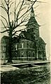
- Tate County Courthouse: The courthouse, located at 201 South Ward Street, was added to the list in 1994. Courthouses are often important buildings in a county, where local government and legal matters take place.
Why Do We Protect These Places?
Protecting historic places is important for many reasons. They help us understand where we came from and how our communities have changed. They can also be beautiful examples of old architecture and craftsmanship. By saving these places, we make sure that future generations can also learn from and enjoy them. It's like keeping a living history book for everyone to read!
Images for kids
-

A view of West Main Street in the Downtown Senatobia Historic District.
-
The Tate County Courthouse, a historic building in Senatobia.


