
National Register of Historic Places listings in Tensas Parish, Louisiana facts for kids

Have you ever wondered about old buildings and places that are super important to history? In Tensas Parish, Louisiana, there are some amazing spots that are so special, they're listed on the National Register of Historic Places. This is like a special list kept by the United States government to protect places that tell us about the past.
These places are important because they show us how people lived, worked, and built things a long time ago. They help us understand the history of Louisiana and the whole country. Tensas Parish has 10 of these cool historic places, and one used to be on the list but isn't anymore. Let's explore some of them!
Historic Places in Tensas Parish
Tensas Parish is home to several buildings and sites that have been recognized for their historical importance. Each one has a unique story to tell about the area's past.
Old Homes and Plantations
Many of the historic places in Tensas Parish are old homes or parts of former plantations. These buildings often show us what life was like in the past, especially in the southern United States.
- The Burn in Waterproof: This historic home was added to the list in 1982. It's located north of Waterproof, off Louisiana Highway 65.
- Lakewood in St. Joseph: This property, north of St. Joseph on Louisiana Highway 606, became a historic site in 1983.
- Linwood Plantation Manager's House near Newellton: This house, added in 1994, is about 5 miles southeast of Newellton on Louisiana Highway 608. It was likely where the manager of a large farm or plantation lived.
- Moro Plantation House in Waterproof: West of Waterproof, off Louisiana Highway 566, this house was listed in 1982.
- Myrtle Grove Plantation in Waterproof: Located on Louisiana Highway 568, this plantation was recognized in 1979.
- Winter Quarters State Historic Site near Newellton: This site, listed in 1978, is a very important place. It's about 6 miles southeast of Newellton on Louisiana Highway 608. It's a state historic site, meaning it's preserved for everyone to visit and learn from.
Important Community Buildings
Besides homes, some public buildings that were central to community life have also been preserved.
- Routhwood Elementary School in Newellton: This old school building at 217 Lombardo Street was added to the list in 2015. It's a reminder of how education has changed over the years.
- St. Joseph Historic District in St. Joseph: This isn't just one building, but a whole area! It includes several streets in downtown St. Joseph, roughly bounded by Panola Avenue and Front, Hickory, 4th, and Pauline Streets. It was recognized in 1980 for its collection of historic buildings.
- Tensas Parish Courthouse in St. Joseph: The main courthouse for Tensas Parish, located on Courthouse Square, was listed in 1979. Courthouses are often important historical buildings because they are where many official decisions and legal matters took place.
- Waterproof High School in Waterproof: This former high school building on Main Street, between Church Lane and Mississippi Street, became a historic site in 2002. It tells the story of education in Waterproof.
Former Listing
Sometimes, a place that was once on the National Register of Historic Places might be removed from the list. This can happen if the building is changed too much, or if it's no longer standing.
- Bank of Newellton in Newellton: This building, located at 207 North Main Street, was listed in 2000 but was removed from the list in 2016.
Images for kids
-
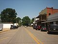
A view of downtown St. Joseph, part of its historic district.
-
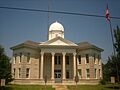
The Tensas Parish Courthouse, an important historic building.
-
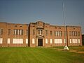
The old Waterproof High School building.
-
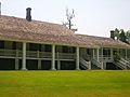
A view of Winter Quarters State Historic Site.


