
National Register of Historic Places listings in Twin Falls County, Idaho facts for kids

Have you ever wondered what makes a building or a place truly special? In the United States, there's a special list called the National Register of Historic Places. It's like a hall of fame for important historical sites! When a place is added to this list, it means it's recognized for its history, architecture, or what it teaches us about the past.
This article is about the amazing historic places found right here in Twin Falls County, Idaho. These places help us understand the unique story of our county and the people who lived here long ago. There are 42 special spots in Twin Falls County that are currently on this list. More might be added in the future, as new discoveries are made and old places are recognized!
What is the National Register of Historic Places?
The National Register of Historic Places is the official list of the nation's historic places worth saving. It's managed by the National Park Service. When a building, a site, a structure, an object, or even a whole historic district is listed, it gets special recognition. This helps protect it and makes people more aware of its importance.
Being on the Register doesn't stop people from changing or selling their property. But it does encourage them to preserve it. It can also help owners get grants or tax benefits to help with repairs. It's all about celebrating and keeping our history alive for future generations!
Historic Places in Twin Falls County
Twin Falls County is full of interesting history, from old schools and barns to important dams and downtown areas. Each place tells a part of the county's story. Let's explore some of these cool historic spots!
Historic Schools and Learning Places
Many old schools in Twin Falls County are on the National Register. These buildings remind us of how education has changed over the years.
- The Bickel School in Twin Falls, built in 1904, is a great example of early school architecture.
- Kimberly High School (built in 1912) and Lincoln School in Twin Falls (built in 1920) also show us what schools looked like a century ago.
- Other historic schools include Cedar Draw School (1917) near Buhl, Hollister School (1918), Pleasant Valley School (1916) near Kimberly, Pleasant View School (1917) near Twin Falls, and Union School (1918) near Filer. These old schoolhouses often have unique designs and stories.
Important Buildings and Downtown Areas
Many buildings in our towns are recognized for their history and design.
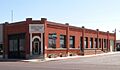
- The Buhl City Hall (built in 1919) and the Buhl IOOF Building (built in 1919) are important parts of Buhl's history. The IOOF building was home to a fraternal organization, a bit like a club, that helped people in the community.
- The Hotel Buhl (built in 1919) was once a fancy place for travelers and locals.
- The Ramona Theater (built in 1929) in Buhl is a beautiful old movie theater. Imagine watching a film there almost a hundred years ago!
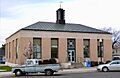
- The U.S. Post Office – Buhl Main (built in 1938) is another historic building that served the community for decades.
- In Twin Falls, the Twin Falls Bank and Trust Company Building (built in 1909) and the Twin Falls Canal Company Building (built in 1910) are important landmarks. The Canal Company building reminds us of how important irrigation was for farming in the area.
- The Twin Falls Milling and Elevator Company Warehouse (built in 1910) shows us how important agriculture was to the county's growth.
Historic Districts
Sometimes, not just one building, but a whole area is considered historic. These are called "historic districts."
- The Twin Falls City Park Historic District includes a beautiful park area.
- The Twin Falls Downtown Historic District covers a large part of the city center. It includes many old buildings that show how the town grew.
- The Twin Falls Original Townsite Residential Historic District and the Twin Falls Warehouse Historic District also preserve the look and feel of early Twin Falls.
Farms and Barns with History
Agriculture has always been a big part of Twin Falls County. Several old barns are on the National Register, showing us how farming was done in the past.
- The T. P. Bowlby Barn (built in 1912) and the Dau-Webbenhorst Barn (built in 1912) are examples of early 20th-century farm buildings.
- Other historic barns include the Rudolf Kunze Barn (built in 1912), the Art and Frieda Maxwell Barn (built in 1912), and the Henry Schick Barn (built in 1912). These barns are not just old; they represent the hard work and farming heritage of the region.
Water and Transportation Landmarks
Water has shaped Twin Falls County, especially with the Snake River and irrigation projects.
- Caldron Linn is a powerful waterfall on the Snake River. It was a significant landmark for early explorers.
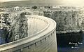
- The Milner Dam and the Twin Falls Main Canal (built in 1905) are incredibly important. This dam helped bring water to the dry lands of Twin Falls County, turning it into rich farmland.
- The Salmon Falls Dam (built in 1910) is another key part of the region's water history.
- The Toana Freight Wagon Road Historic District is an old road that was used to transport goods. It shows us how people traveled and traded long ago.
- The Stricker Store and Farm (built in 1865) was an important stop along an early travel route, providing supplies and a place to rest.
Historic Homes
Many old houses are also recognized for their unique architecture and the stories of the families who lived in them.
- The James Alvis House (built in 1909) in Twin Falls is a beautiful historic home.
- The Achille Duquesne House (built in 1912) in Filer and the Robert McCollum House (built in 1909) in Twin Falls are other examples.
- The Burton Morse House (built in 1910), D. H. Peck House (built in 1910), and Walter Priebe House (built in 1910) in Twin Falls also showcase the architectural styles of their time.
- The C. Harvey Smith House (built in 1909) is another notable historic residence.
Other Unique Sites
- The Idaho Power Substation (built in 1910) in Twin Falls shows the early development of electricity in the area.
- The Lincoln Street Electric Streetlights (installed in 1916) are a cool example of early city lighting.
Former Listings
Sometimes, a property might be removed from the National Register. This usually happens if the building is changed too much or is no longer standing. In Twin Falls County, two barns were once listed but have since been removed:
- The Alfred Carlson Barn (listed in 1983, delisted in 1989)
- The Gustave Kunze Barn (listed in 1983, delisted in 1994)
Even though they are no longer on the list, their history is still a part of Twin Falls County's story.
Images for kids
-
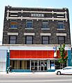
The historic Buhl IOOF Building.
-
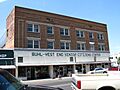
The Hotel Buhl, a grand hotel from 1922.
-

Milner Dam and the Twin Falls Main Canal, vital for irrigation.
-
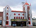
The Ramona Theater in Buhl, a classic movie house.
-
The Salmon Falls Dam, an important water project.
-
The Twin Falls Canal Company Building.
-
The U.S. Post Office in Buhl.


