
National Register of Historic Places listings in Vermillion County, Indiana facts for kids

This article is about some really cool and important places in Vermillion County, Indiana. These places are so special that they are listed on the National Register of Historic Places. Think of it like a national list of treasures that are important to history!
The National Register of Historic Places is an official list kept by the United States government. It helps protect buildings, sites, and objects that have a special meaning in American history, architecture, archaeology, engineering, or culture. When a place is on this list, it means it's recognized for its importance and efforts are made to preserve it for future generations.
In Vermillion County, Indiana, there are 9 properties and districts currently on this special list. One other place was once listed but has since been removed. This list will tell you a bit about each of these amazing historical spots!
Contents
What is the National Register of Historic Places?
The National Register of Historic Places is part of a bigger program to protect America's history. It's managed by the National Park Service. When a place is added to the Register, it gets special recognition. This can also help owners get grants or tax benefits to help take care of these historic spots.
These places can be anything from old houses and churches to bridges and even whole neighborhoods! They are chosen because they tell a story about our past. They might be where important events happened, or they might show us how people lived long ago.
Historic Places in Vermillion County
Let's explore some of the fascinating places in Vermillion County that are on the National Register of Historic Places. Each one has its own unique story!
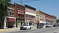
Clinton Downtown Historic District
The Clinton Downtown Historic District is a special area in the city of Clinton. It includes many buildings that show what the town looked like in the past. Walking through this district is like taking a step back in time! It was added to the Register on March 15, 2000.
Eugene Covered Bridge
The Eugene Covered Bridge is a beautiful old bridge located in Eugene Township. Covered bridges are very special because they are quite rare today. This bridge crosses the Big Vermillion River. It was added to the Register on June 10, 1994.

Hill Crest Community Center
The Hill Crest Community Center is a building in Clinton. Community centers are important places where people gather for events, meetings, and activities. This particular center has historical value, showing how communities came together in the past. It was listed on December 15, 1997.

Newport Covered Bridge
Another wonderful covered bridge in the county is the Newport Covered Bridge. You can find it northwest of Newport in Vermillion Township. It crosses the Little Vermillion River. Like the Eugene Covered Bridge, it was added to the Register on June 10, 1994.

Possum Bottom Covered Bridge
Vermillion County is lucky to have several covered bridges! The Possum Bottom Covered Bridge is another one. It's located southeast of Dana in Helt Township. This bridge was also added to the Register on June 10, 1994.

Salem Methodist Episcopal Church
The Salem Methodist Episcopal Church is a historic church building located north of Clinton in Helt Township. Churches often play a big role in a community's history, serving as places of worship and gathering. This church was listed on February 22, 1979.

Vermillion County Courthouse
The Vermillion County Courthouse is a very important building in Newport. Courthouses are usually grand buildings where local government business happens. This one is a symbol of the county's history and its legal system. It was added to the Register on December 19, 2007.

Vermillion County Jail and Sheriff's Residence
Also in Newport is the historic Vermillion County Jail and Sheriff's Residence. This building once served as both the county jail and the home for the local sheriff. It gives us a glimpse into how law enforcement worked in the past. It was listed on March 12, 1999.

A Former Listing
Sometimes, a place might be removed from the National Register of Historic Places. This can happen for different reasons, like if the building is moved or if it changes too much.
Brouilletts Creek Covered Bridge
The Brouilletts Creek Covered Bridge was once on the Register, listed on June 10, 1994. However, it was removed from the list on June 2, 1999. The bridge was taken apart in 1994 and is currently being stored. The hope is that it will be put back together in the future!
Images for kids
-
Main Street in downtown Clinton, part of the historic district.

