
National Register of Historic Places listings in Vernon Parish, Louisiana facts for kids

Have you ever wondered about old buildings or special places that tell a story about the past? In Vernon Parish, Louisiana, there are many such places! These important spots are listed on something called the National Register of Historic Places.
The National Register of Historic Places is like a special list kept by the United States government. It helps protect and celebrate buildings, sites, and objects that are important to American history, architecture, archaeology, engineering, or culture. When a place is on this list, it means it's recognized as a valuable part of our country's heritage.
In Vernon Parish, there are 16 different properties and areas that have made it onto this special list. These places include old homes, churches, bridges, and even parts of towns. They all have unique stories to tell about what life was like long ago in Louisiana.
What is the National Register of Historic Places?
The National Register of Historic Places (often called the NRHP) is the official list of places in the United States that are worth saving. It's managed by the National Park Service. Being on this list doesn't mean the government owns the property. It just means the place is recognized for its historical importance.
Why are places listed?
Places are listed on the NRHP for many reasons. Maybe a famous person lived there, or an important event happened there. Sometimes, a building is listed because it's a great example of a certain style of architecture. Listing a place helps people understand its history and encourages its preservation. It can also help property owners get special grants or tax benefits to help take care of these historic spots.
Historic Places in Vernon Parish
Vernon Parish is home to several fascinating historic sites. These places give us a peek into the past, showing us how people lived, worked, and built their communities.
Historic Homes
Many old houses in Vernon Parish are on the National Register. These homes often show us the building styles and daily lives of people from different time periods. For example, the Booker-Lewis House in Leesville is one such historic home. Another is the G.R. Ferguson, Sr. House, also in Leesville, which tells a story about the families who shaped the town. The Dr. William E. Reid House and the Edmond Ellison Smart House are more examples of important historic homes in Leesville. These houses help us imagine what life was like for families in the past.
Important Buildings and Structures
Beyond homes, other types of buildings and structures are also recognized. The First United Methodist Church in Leesville is listed, showing its importance to the community's spiritual and social history. The Kansas City Southern Depot in Leesville, an old train station, reminds us of how important railroads were for travel and trade.
The Vernon Parish Courthouse is another significant building. Courthouses are often central to a town's history, where important decisions were made and justice was served.
Unique Sites and Districts
Some listings aren't just single buildings. The Burr's Ferry Bridge is a historic bridge that connects Louisiana and Texas. Bridges like this are important for understanding how people traveled and moved goods between states. Near the bridge, the Burr's Ferry Earthworks are also listed. These are old military earthworks, which are like trenches or mounds built for defense, telling us about past conflicts.
The Downtown Leesville Historic District is an entire area, not just one building. This means a whole section of downtown Leesville has many historic buildings that together tell the story of the town's growth and development. Walking through a historic district is like stepping back in time!
Another unique site is the Fullerton Mill and Town. This refers to the remains of an old mill and the town that grew up around it, showing us how industries shaped communities in the past.
Grave Shelters
A very unique listing in Vernon Parish is the Talbert-Pierson Grave Shelters near Sugartown. These are special structures built over graves, which is a rare and interesting cultural practice. They show us different ways people honored their loved ones long ago.
Why These Places Matter
These historic places are more than just old buildings or sites. They are like open books that tell us about the history of Vernon Parish and Louisiana. They show us how people lived, worked, and built their communities over many years. By recognizing and protecting these places, we make sure that their stories can continue to be told for future generations. It helps us understand where we come from and how our towns and cities became what they are today.
Images for kids
-
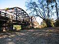
The historic Burr's Ferry Bridge.
-
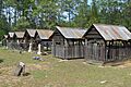
The unique Talbert-Pierson Grave Shelters.
-
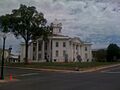
The Vernon Parish Courthouse in Leesville.


