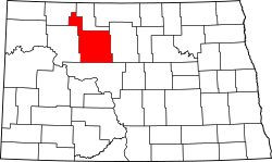
National Register of Historic Places listings in Ward County, North Dakota facts for kids
This is a list of the National Register of Historic Places listings in Ward County, North Dakota.
This is intended to be a complete list of the properties and districts on the National Register of Historic Places in Ward County, North Dakota, United States. The locations of National Register properties and districts for which the latitude and longitude coordinates are included below, may be seen in a map.
There are 15 properties and districts listed on the National Register in the county.
| Adams | Barnes | Benson | Billings | Bottineau | Bowman | Burke | Burleigh | Cass | Cavalier | Dickey | Divide | Dunn | Eddy | Emmons | Foster | Golden Valley | Grand Forks | Grant | Griggs | Hettinger | Kidder | La Moure | Logan | McHenry | McIntosh | McKenzie | McLean | Mercer | Morton | Mountrail | Nelson | Oliver | Pembina | Pierce | Ramsey | Ransom | Renville | Richland | Rolette | Sargent | Sheridan | Sioux | Slope | Stark | Steele | Stutsman | Towner | Traill | Walsh | Ward | Wells | Williams |
Current listings
| Name on the Register | Image | Date listed | Location | City or town | Description | |
|---|---|---|---|---|---|---|
| 1 | Andrew Carr, Sr. House |
(#84002771) |
510 4th Ave., NW. 48°14′25″N 101°18′06″W / 48.240278°N 101.301667°W |
Minot | ||
| 2 | Eastwood Park Bridge |
(#75001307) |
Central Ave. and 6th St., SE. 48°14′10″N 101°17′03″W / 48.236111°N 101.284167°W |
Minot | North Dakota's only false arch bridge | |
| 3 | Eastwood Park Historic District |
(#86002824) |
Bounded by Old Souris Oxbow 48°14′06″N 101°16′50″W / 48.235°N 101.280556°W |
Minot | ||
| 4 | Levi Glick Round Barn |
(#86002760) |
ND 38 48°13′29″N 101°10′20″W / 48.224722°N 101.172222°W |
Surrey | ||
| 5 | Minot Carnegie Library |
(#80002929) |
105 2nd Ave., SE. 48°14′05″N 101°17′27″W / 48.234722°N 101.290833°W |
Minot | ||
| 6 | Minot Commercial Historic District |
(#86002823) |
Roughly bounded by Soo Line railroad line, and Burdick Expressway, and Broadway 48°14′02″N 101°18′02″W / 48.233889°N 101.300556°W |
Minot | ||
| 7 | Minot Industrial Historic District |
(#86002818) |
Roughly bounded by the Souris River, 5th St., NE., 1st Ave., SE., 1st St., NE., Soo Line railroad line, and Broadway 48°14′19″N 101°17′17″W / 48.238611°N 101.288056°W |
Minot | ||
| 8 | Our Savior's Scandinavian Lutheran Church |
(#05000060) |
1 mile north of ND 50 and 0.25 miles west of Ward County Road 1 48°33′42″N 102°07′44″W / 48.561667°N 102.128889°W |
near Coulee | ||
| 9 | Soo Line Passenger Depot |
(#78001996) |
11 N. Main St. 48°14′13″N 101°17′34″W / 48.236944°N 101.292778°W |
Minot | ||
| 10 | South Prairie Community Hall |
(#06000474) |
177th Ave., SW. 48°03′17″N 101°17′57″W / 48.054722°N 101.299167°W |
Minot | ||
| 11 | Tufveson House |
(#84002773) |
426 4th Ave., NW. 48°14′26″N 101°18′05″W / 48.240556°N 101.301389°W |
Minot | ||
| 12 | U.S. Post Office-Minot |
(#80002930) |
100 1st St., SW. 48°14′04″N 101°17′36″W / 48.234444°N 101.293333°W |
Minot | ||
| 13 | Union National Bank and Annex |
(#83001941) |
2 N. Main and 7-11 E. Central Ave. 48°14′12″N 101°17′32″W / 48.236667°N 101.292222°W |
Minot | ||
| 14 | Ward County Courthouse |
(#85002997) |
315 3rd St., SE. 48°13′59″N 101°17′15″W / 48.233056°N 101.2875°W |
Minot | ||
| 15 | Westland Oil Filling Station |
(#86002816) |
510 E. Central Ave. 48°14′11″N 101°17′05″W / 48.236389°N 101.284722°W |
Minot |

All content from Kiddle encyclopedia articles (including the article images and facts) can be freely used under Attribution-ShareAlike license, unless stated otherwise. Cite this article:
National Register of Historic Places listings in Ward County, North Dakota Facts for Kids. Kiddle Encyclopedia.


