
National Register of Historic Places listings in Westerly, Rhode Island facts for kids
This is a list of Registered Historic Places in Westerly, Rhode Island.
Westerly, Rhode Island, is a town filled with amazing history! Many of its special buildings and areas are listed on the National Register of Historic Places. This is like a national list of important places that are worth protecting because of their history, architecture, or culture. When a place is on this list, it means it's recognized for its unique story and how it helps us understand the past. Let's explore some of these cool historic spots in Westerly!
Contents
- Exploring Westerly's Historic Treasures
- Babcock-Smith House
- Bradford Village Historic District
- Flying Horse Carousel
- Former Immaculate Conception Church
- Lewis-Card-Perry House
- Main Street Historic District
- North End Historic District
- US Post Office
- Watch Hill Historic District
- Weekapaug Inn
- Westerly Armory
- Westerly Downtown Historic District
- Wilcox Park Historic District
- Images for kids
Exploring Westerly's Historic Treasures
Babcock-Smith House
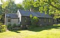
The Babcock-Smith House is a beautiful old home located at 124 Granite Street. It was added to the National Register of Historic Places on July 24, 1972. This house is a great example of the architecture from its time. It helps us imagine what life was like in Westerly many years ago.

Bradford Village Historic District
The Bradford Village Historic District is a special area that includes parts of both Hopkinton and Westerly. This district was recognized on May 30, 1996. It covers streets like Bowling Lane and Main Street, showing off a collection of historic buildings that tell the story of this village. It's like stepping back in time to see how the community grew.

Flying Horse Carousel
Get ready for some fun history! The Flying Horse Carousel, located on Bay Street, is one of the oldest carousels still working in the United States. It was built way back in 1876! What makes it super unique is that its horses hang from chains instead of being on poles. This gives them a "flying" motion as the carousel spins. It became a National Historic Landmark on January 11, 1980, meaning it's extra special!

Former Immaculate Conception Church
The building that used to be the Immaculate Conception Church is found at 119 High Street. It was added to the historic register on April 24, 1973. Even though it's no longer a church, this building still stands as an important part of Westerly's history and architectural heritage. It now serves as the George Kent Performance Hall, hosting events and performances.

Lewis-Card-Perry House
Another historic home in Westerly is the Lewis-Card-Perry House, located at 12 Margin Street. This house joined the National Register of Historic Places on October 4, 2005. It represents the style and history of homes from its era in the town.

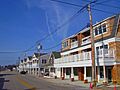
Main Street Historic District
The Main Street Historic District includes a section of Westerly's bustling Main Street, along with parts of School Street and Maple Street. This area was recognized as historic on January 9, 1978. It's a collection of buildings that show the development of Westerly's downtown over the years. Walking through it feels like a journey through time.

North End Historic District
The North End Historic District is a large area in Westerly that includes many streets like Canal, Dayton, and High Street. It was added to the National Register on April 20, 2006. This district showcases a variety of historic homes and buildings that tell the story of the community's growth in the northern part of town.
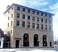
US Post Office
The United States Post Office building in Westerly, located at High and Broad Streets, is also a historic landmark. It was listed on August 12, 1971. This building is not just where you send mail; it's also a piece of architectural history, showing the style of government buildings from its time.

Watch Hill Historic District
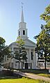
The Watch Hill Historic District is a famous seaside resort area in Westerly. It's roughly bordered by several roads, Block Island Sound, and Little Narragansett Bay. This district was added to the National Register on September 5, 1985. It's known for its well-preserved Victorian-era buildings, which are beautiful examples of architecture from the late 1800s. It's a popular spot with a lot of charm!

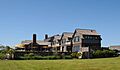
Weekapaug Inn
The Weekapaug Inn, located at 25 Spray Rock Road, is another significant historic place in Westerly. It was listed on January 25, 2007. This inn has been a popular destination for many years, offering a glimpse into the past of seaside hospitality and leisure.

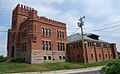
Westerly Armory
The Westerly Armory, found on Railroad Avenue west of downtown, is a historic military building. It was added to the National Register on November 7, 1996. Armories like this were important community centers and training grounds for local militias and National Guard units.

Westerly Downtown Historic District
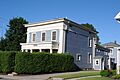
The Westerly Downtown Historic District covers a central part of the town, including Railroad Avenue, High, Canal, Broad, Union, and Main Streets. This district was recognized on July 19, 1984. It includes many of the commercial and civic buildings that have shaped Westerly's identity over the years. It's the heart of the town's history!

Wilcox Park Historic District
The Wilcox Park Historic District is centered around the beautiful Wilcox Park, bounded by Broad, Granite, High Streets, and Grove Avenue. It was listed on May 7, 1973. This district highlights not just buildings, but also the importance of public green spaces and how they contribute to a town's history and beauty.
_-_Westerly,_RI.JPG)
Images for kids
-
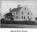
The historic Babcock-Smith House in Westerly.
-
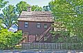
A view of the Bradford Village Historic District.
-
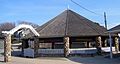
The historic Flying Horse Carousel, famous for its "flying" horses.
-
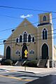
The former Immaculate Conception Church, now a performance hall.
-
The Lewis-Card-Perry House in Westerly.
-
Buildings within the Main Street Historic District.
-
A street view from the North End Historic District.
-
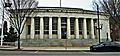
The historic U.S. Post Office in Westerly.
-
A scenic view of downtown Watch Hill, part of its historic district.
-
The historic Weekapaug Inn.
-
The Westerly Armory building.
-
A building in the Westerly Downtown Historic District.
-
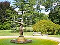
The fountain in Wilcox Park, part of its historic district.

