
National Register of Historic Places listings in Wrangell–St. Elias National Park and Preserve facts for kids
Wrangell-St. Elias National Park and Preserve in Alaska is a huge and amazing place. It's known for its tall mountains, big glaciers, and wild animals. But did you know it's also home to many important historic sites? These places tell stories about Alaska's past, especially about mining, transportation, and how people lived in this tough environment.
The National Register of Historic Places is like a special list of places in the United States that are important to history. When a place is on this list, it means it's worth protecting and learning about. Wrangell-St. Elias National Park and Preserve has nine of these special historic sites. One of them is even a National Historic Landmark, which means it's extra important to the whole country!
Let's explore some of these fascinating historic spots.
Contents
Exploring Historic Sites
Bremner Historic Mining District
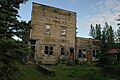
The Bremner Historic Mining District is found along Golconda Creek, about 47 miles (75 km) southeast of Chitina. This area was once a busy place where people searched for valuable minerals. It shows us what mining life was like in the early 1900s in remote Alaska. You can still see old buildings and equipment that tell the story of the miners who worked here.

Chisana Historic District
The Chisana Historic District is located near the Chisana Airstrip in Chisana. This district is important because it was the site of Alaska's last great gold rush in 1913. Many people rushed to Chisana hoping to strike it rich. The buildings and layout of the district still show how this boomtown grew and changed.

Chisana Historic Mining Landscape
Also in the Chisana area, the Chisana Historic Mining Landscape covers a wider area where mining activities took place. This landscape includes not just buildings, but also the land itself, showing how miners changed the environment to find gold. It helps us understand the challenges and methods of early mining in Alaska.

Kansky's
Kansky's is a historic site located at Mile 42 of the Nabesna Road, a few miles north of the Nabesna Mine. This spot likely served as a stop or a small settlement along the road, supporting the mining activities in the region. It represents the smaller, everyday places that were vital for people living and working in remote Alaska.
Kennecott Mines
The Kennecott Mines are perhaps the most famous historic site in the park. Located east of Kennicott Glacier, about 6.5 miles (10 km) north of McCarthy, this was once a huge copper mining operation. From 1911 to 1938, Kennecott produced over $200 million worth of copper, making it one of the richest copper mines in the world. Today, the large mill building and other structures are preserved, showing the scale of this industrial giant. It is a National Historic Landmark, recognized for its national importance.

McCarthy General Store
The McCarthy General Store is located at the corner of Kennicott Avenue and Skolai Street in McCarthy. McCarthy was the town that supported the Kennecott Mines. The general store was a central part of the community, where miners and residents could buy supplies, get their mail, and gather. It shows the daily life and commerce of a remote Alaskan mining town.

McCarthy Power Plant
Also in McCarthy, the McCarthy Power Plant is on the west side of Shushanna Avenue, along McCarthy Creek. This power plant was essential for providing electricity to the town and possibly to parts of the mining operations. It highlights the technology and infrastructure needed to support a community in such a remote area.
Nabesna Gold Mine Historic District
The Nabesna Gold Mine Historic District is found at the base of White Mountain, at the end of the Nabesna Road. This district represents another important gold mining area in the park. Like other mining sites, it tells the story of the challenges and rewards of searching for gold in Alaska's rugged landscape.
Valdez Trail-Copper Bluff Segment
The Valdez Trail-Copper Bluff Segment is a part of the historic Valdez Trail, located at Milepost 106.5 on the Richardson Highway near Copper City. The Valdez Trail was a crucial transportation route in early Alaska, used by miners, prospectors, and settlers to reach interior Alaska from the coast. This segment of the trail helps us understand how people traveled and moved goods across the vast Alaskan wilderness.
Images for kids
-
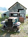
An old mechanic's shop at the Bremner Mining Camp.
-
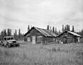
The historic post office in Chisana.
-
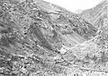
Mining operations along Bonanza Creek in the Chisana area.
-
The impressive mill building at Kennecott Mines.
-
The historic McCarthy General Store.
