Chitina, Alaska facts for kids
Quick facts for kids
Chitina
Tsedi Na'
|
|
|---|---|

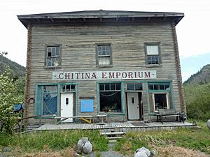
Chitina Emporium in 2011
|
|

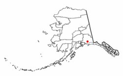
Location of Chitina, Alaska
|
|
| Country | United States |
| State | Alaska |
| Census Area | Copper River |
| Area | |
| • Total | 99.49 sq mi (257.67 km2) |
| • Land | 84.68 sq mi (219.31 km2) |
| • Water | 14.81 sq mi (38.35 km2) |
| Population
(2020)
|
|
| • Total | 101 |
| • Density | 1.19/sq mi (0.46/km2) |
| Time zone | UTC-9 (Alaska (AKST)) |
| • Summer (DST) | UTC-8 (AKDT) |
| ZIP code |
99566
|
| Area code(s) | 907 |
| FIPS code | 02-14110 |
Chitina is a small community in Alaska, United States. It is known as a "census-designated place" (CDP). This means it's an area identified by the government for gathering population data.
The name Chitina comes from the Ahtna language, which is spoken by some Native Alaskan people. In Ahtna, Tsedi Na means "copper river." This name makes sense because Chitina is located near the Copper River. In 2020, about 101 people lived in Chitina.
Contents
Where is Chitina Located?
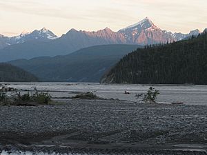
Chitina is found in the Copper River Census Area of Alaska. It sits on the west bank of the Copper River. The Chitina River also joins the Copper River here.
The community is along the Edgerton Highway. It's also where the McCarthy Road begins. Chitina is about 53 miles (85 km) southeast of Copper Center. It's also 66 miles (106 km) southeast of Glennallen. The area is just outside the western edge of the Wrangell - St Elias National Park and Preserve.
Roads and Travel in Chitina
In 1945, people started working to turn an old railroad line into a highway. This line went from Cordova to Kennicott. However, a big earthquake in 1964 stopped the work. This left a large gap in the road between Chitina and the Million Dollar Bridge near Cordova. Today, the old rail route from Chitina to Kennicott is now a roadway called the McCarthy Road.
The U.S. Census Bureau says that Chitina covers about 95.8 square miles (248 square kilometers). Most of this area, about 84.6 square miles (219 square kilometers), is land. The rest, about 11.1 square miles (29 square kilometers), is water.
What is Chitina's Climate Like?
Chitina has a type of weather called a continental subarctic climate. This means it has very cold, long winters and short, cool summers.
| Climate data for Chitina | |||||||||||||
|---|---|---|---|---|---|---|---|---|---|---|---|---|---|
| Month | Jan | Feb | Mar | Apr | May | Jun | Jul | Aug | Sep | Oct | Nov | Dec | Year |
| Record high °F (°C) | 52 (11) |
47 (8) |
49 (9) |
67 (19) |
85 (29) |
91 (33) |
88 (31) |
82 (28) |
69 (21) |
69 (21) |
46 (8) |
48 (9) |
91 (33) |
| Mean daily maximum °F (°C) | 0.4 (−17.6) |
17.2 (−8.2) |
31.9 (−0.1) |
44.7 (7.1) |
57.1 (13.9) |
64.9 (18.3) |
66.8 (19.3) |
63.7 (17.6) |
55.7 (13.2) |
38.5 (3.6) |
18.4 (−7.6) |
7.3 (−13.7) |
38.9 (3.8) |
| Mean daily minimum °F (°C) | −16.8 (−27.1) |
−4.6 (−20.3) |
4.9 (−15.1) |
23.6 (−4.7) |
34.3 (1.3) |
43.3 (6.3) |
46.9 (8.3) |
43.4 (6.3) |
34.9 (1.6) |
20.4 (−6.4) |
2.9 (−16.2) |
−9.9 (−23.3) |
18.6 (−7.4) |
| Record low °F (°C) | −55 (−48) |
−47 (−44) |
−41 (−41) |
−18 (−28) |
4 (−16) |
28 (−2) |
28 (−2) |
20 (−7) |
10 (−12) |
−20 (−29) |
−42 (−41) |
−56 (−49) |
−56 (−49) |
| Average precipitation inches (mm) | 0.56 (14) |
0.87 (22) |
0.31 (7.9) |
0.19 (4.8) |
0.34 (8.6) |
1.06 (27) |
1.32 (34) |
1.2 (30) |
1.19 (30) |
1.1 (28) |
1.24 (31) |
1.62 (41) |
10.99 (279) |
| Average snowfall inches (cm) | 3 (7.6) |
6.2 (16) |
2.1 (5.3) |
0.6 (1.5) |
0 (0) |
0 (0) |
0 (0) |
0 (0) |
0 (0) |
2.3 (5.8) |
7.4 (19) |
4.3 (11) |
26 (66) |
| Average precipitation days | 3 | 3 | 2 | 1 | 2 | 5 | 6 | 6 | 6 | 5 | 4 | 4 | 47 |
Who Lives in Chitina?
| Historical population | |||
|---|---|---|---|
| Census | Pop. | %± | |
| 1920 | 171 | — | |
| 1930 | 116 | −32.2% | |
| 1940 | 176 | 51.7% | |
| 1950 | 92 | −47.7% | |
| 1960 | 31 | −66.3% | |
| 1970 | 38 | 22.6% | |
| 1980 | 42 | 10.5% | |
| 1990 | 49 | 16.7% | |
| 2000 | 123 | 151.0% | |
| 2010 | 126 | 2.4% | |
| 2020 | 101 | −19.8% | |
| U.S. Decennial Census | |||
Chitina first appeared in the U.S. Census in 1920. Back then, it was just a small village. In 1980, it became a census-designated place (CDP).
In 2000, there were 123 people living in Chitina. About half of the people were White (51.22%). A good number were Alaskan Native (33.33%). The rest were from two or more different backgrounds.
The community had 52 households. About 23% of these households had children under 18 living there. The average household had about 2.37 people. The average age of people in Chitina was 39 years old.
Chitina's Past: A Look at its History

Native Athabascan people have lived in the Chitina area for hundreds of years. We know this from old archaeological sites found nearby. Before the 1900s, Chitina was a large village. However, its population slowly decreased as more people arrived, bringing new diseases and conflicts.
Around 1900, people found copper ore in the valley of the Chitina River. This discovery caused many prospectors and settlers to rush to the area. They hoped to find their fortune.
How Chitina Grew and Changed
In 1908, a man named Stephen Birch settled in the area. The Copper River and Northwestern Railway helped Chitina grow into a busy town by 1914. It had many businesses, including:
- A general store
- A clothing store
- A meat market
- Five hotels
- Restaurants and dance halls
- Even a movie theater!
From 1933 until 1938, a man named Otto Moses managed the general store. The copper mines in the area closed in 1938. After that, many of the businesses and people moved to the Glennallen area. Chitina almost became a ghost town.
Otto Adrian Nelson, an engineer, eventually bought many buildings in Chitina. He built a special system to provide electricity to his buildings. He also made sure many homes had hot and cold running water.
Chitina Today: Fishing and History
Today, a lot of activity in Chitina happens during the summer. This is when people come for "dipnet fishing" for salmon. Alaskans are allowed to catch a large number of salmon during their spawning runs. Chitina is a popular and easy-to-reach place for this type of fishing.
In the late 1970s, a jeweler named Art Koeninger bought the Chitina Tin Shop. He wanted to turn it into a home. In 1979, this historic building was added to the National Register of Historic Places. It has even received grants to help preserve it. Today, it is home to the Spirit Mountain Artworks.
See also
 In Spanish: Chitina (Alaska) para niños
 | DeHart Hubbard |
 | Wilma Rudolph |
 | Jesse Owens |
 | Jackie Joyner-Kersee |
 | Major Taylor |

