
Chitina River facts for kids
Quick facts for kids Chitina River |
|
|---|---|
.jpg)
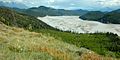
Chitina River below the confluences of the Nizina and Chakina Rivers
|
|

Location of the mouth of the Chitina River in Alaska
|
|
| Country | United States |
| State | Alaska |
| Census Area | Copper River |
| Physical characteristics | |
| Main source | Chitina Glacier Saint Elias Mountains, Wrangell–St. Elias National Park and Preserve 3,507 ft (1,069 m) 60°51′40″N 141°24′01″W / 60.86111°N 141.40028°W |
| River mouth | Copper River 1.2 miles (1.9 km) east of Chitina; 66 miles (106 km) northeast of Valdez, Chugach Mountains 466 ft (142 m) 61°29′50″N 144°25′10″W / 61.49722°N 144.41944°W |
| Length | 112 mi (180 km) |
| Basin features | |
| Tributaries |
|
The Chitina River is a 112-mile (180 km) long river in Alaska, USA. It is a major branch of the Copper River. The river's name comes from the Ahtna Athabascan words tsedi (meaning "copper") and na’ (meaning "river").
The Chitina River starts high up in the Saint Elias Mountains at the base of the Chitina Glacier. It flows mostly northwest through the huge Wrangell–St. Elias National Park and Preserve. Finally, it joins the Copper River near the town of Chitina. This area was once very important for mining copper.
Contents
Fun on the River: Rafting and Kayaking
The Chitina River is a great place for adventures like rafting, kayaking, and canoeing. But it's best for people who have good wilderness and whitewater skills. The river is rated as Class II (medium difficulty) on the International Scale of River Difficulty. This means it has some rapids but is generally manageable for experienced boaters.
You can start your trip near Hubert's Landing, which is a bit downstream from the Chitina Glacier. From there, the river stays Class II all the way to where it meets the Copper River. If you start at Hubert's Landing, you'll need to carry your boat for about 2.5 miles (4.0 km) to reach the main river. Another option is to start at Jake's Bar, which is about halfway between the glacier and the river's end. This shorter trip does not require carrying your boat.
Staying Safe on the Chitina River
When you're out on the Chitina River, it's important to be prepared. The water is very cold and silty, and the weather can change quickly. The river is also in a remote area, far from towns.
Grizzly bears are common in this region. They can be a danger to boaters, especially near smaller rivers that flow into the Chitina. Bears often gather in these spots because different types of salmon swim there. Salmon are a favorite food for bears.
Rivers that Join the Chitina
Many smaller rivers flow into the Chitina River. These are called tributaries.
Tributaries from the North
Most of the important tributaries from the north come from the southern slopes of the Wrangell Mountains. As you go downstream, these include:
- The Nizina River
- The Lakina River
- The Gilahina River
- The Kuskulana River
Tributaries from the South
From the south, the main rivers that join the Chitina come from the Chugach Mountains. These include:
- The Tana River
- The Chakina River
- The Tebay River
- The Kiagna River
The Tebay River and its connected lakes and streams are known for excellent wilderness fishing. You can catch fish like rainbow trout, lake trout, and Arctic grayling there.
Images for kids
-
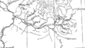
Map of the Chitina River
-
Chitina River from McCarthy Road, east of Chitina, Alaska, USA (28 June 2009)

.jpg)
