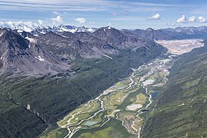
Tana River (Alaska) facts for kids
Quick facts for kids Tana River |
|
|---|---|

West Fork of the Tana River
|
|
|
Location of the mouth of the Tana River in Alaska
|
|
| Country | United States |
| State | Alaska |
| Census Area | Valdez–Cordova |
| Physical characteristics | |
| Main source | Bagley Icefield Tana Glacier, Wrangell–St. Elias National Park and Preserve 60°53′59″N 143°09′49″W / 60.89972°N 143.16361°W |
| River mouth | Chitina River Chugach Mountains 61°12′43″N 142°50′09″W / 61.21194°N 142.83583°W |
The Tana River is a river in south-central Alaska, United States. It flows into the Chitina River from the left side. The Tana River gets its water from the Tana Glacier. It starts by flowing along the eastern edge of the glacier. Then, it moves mostly north, following the glacier's end.
The Tana River valley creates a natural border. It separates the Saint Elias Mountains to the east from the Chugach Mountains to the west. After flowing for about 60 kilometers (37 miles), the Tana River joins the Chitina River.
Exploring the West Fork Tana River
The West Fork Tana River is another stream that flows into the Tana River. It gets its water from the Tana Glacier, specifically from the part that connects to the Bremner Glacier. This fork flows towards the east. After traveling about 24 kilometers (15 miles), the West Fork Tana River meets the main Tana River.
 | Chris Smalls |
 | Fred Hampton |
 | Ralph Abernathy |


