
Copper River (Alaska) facts for kids
Quick facts for kids Copper River |
|
|---|---|

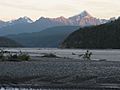
A fisherman (bottom center) dipnetting for salmon on the Copper River at Chitina in Southcentral Alaska
|
|
| Country | United States |
| State | Alaska |
| Physical characteristics | |
| Main source | Copper Glacier on Mount Wrangell 4,380 ft (1,340 m) 62°10′39″N 143°49′05″W / 62.17750°N 143.81806°W |
| River mouth | Copper Bay of Pacific Ocean 0 ft (0 m) 60°23′19″N 144°57′39″W / 60.38861°N 144.96083°W |
| Length | 290 mi (470 km) |
| Basin features | |
| Basin size | 24,000 sq mi (62,000 km2) |

The Copper River is a big river in south-central Alaska, in the United States. It's also known as the Ahtna River. In the Ahtna language, its name is ‘Atna’tuu, which means "river of the Ahtnas." The Tlingit people call it Eeḵhéeni, meaning "river of copper."
This river is about 290 miles (470 km) long. It flows from the Wrangell Mountains and Chugach Mountains all the way to the Gulf of Alaska. The Copper River is famous for its huge delta and its many wild salmon. These salmon are some of the most valuable in the world. The Copper River is the tenth largest river in the U.S. based on how much water flows out of its mouth.
Contents
What is the Copper River Like?
The Copper River starts at the Copper Glacier. This glacier is on the northeast side of Mount Wrangell, inside Wrangell–St. Elias National Park and Preserve. The river first flows north in a valley next to Mount Sanford. Then, it turns west, forming the edge of the Wrangell Mountains. It separates these mountains from the Mentasta Mountains.
.jpeg)
The river then turns southeast through a wide, marshy area. It reaches Chitina, where another river, the Chitina River, joins it. The Chitina River's name in Ahtna means "copper river."
The Copper River is about 290 miles (470 km) long. It drops about 12 feet for every mile it travels. The river drains a huge area of more than 24,000 square miles (62,000 km²). This area is about the size of West Virginia. The water in the river flows quite fast, averaging about 7 miles per hour.
After the Chitina River joins it, the Copper River flows southwest. It goes through a narrow, glacier-filled pass in the Chugach Mountains. This area is part of the Chugach National Forest. Near the river's mouth, there are tall sand dunes, some up to 250 feet (76 meters) high. Both Miles Glacier and Childs Glacier drop ice chunks directly into the river. This is called calving. The Copper River flows into the Gulf of Alaska near Cordova. Here, it forms a wide delta that is almost 50 miles (80 km) across.
Why is it Called the Copper River?
The river got its name because there were lots of copper deposits along its upper parts. Native Alaskans used this copper long ago. Later, settlers from the Russian Empire and the United States also used it. It was hard to get the copper out because the river's mouth was difficult to travel through.
From 1908 to 1911, a railway called the Copper River and Northwestern Railway was built. It went from Cordova through the river valley. This made it easier to get the copper, especially from the Kennecott Mine. This mine was found in 1898. The mine was closed in 1938. Today, it's a ghost town that tourists can visit. The National Park Service takes care of it as a historic site.
The Copper River Highway (Alaska Route 10) runs from Cordova along the lower Copper River. It follows the old railway path and ends at the Million Dollar Bridge across the river. Another road, the Tok Cut-Off (Alaska Route 1), follows the Copper River Valley on the north side of the Chugach Mountains.
Fishing for Salmon

The Copper River is famous for its salmon because over 2 million salmon use the river each year to lay their eggs. This creates many special kinds of salmon. They are known for having a lot of healthy fat.
The time for catching salmon for sale is very short. It starts in May for chinook salmon and sockeye salmon. This season only lasts for a few days or hours at a time. However, fishing for fun is open all year. The best time for sport fishing on the Copper River is from August to September. This is when the coho salmon come through.
The Alaska Department of Fish and Game (ADF&G) and the United States Department of the Interior work together to manage the fishing. They get information mainly from a sonar station at Miles Lake. They also get data from research stations at Baird Canyon and Canyon Creek.
Bird Watching at the Delta
The Copper River Delta is a huge area of wetlands. It covers about 700,000 acres (2,800 km²). This is the largest continuous wetland along the Pacific Coast of North America.
Every year, about 16 million shorebirds use this delta. This includes all the western sandpipers and dunlins in the world. The delta is also home to the largest group of nesting trumpeter swans. It is the only place known where the dusky Canada goose subspecies (Branta canadensis occidentalis) nests.
Images for kids
-
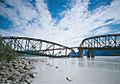
Miles Glacier Bridge, showing earthquake damage and temporary repair, 1984
-
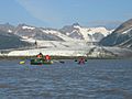
Rafters and Child's Glacier on the lower Copper River
-
Fishwheels on the Copper River
-
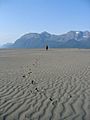
Sand dunes on the Copper River
-
Copper River near Chitina, looking south from the bridge
-
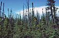
Black spruce taiga along the Copper River
-
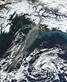
Wind picks up fine sediment from the riverbank and carries it over the ocean.


See also
 In Spanish: Río Copper para niños
