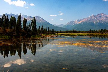
Mentasta Mountains facts for kids
Quick facts for kids Mentasta Mountains |
|
|---|---|

Mentasa Mts. as seen from the Tok Cut-Off (Glenn Hwy)
|
|
| Highest point | |
| Peak | Noyes Mountain (Alaska) |
| Elevation | 8,147 ft (2,483 m) |
| Dimensions | |
| Length | 40 mi (64 km) East-West |
| Width | 25 mi (40 km) North-South |
| Geography | |
| Country | United States |
| Range coordinates | 62°36′24″N 143°04′23″W / 62.60667°N 143.07306°W |
| Parent range | Alaska Range |
The Mentasta Mountains are a mountain range located in eastern Alaska, a state in the United States. These mountains mark the eastern end of the much larger Alaska Range.
They are surrounded by several important landmarks. To their south is the Alaska Highway, and to their east is the Glenn Highway. The Wrangell Mountains are to their north, and the Nabesna River flows to their west. The Mentasta Mountains also form the northern edge of the huge Wrangell–St. Elias National Park and Preserve.
The tallest peak in the Mentasta Mountains is Noyes Mountain. It stands tall at about 8,147 feet (2,483 m) (2,483 meters) above sea level.
Where are the Mentasta Mountains?
The Mentasta Mountains are found in a special part of Alaska. They are bordered by major roads and other mountain ranges. The Glenn Highway continues the Alaska Range on the other side. The Nutzotin Mountains are found across the Nabesna River.
This location makes the Mentasta Mountains an important natural boundary. They help define the northern border of Wrangell–St. Elias National Park and Preserve. This park is one of the largest protected areas in the United States.
 | Mary Eliza Mahoney |
 | Susie King Taylor |
 | Ida Gray |
 | Eliza Ann Grier |

