Nizina River facts for kids

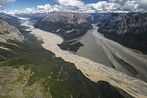
The Nizina River is a big river in Alaska, a U.S. state. It's the largest river that flows into the Chitina River. You can find the Nizina River inside the amazing Wrangell–St. Elias National Park and Preserve, which is a huge protected area.
Contents
Where the Nizina River Flows
The Nizina River starts at the Nizina Glacier. It flows south for about 16 miles (26 km). Then, it turns east and continues for another 16 miles (26 km) until it joins the Chitina River. This river drains a large area of about 1,240 square miles (3,211 sq km). It's almost as big as the Chitina River where they meet!
For the first 20 miles (32 km), the Nizina River flows over a wide, flat area made of gravel. This area can be from 0.5 to 2 miles (0.8 to 3.2 km) wide. Tall mountains, reaching 6,000 to 8,000 feet (1,829 to 2,438 meters) high, stand on either side.
When the water level is low, the river flows in one or a few paths that constantly change. As the water rises, more paths appear. During floods, the entire gravel area gets covered with fast-moving, muddy water. This water carries a lot of sand and gravel.
For the last 2 to 3 miles (3.2 to 4.8 km) of its journey, the river flows through a narrow space between solid rock walls. This forms what is called a "box canyon" for much of that distance. The river generally drops about 30 feet (9 meters) for every mile it travels.
Rivers That Join the Nizina
Many smaller rivers and creeks flow into the Nizina River. These are called its tributaries.
Chitistone River
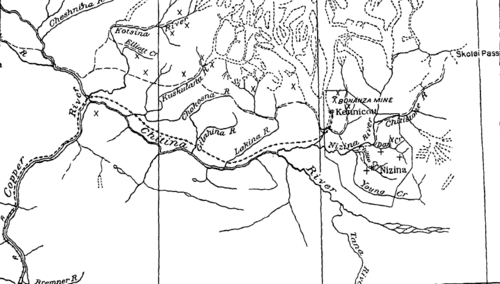
The Chitistone River begins at the Russell Glacier, near Skolai Pass. This is about 25 miles (40 km) northeast of where it meets the Nizina River. It flows through a narrow valley with very steep mountains on both sides, some reaching 8,000 to 9,000 feet (2,438 to 2,743 meters) high.
Dan and Chititu Creeks
Dan and Chititu creeks are smaller streams that join the Nizina River from the southeast. Dan Creek enters about 6 miles (9.7 km) below the Chitistone River, and Chititu Creek enters about 8 miles (12.9 km) below it. These creeks are important because gold was found in their areas. The area drained by Dan Creek is 42 square miles (109 sq km), and Chititu Creek drains 27 square miles (70 sq km).
Young Creek
Young Creek joins the Nizina about 1 mile (1.6 km) below Chititu Creek. It's about 30 miles (48 km) long and drains an area of 104 square miles (269 sq km). The lower part of Young Creek flows next to Chititu Creek, and its upper parts connect with Dan Creek. These creeks (Dan, Chititu, and Young) don't get much water from glaciers. They carry a lot of fine dirt (silt) from the rock formations they cut through, along with sand and gravel.
Kennicott River
The Kennicott River carries water from the Kennicott Glacier to the Nizina River, a distance of about 4 miles (6.4 km). This river can have very big floods, often one or more each year. These floods happen when ice and debris block the paths under the glacier. When enough water builds up, it creates pressure that forces the blockage out, causing a huge rush of water. These floods can sometimes last for several days.
McCarthy Creek
McCarthy Creek starts from small glaciers on the south side of the Wrangell Mountains. For about 13 miles (21 km), it flows south, running parallel to the Kennicott Glacier, which is 3 to 4 miles (4.8 to 6.4 km) to its west. The ridge separating them is a southern part of the Wrangell Mountains, ranging from 6,000 to 7,000 feet (1,829 to 2,134 meters) high.
McCarthy Creek then slowly turns west, and for its last 3 miles (4.8 km), it flows northwest. Its total length is about 20 miles (32 km), and it joins the Kennicott River near the town of McCarthy. The area it drains is 72 square miles (186 sq km). Its main smaller streams come from the east, including the East Fork and Nikolai Creek. These join about 10 miles (16 km) and 12 miles (19 km) respectively from the start of McCarthy Creek.
Below the East Fork, the stream flows between high gravel banks. It also cuts through rock formations, creating small canyons. About 3 miles (4.8 km) from where it meets the Kennicott, the flat area around the river widens to about 0.25 miles (0.4 km). McCarthy Creek generally drops about 100 feet (30 meters) for every mile it travels.
History of the Nizina River Area
Gold was first found in the Nizina River area in 1902. The "Nizina placer district" generally includes the areas drained by Dan, Chititu, and Young creeks. These creeks all flow into the Nizina River from the east and south. A "placer" is a deposit of valuable minerals, like gold, found in sand or gravel in a riverbed.
 | James Van Der Zee |
 | Alma Thomas |
 | Ellis Wilson |
 | Margaret Taylor-Burroughs |


