Chitistone Mountain facts for kids
Quick facts for kids Chitistone Mountain |
|
|---|---|

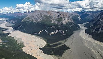
Chitistone Mountain, southwest aspect.
Nizina River (left) and Chitistone River (right). |
|
| Highest point | |
| Elevation | 6,844 ft (2,086 m) |
| Prominence | 994 ft (303 m) |
| Isolation | 3.07 mi (4.94 km) |
| Geography | |
| Location | Wrangell-St. Elias National Park Valdez-Cordova Borough Alaska, United States |
| Parent range | Wrangell Mountains |
| Topo map | USGS McCarthy B-4 |
Chitistone Mountain is a tall mountain in Alaska, USA. It stands about 6,844 feet (2,086 meters) high. You can find it at the edge of the Wrangell Mountains.
This mountain is inside the huge Wrangell–St. Elias National Park and Preserve. It's about 15 miles (24 km) from the town of McCarthy. The mountain sits right where the Nizina River and Chitistone River meet.
What's in a Name?
The mountain gets its name from the Chitistone River. This river's name comes from an old Native American word, chiti, which means copper. So, Chitistone basically means 'copper stone'!
The United States Geological Survey officially reported the mountain's name in 1959. The Chitistone River is part of the larger Copper River system.
Copper Mining History
The area west of Chitistone Mountain was once very busy with copper mining. From 1911 to 1938, the Kennecott Mines actively dug for copper here. This made the region an important place for getting valuable metals.
Mountain Weather
Chitistone Mountain is in a subarctic climate zone. This means it has very long, cold, and snowy winters. Summers are usually cool.
Weather systems from the Gulf of Alaska hit the Wrangell Mountains. The mountains force the air upwards, which causes a lot of rain and snow. This is called orographic lift.
Temperatures can drop below -20 °F (-29 °C). With the wind, it can feel even colder, sometimes below -30 °F (-34 °C). The best time to visit or climb the mountain is usually in May and June. The weather is often clearer and more pleasant then.
 | Leon Lynch |
 | Milton P. Webster |
 | Ferdinand Smith |


