Chisana, Alaska facts for kids
Quick facts for kids
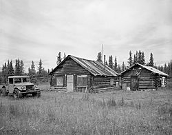
Chisana
Tsetsaan' Na'
|
|
|---|---|

Chisana's post office
|
|
| Country | United States |
| State | Alaska |
| Census Area | Copper River |
| Area | |
| • Total | 79.44 sq mi (205.74 km2) |
| • Land | 79.39 sq mi (205.61 km2) |
| • Water | 0.05 sq mi (0.13 km2) |
| Elevation | 3,369 ft (1,027 m) |
| Population
(2020)
|
|
| • Total | 0 |
| • Density | 0.00/sq mi (0.00/km2) |
| Time zone | UTC-9 (Alaska (AKST)) |
| • Summer (DST) | UTC-8 (AKDT) |
| Area code(s) | 907 |
| FIPS code | 02-13890 |
| GNIS feature ID | 1400321 |
|
Chisana Historic District
|
|
| Location | Extending west 0.25 miles (0.40 km) from the southern end of Chisana Airstrip |
|---|---|
| Nearest city | Northway |
| Area | 30 acres (12 ha) |
| Built | 1913 |
| NRHP reference No. | 85002999 |
| Significant dates | |
| Added to NRHP | November 29, 1985 |
|
Chisana Historic Mining Landscape
|
|
| Location | Address restricted |
|---|---|
| Nearest city | Northway |
| Area | 27,216 acres (11,014 ha) |
| Built | 1913 |
| NRHP reference No. | 98000436 |
| Added to NRHP | May 14, 1998 |
Chisana (also called Shushanna) is a special area in Alaska. It is known as a census-designated place (CDP). This means it is an area defined by the government for counting people, but it is not an official city or town.
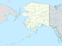
Chisana is located in the Copper River Census Area. The name Chisana comes from the Ahtna Athabascan people. In their language, it is called Tsetsaan' Na, which means 'copper river'. This is not the same as the larger Copper River in Alaska.
The Chisana River is a local waterway. It joins the Nabesna River to form the Tanana River. The Tanana River is a major branch of the Yukon River. Chisana also has a small airport. It has a runway made of turf and gravel. Most flights to Chisana come from Tok, Alaska.
In 1985, Chisana was recognized as a special historical site. It was listed as the Chisana Historic District on the National Register of Historic Places. This is a list of places in the United States that are important to history. Later, in 1998, an even larger area was added. This was the Chisana Historic Mining Landscape. It includes the community and a large area of about 27,000 acres.
Exploring Chisana's Location
Chisana is found in a vast area of Alaska. The United States Census Bureau says it covers about 86.7 square miles (224.5 square kilometers). Most of this area is land. Only a very small part, about 0.1 square miles (0.26 square kilometers), is water.
Chisana's Weather
Chisana has a subarctic climate. This means it has very long, cold winters and short, cool summers. The weather can be extreme. The hottest temperature ever recorded in Chisana was 90°F (32°C) in June 2004. The coldest temperature was a freezing -53°F (-47°C) in January 2013.
| Climate data for Chisana, Alaska, 2006–2020 normals, extremes 1992–present | |||||||||||||
|---|---|---|---|---|---|---|---|---|---|---|---|---|---|
| Month | Jan | Feb | Mar | Apr | May | Jun | Jul | Aug | Sep | Oct | Nov | Dec | Year |
| Record high °F (°C) | 53 (12) |
53 (12) |
63 (17) |
68 (20) |
79 (26) |
90 (32) |
87 (31) |
89 (32) |
75 (24) |
74 (23) |
45 (7) |
55 (13) |
90 (32) |
| Mean maximum °F (°C) | 33.9 (1.1) |
41.0 (5.0) |
47.3 (8.5) |
57.4 (14.1) |
70.8 (21.6) |
77.6 (25.3) |
80.1 (26.7) |
78.3 (25.7) |
67.8 (19.9) |
55.7 (13.2) |
31.9 (−0.1) |
31.5 (−0.3) |
81.8 (27.7) |
| Mean daily maximum °F (°C) | 2.2 (−16.6) |
17.7 (−7.9) |
28.1 (−2.2) |
44.4 (6.9) |
56.9 (13.8) |
64.8 (18.2) |
68.9 (20.5) |
64.5 (18.1) |
54.0 (12.2) |
35.8 (2.1) |
10.8 (−11.8) |
2.9 (−16.2) |
37.6 (3.1) |
| Daily mean °F (°C) | −8.1 (−22.3) |
1.3 (−17.1) |
8.3 (−13.2) |
27.1 (−2.7) |
41.7 (5.4) |
49.7 (9.8) |
53.4 (11.9) |
48.7 (9.3) |
39.3 (4.1) |
21.9 (−5.6) |
−0.2 (−17.9) |
−5.9 (−21.1) |
23.1 (−5.0) |
| Mean daily minimum °F (°C) | −18.2 (−27.9) |
−15.1 (−26.2) |
−11.5 (−24.2) |
9.8 (−12.3) |
26.4 (−3.1) |
34.5 (1.4) |
37.8 (3.2) |
32.9 (0.5) |
24.5 (−4.2) |
7.9 (−13.4) |
−11.2 (−24.0) |
−14.5 (−25.8) |
8.6 (−13.0) |
| Mean minimum °F (°C) | −40.4 (−40.2) |
−36.1 (−37.8) |
−32.6 (−35.9) |
−11.0 (−23.9) |
15.1 (−9.4) |
24.0 (−4.4) |
27.1 (−2.7) |
22.2 (−5.4) |
9.9 (−12.3) |
−15.3 (−26.3) |
−32.1 (−35.6) |
−33.7 (−36.5) |
−46.3 (−43.5) |
| Record low °F (°C) | −53 (−47) |
−52 (−47) |
−49 (−45) |
−39 (−39) |
2 (−17) |
19 (−7) |
24 (−4) |
16 (−9) |
−5 (−21) |
−31 (−35) |
−44 (−42) |
−49 (−45) |
−53 (−47) |
| Average precipitation inches (mm) | 0.53 (13) |
0.57 (14) |
0.37 (9.4) |
0.25 (6.4) |
1.02 (26) |
3.22 (82) |
2.55 (65) |
1.54 (39) |
1.10 (28) |
0.80 (20) |
0.70 (18) |
0.60 (15) |
13.25 (335.8) |
| Average extreme snow depth inches (cm) | 15.4 (39) |
18.3 (46) |
18.7 (47) |
17.7 (45) |
8.1 (21) |
0.0 (0.0) |
0.0 (0.0) |
0.0 (0.0) |
1.1 (2.8) |
4.9 (12) |
12.3 (31) |
15.4 (39) |
20.3 (52) |
| Average precipitation days (≥ 0.01 in) | 3.7 | 4.4 | 3.2 | 1.9 | 5.6 | 12.3 | 9.4 | 9.6 | 5.7 | 5.3 | 4.5 | 3.7 | 69.3 |
| Source 1: NOAA | |||||||||||||
| Source 2: National Weather Service | |||||||||||||
Who Lives in Chisana?
| Historical population | |||
|---|---|---|---|
| Census | Pop. | %± | |
| 1920 | 148 | — | |
| 1930 | 13 | −91.2% | |
| 1940 | 28 | 115.4% | |
| 2020 | 0 | — | |
| U.S. Decennial Census | |||
Chisana first appeared in the U.S. Census in 1920. At that time, 148 people lived there. It was counted again in 1930 and 1940. After that, it was not listed until 2000. In both the 2000 and 2010 counts, Chisana reported zero residents. This means no one was officially living there at the time of those censuses.
See also
 In Spanish: Chisana (Alaska) para niños
 | William L. Dawson |
 | W. E. B. Du Bois |
 | Harry Belafonte |


