
National Register of Historic Places listings in Yolo County, California facts for kids

This article is about the amazing historic places in Yolo County, California. These places are so special that they are on a list called the National Register of Historic Places. Think of it as a Hall of Fame for buildings, sites, and objects that tell important stories about our past.
Yolo County is in the central part of California. It's known for its rich farming areas and charming towns like Davis and Woodland. Many of the places on this list are found in these towns.
There are 26 historic places in Yolo County that are currently on the National Register. One place was on the list but has since been removed. Each spot on the list has a unique history. It helps us understand how people lived long ago.
Contents
What is the National Register of Historic Places?
The National Register of Historic Places is the official list of the nation's historic places. It is part of a program to help save and celebrate America's history. When a place is added to this list, it means it is important to local, state, or national history.
Being on the list can help protect these places. It also makes people more aware of their importance. These sites can be buildings, like old houses or schools. They can also be bridges, districts, or even archaeological sites. Each one has a story to tell.
Historic Places in Yolo County
Yolo County has many interesting places on the National Register. Let's explore a few of them. These sites show different parts of the county's history.
Historic Buildings in Woodland

Woodland is the county seat of Yolo County. It has many historic buildings.
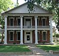
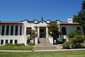
R. H. Beamer House
The R. H. Beamer House is a grand old home built in 1900. It is located at 19 3rd Street. This house shows the fancy architecture of its time. It reminds us of the wealthy families who lived in Woodland.
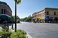
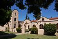
Downtown Woodland Historic District
The Downtown Woodland Historic District is not just one building. It is a whole area along Main Street. This district includes many buildings that show what downtown Woodland looked like in the past. Walking through it is like taking a step back in time. You can see different styles of buildings from the late 1800s and early 1900s.
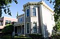
William B. Gibson House
The William B. Gibson House is another impressive home in Woodland. It is located at 512 Gibson Road. This house was built in 1891. It is a great example of Victorian architecture. It tells the story of early Woodland families.
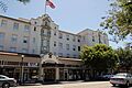
Hotel Woodland
The Hotel Woodland is a historic hotel at 426 Main Street. It was built in 1912. For many years, it was a central meeting place in Woodland. It hosted travelers and important events. It is still a beautiful landmark today.
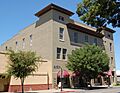
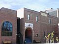
I.O.O.F. Building
The I.O.O.F. Building stands at 723 Main Street. I.O.O.F. stands for the Independent Order of Odd Fellows. This was a fraternal organization. Their building, constructed in 1905, was a place for meetings and community events. It shows the importance of community groups in the past.
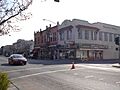
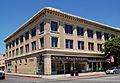
Porter Building
The Porter Building is located at 501-511 Main Street. It was built in 1913. This building is a good example of early 20th-century commercial architecture. It housed many businesses over the years. It played a big role in Woodland's business life.
Walnut Street School
The Walnut Street School at 175 Walnut Street was built in 1913. It served as a school for many generations of Woodland children. It is a reminder of the importance of education in the community's history.
Woodland Opera House
The Woodland Opera House at 320 2nd Street is a true gem. It was built in 1896. This beautiful theater hosted many plays, concerts, and events. It was a major entertainment spot for the region. It is still used for performances today.
Woodland Public Library
The Woodland Public Library at 250 1st Street was built in 1905. It was one of the many libraries funded by Andrew Carnegie. These libraries helped bring books and learning to communities across the country.
Yolo County Courthouse
The Yolo County Courthouse is at 725 Court Street. It was built in 1917. This grand building is where important legal decisions are made. It has been a symbol of justice in Yolo County for over a century.
Historic Places in Davis

Davis is another major city in Yolo County. It is home to the University of California, Davis.
Animal Science Building
The Animal Science Building is on the University of California, Davis campus. It was built in 1914. This building is important for its role in agricultural education and research. It helped shape farming practices in California.
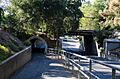
Davis Subway
The Davis Subway is a unique historic site. It is a tunnel under the railroad tracks on Richards Boulevard. Built in 1916, it helped people and cars get safely across town. It was a big step for transportation in Davis.
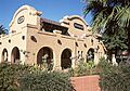
Dresbach-Hunt-Boyer House
The Dresbach-Hunt-Boyer House is at 604 2nd Street. This house was built in 1877. It is one of the oldest homes in Davis. It shows the early settlement and growth of the city.
Southern Pacific Railroad Station
The Southern Pacific Railroad Station is located at H and 2nd Streets. It was built in 1914. This train station was a vital link for Davis. It connected the town to the rest of California. It is still an active train station today.
Joshua B. Tufts House
The Joshua B. Tufts House is at 434 J Street. It was built in 1906. This house is a good example of early 20th-century homes in Davis. It reflects the growth of the town around the university.
Other Notable Historic Places

Yolo County has historic sites beyond its main cities.
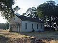
Canon School
The Canon School is located north of Brooks. It was built in 1868. This one-room schoolhouse is a rare survivor. It shows what rural education was like in the 1800s.
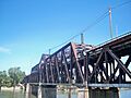
I Street Bridge
The I Street Bridge crosses the Sacramento River. It connects Sacramento and Yolo County. Built in 1911, this bridge is special because it can rotate. This allows boats to pass through. It was a major engineering feat for its time.
Main Street Historic District- Winters
The Main Street Historic District in Winters includes buildings from 1 to 48 Main Street. This district shows the historic downtown of Winters. It has many buildings from the late 1800s and early 1900s.
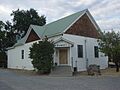
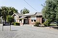
Rumsey Town Hall
The Rumsey Town Hall is in the small town of Rumsey. It is located on State Route 16. Built in 1914, this hall served as a community center. It was a place for meetings, events, and social gatherings in the rural area.
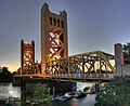
Tower Bridge
The Tower Bridge is another famous bridge crossing the Sacramento River. It connects Sacramento and West Sacramento (in Yolo County). Built in 1935, it is a vertical lift bridge. It is known for its distinctive gold color.
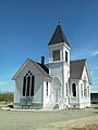
Union Church of Dunnigan
The Union Church of Dunnigan is at 3615 County Road 89A. It was built in 1906. This church served the small farming community of Dunnigan. It represents the importance of faith and community in rural life.
Yolo Branch Library
The Yolo Branch Library is at 200 Sacramento Street in the town of Yolo. Built in 1910, it is another Carnegie library. It brought books and learning to the people of Yolo.
Former Listing
One property was once on the National Register but has since been removed.
First Pacific Coast Salmon Cannery Site
The First Pacific Coast Salmon Cannery Site was located on the Sacramento River near Broderick. This site was important because it was where the first salmon cannery on the Pacific Coast was built. It played a big role in the fishing industry. However, it was removed from the list in 2004.
Images for kids
-

R. H. Beamer House
-
Canon School
-
Davis Subway
-
Downtown Woodland Historic District
-
Dresbach-Hunt-Boyer House
-
William B. Gibson House
-
Hotel Woodland
-
I Street Bridge
-
I.O.O.F. Building
-
Main Street Historic District- Winters
-
Porter Building
-
Rumsey Town Hall
-
Southern Pacific Railroad Station
-
Tower Bridge
-
Union Church of Dunnigan
-
Walnut Street School
-
Woodland Opera House
-
Woodland Public Library
-
Yolo Branch Library
-

Yolo County Courthouse


.jpg)


