National Weather Service Caribou, Maine facts for kids

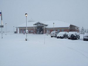
The office in winter 2011.
|
|
| Types | branch |
|---|---|
| Location | Caribou |
| Country | United States |
| Coordinates | 46°52′06″N 68°00′49″W / 46.8684089°N 68.0134779°W |
| Website | www |
The National Weather Service Caribou, Maine is a local office of the National Weather Service. This office watches weather conditions in northern Maine. It is located with a special facility that sends weather balloons high into the air. However, its main weather radar, called NEXRAD KCBW, is located further south near Houlton, Maine.
What the Caribou Weather Office Does
The National Weather Service in Caribou has an important job. It creates weather forecasts, which are predictions about future weather. It also issues hydrologic forecasts, which predict water levels in rivers and lakes. Climate forecasts, which look at long-term weather patterns, are also part of their work.
They also send out warnings for dangerous weather. All of this is done to keep people safe and to help the economy. They cover northeastern Maine and the nearby ocean areas.
NOAA Weather Radio Stations
The National Weather Service Caribou office also creates programs for eight NOAA Weather Radio stations in Maine. These radios broadcast important weather information 24 hours a day. They are especially helpful during emergencies.
Radio Station Details
Here is a list of the NOAA Weather Radio stations that the Caribou office helps to run:
| City of license | Call sign | Frequency (MHz) | Power |
|---|---|---|---|
| Ellsworth | KEC93 | 162.400 MHz | 1,000 watts |
| Milo | KHB54 | 162.550 MHz | 1,000 watts |
| Frenchville | KHB55 | 162.475 MHz | 300 watts |
| Meddybemps | KHC47 | 162.425 MHz | 300 watts |
| Greenville | WNG542 | 162.425 MHz | 300 watts |
| Jonesboro | WNG543 | 162.450 MHz | 1,000 watts |
| Caribou | WXM77 | 162.525 MHz | 200 watts |
| Springfield | WXN28 | 162.500 MHz | 1,000 watts |
 | Frances Mary Albrier |
 | Whitney Young |
 | Muhammad Ali |


