
Greenville, Maine facts for kids
Quick facts for kids
Greenville, Maine
|
|
|---|---|

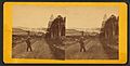
Town view in 1907
|
|

Location in Piscataquis County and the state of Maine.
|
|
| Country | United States |
| State | Maine |
| County | Piscataquis |
| Incorporated | 1836 |
| Area | |
| • Total | 46.13 sq mi (119.48 km2) |
| • Land | 42.33 sq mi (109.63 km2) |
| • Water | 3.80 sq mi (9.84 km2) |
| Elevation | 1,394 ft (425 m) |
| Population
(2020)
|
|
| • Total | 1,437 |
| • Density | 34/sq mi (13.1/km2) |
| Time zone | UTC-5 (Eastern (EST)) |
| • Summer (DST) | UTC-4 (EDT) |
| ZIP Codes |
04441 (Greenville)
04442 (Greenville Junction) |
| Area code(s) | 207 |
| FIPS code | 23-29535 |
| GNIS feature ID | 0582502 |
Greenville is a small town in Piscataquis County, Maine, United States. In 2020, about 1,437 people lived there. The town is located at the southern end of Moosehead Lake, which is the biggest freshwater lake in Maine.
Greenville is known as the main entry point to the northern parts of Maine. It's a popular spot for outdoor activities like hiking, fishing, and boating. Greenville High School was recognized as one of the top schools in Maine in 2010.
Contents
History of Greenville
Early Beginnings
The land where Greenville now stands was first called T9 R10 NWP. Around 1812, this land was given to Thornton Academy, a school in Saco. In 1824, a man named Nathaniel Haskell bought the land. He, along with Oliver Young and John Smith, started clearing trees to create farms near Wilson Pond. They chose this spot because Wilson Stream could power mills.
In 1827, Haskell finished building his house, and his family moved to join him. A sawmill was built on Wilson Stream in 1829. A year later, a gristmill (for grinding grain) was added.
Growing into a Town
In 1835, Henry Gower began clearing land right next to Moosehead Lake. This area would later become the main village of Greenville. He built the first hotel, called The Seboomook House, and the first store there.
On February 6, 1836, Greenville officially became a town. It was named "Greenville" because of its many green forests. By 1846, the village had grown to include two houses, two blacksmith shops, and a schoolhouse.
Travel and Tourism
In 1836, a small steamboat was launched on Moosehead Lake to help move logs. By 1838, a larger lake steamer began operating. Over the years, several steamers named Katahdin sailed the lake. The current S/S Katahdin was built in 1914 and is still around today.
In July 1884, the Bangor and Piscataquis Railroad (later the Bangor and Aroostook Railroad) reached Greenville. The Canadian Pacific Railway also built a line through the village in 1888. These railroads made it easier for people to visit.
Tourists were drawn to the area's beautiful scenery, great hunting, and fishing. Because of this, many inns and hotels were built, like the Piscataquis Exchange Hotel and the Moosehead Inn. Steamboats could take visitors across Moosehead Lake to the grand Mount Kineo House. Today, Greenville is still a very popular place for vacations and outdoor adventures.
A Special Event: The 2024 Eclipse
Greenville was in the perfect spot to see the total solar eclipse on April 8, 2024. During a total eclipse, the moon completely blocks the sun, making the sky dark in the middle of the day.
Geography and Climate
Greenville's Location
Greenville covers about 46.13 square miles (119.48 square kilometers). Most of this area is land, but about 3.80 square miles (9.84 square kilometers) is water, mainly from Moosehead Lake. Wilson Stream also flows through the town.
Greenville is located north of the 45th parallel. This means it's on a similar line of latitude as Montreal. Because of its northern location, Greenville's weather and plants are more like those found in northern parts of the United States and southern Canada than in southern Maine.
Greenville's Weather
Greenville has a humid continental climate. This means it has big differences in temperature throughout the year. Summers are warm to hot, and often humid. Winters are cold, and sometimes very cold.
| Climate data for Greenville Municipal Airport, Maine, 1991–2020 normals, extremes 1920–present | |||||||||||||
|---|---|---|---|---|---|---|---|---|---|---|---|---|---|
| Month | Jan | Feb | Mar | Apr | May | Jun | Jul | Aug | Sep | Oct | Nov | Dec | Year |
| Record high °F (°C) | 58 (14) |
55 (13) |
76 (24) |
85 (29) |
90 (32) |
95 (35) |
95 (35) |
96 (36) |
92 (33) |
84 (29) |
74 (23) |
59 (15) |
96 (36) |
| Mean maximum °F (°C) | 43.7 (6.5) |
43.5 (6.4) |
53.0 (11.7) |
69.9 (21.1) |
81.8 (27.7) |
85.5 (29.7) |
86.6 (30.3) |
85.6 (29.8) |
81.7 (27.6) |
71.7 (22.1) |
59.7 (15.4) |
48.0 (8.9) |
88.9 (31.6) |
| Mean daily maximum °F (°C) | 22.9 (−5.1) |
25.3 (−3.7) |
34.4 (1.3) |
46.4 (8.0) |
61.5 (16.4) |
70.2 (21.2) |
75.4 (24.1) |
74.1 (23.4) |
66.1 (18.9) |
52.5 (11.4) |
39.3 (4.1) |
28.3 (−2.1) |
49.7 (9.8) |
| Daily mean °F (°C) | 14.2 (−9.9) |
16.3 (−8.7) |
25.6 (−3.6) |
38.0 (3.3) |
51.4 (10.8) |
60.7 (15.9) |
66.3 (19.1) |
64.8 (18.2) |
57.2 (14.0) |
44.9 (7.2) |
32.9 (0.5) |
21.5 (−5.8) |
41.2 (5.1) |
| Mean daily minimum °F (°C) | 5.4 (−14.8) |
7.3 (−13.7) |
16.8 (−8.4) |
29.5 (−1.4) |
41.3 (5.2) |
51.2 (10.7) |
57.2 (14.0) |
55.5 (13.1) |
48.3 (9.1) |
37.3 (2.9) |
26.5 (−3.1) |
14.6 (−9.7) |
32.6 (0.3) |
| Mean minimum °F (°C) | −13.4 (−25.2) |
−10.5 (−23.6) |
−4.5 (−20.3) |
17.6 (−8.0) |
30.3 (−0.9) |
40.2 (4.6) |
48.3 (9.1) |
45.7 (7.6) |
35.2 (1.8) |
25.5 (−3.6) |
11.5 (−11.4) |
−4.1 (−20.1) |
−16.5 (−26.9) |
| Record low °F (°C) | −36 (−38) |
−42 (−41) |
−27 (−33) |
−8 (−22) |
18 (−8) |
24 (−4) |
27 (−3) |
30 (−1) |
20 (−7) |
10 (−12) |
−6 (−21) |
−32 (−36) |
−42 (−41) |
| Average precipitation inches (mm) | 2.98 (76) |
2.41 (61) |
3.19 (81) |
3.59 (91) |
3.59 (91) |
4.04 (103) |
4.01 (102) |
3.96 (101) |
3.44 (87) |
5.00 (127) |
3.96 (101) |
4.33 (110) |
44.50 (1,130) |
| Average precipitation days (≥ 0.01 in) | 13.0 | 11.8 | 12.8 | 13.4 | 13.5 | 14.1 | 14.2 | 13.1 | 10.6 | 13.7 | 13.7 | 15.8 | 159.7 |
| Source 1: NOAA | |||||||||||||
| Source 2: National Weather Service | |||||||||||||
Population of Greenville
| Historical population | |||
|---|---|---|---|
| Census | Pop. | %± | |
| 1840 | 128 | — | |
| 1850 | 326 | 154.7% | |
| 1860 | 310 | −4.9% | |
| 1870 | 369 | 19.0% | |
| 1880 | 586 | 58.8% | |
| 1890 | 781 | 33.3% | |
| 1900 | 1,117 | 43.0% | |
| 1910 | 1,474 | 32.0% | |
| 1920 | 1,550 | 5.2% | |
| 1930 | 1,615 | 4.2% | |
| 1940 | 1,955 | 21.1% | |
| 1950 | 1,889 | −3.4% | |
| 1960 | 2,025 | 7.2% | |
| 1970 | 1,894 | −6.5% | |
| 1980 | 1,839 | −2.9% | |
| 1990 | 1,884 | 2.4% | |
| 2000 | 1,623 | −13.9% | |
| 2010 | 1,646 | 1.4% | |
| 2020 | 1,437 | −12.7% | |
| U.S. Decennial Census | |||
Population in 2010
According to the census in 2010, Greenville had 1,646 people living in 820 households. About 19.4% of these households had children under 18. The average household had about 2 people.
The average age of people in Greenville was 52.3 years. About 15.9% of residents were under 18, and 24.2% were 65 or older. The population was almost evenly split between males (48.3%) and females (51.7%).
Population in 2000
In the year 2000 census, there were 1,623 people in Greenville. The average age was 43 years old. About 24% of the population was under 18, and 20.1% was 65 or older.
Images for kids
-
Moosehead Lake from Indian Hill c. 1875
-
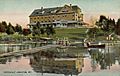
Moosehead Inn in 1908
-
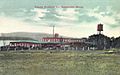
Veneer Products Co. in 1914


See also
 In Spanish: Greenville (Maine) para niños
