Neighborhoods in Lincoln, Nebraska facts for kids
Welcome to Lincoln, Nebraska! This city is made up of many different areas called neighborhoods. Each neighborhood has its own unique feel and history. The City of Lincoln officially recognizes 45 neighborhoods within its limits. Let's explore some of them!
Contents
Exploring Lincoln's Neighborhoods
Lincoln's neighborhoods offer a mix of homes, parks, schools, and businesses. Some are historic, while others are still growing and developing.
Central and South Lincoln Areas
- 40th & A: This area is located between Randolph and South Streets/Normal Boulevard, and from S. 33rd to S. 48th Streets.
- Antelope Park: You'll find this neighborhood between A and South Streets, generally west of Antelope Park itself, and east of S. 27th Street.
- Colonial Hills: This neighborhood stretches from Pioneers Boulevard to Old Cheney Road/Nebraska Highway, and from S. 56th to S. 70th Streets. It also includes an area near the College View Cemetery.
- Country Club: Located from South Street to Nebraska Highway, this area is generally east of S. 20th/S. 22nd Streets and west of the Rock Island Bicycle Trail. It includes Sheridan Boulevard, which was one of the first areas in Lincoln to have winding streets instead of a straight grid pattern. This historic area is known as the "Boulevards" district.
- Everett: This neighborhood is bordered by H Street to the north, South Street to the south, 9th Street to the west, and 13th Street to the east.
- Far South: This area is bordered by the Rock Island Bicycle Trail to the north, Mocking Bird Lane N. to the south, and extends from Densmore Park east to S. 27th Street.
- Greater South: This neighborhood is located from South Street to Highway 2, and from 33rd to 40th Streets.
- Indian Village: The Indian Village neighborhood is found from Van Dorn Street to Highway 2, and from 9th Street to 20th Street.
- Irvingdale: This neighborhood is located from South Street to Van Dorn Street, and from 9th Street to 22nd Street. It has a mix of older homes from the early 1900s and newer ones from the 1950s. Irving Middle School and the Stransky Park concert series are here.
- Near South: This area is home to many of Lincoln's grand historic homes. It's located from G Street to South Street, and from 13th Street to 27th Street. Many old homes that were once divided into apartments are now being turned back into single-family homes.
- Pester Ridge: This small area is located near South 33rd and West Denton Road.
- Piedmont: This neighborhood is west of Eastridge, bordered by S 48th to the west, S 56th to the east, A Street to the south, and Randolph Street to the north. It has a shopping center, a middle school, a church, a park, and homes.
- Porter Ridge: This area is bordered by Pine Lake Road to the north, and extends from S. 27th to S. 32nd Streets.
- South 48th: This is a narrow strip from O Street to Highway 2, roughly between 46th and 50th Streets.
- South Salt Creek: This neighborhood is located from O Street to Van Dorn Street, and from Salt Creek to 9th Street.
- Southern Hills: This area is just north of South Pointe Mall.
- Taylor Park: This neighborhood is generally located around Taylor Park in east-central Lincoln. It's bordered by O Street to the north, A Street to the south, 48th Street to the west, and 70th Street to the east.
- Witherbee: This area is located from O Street to Randolph Street, and from S. 33rd to S. 56th Streets.
- Woods Park (Historic Bungalow District): This neighborhood is known for its bungalow-style homes built in the 1910s and 1920s. It's bordered by O Street to the north, S. 33rd Street to the east, and is generally north and east of Antelope Creek. The Lincoln Children's Zoo is located nearby.
- Yankee Hill: Located south of Wilderness Ridge, this neighborhood's borders are West Van Dorn to the north, West Old Cheney to the south, Coddington to the west, and South 1st to the east.
East Lincoln Areas
- Bethany: This neighborhood is located along Cotner Boulevard and Holdrege Street. Bethany started as a separate village founded by the Disciples of Christ church. It became its own town in 1890 and joined Lincoln in 1922.
- College View: College View is located along 48th Street and near Calvert Street, surrounding the Union College campus. A small village grew around Union College when it was founded in 1891. College View became its own town in 1892 and joined Lincoln in 1929. It still has a small-town feel with local businesses that serve the college and the neighborhood.
- East Campus: Located just south of the University of Nebraska's East Campus, this neighborhood is from Holdrege to Vine and from 33rd to 48th Street. It includes a historic area called "Professors Row" and McAdams Park, which is next to the Mo-Pac Bicycle Trail.
- Eastridge: This neighborhood grew as Lincoln expanded eastward and the Gateway Mall became a major shopping area. It mostly has single-level, ranch-style homes built in the 1950s and 1960s. Eastridge Elementary School is also nearby.
- Family Acres: This large area is located from 56th to 84th Streets and from Yankee Hill to Old Cheney Road. It also includes parts of Old Cheney to Pioneers from 70th to 84th.
- Far Southeast: This is one of Lincoln's newest and fastest-growing neighborhoods. It developed quickly in the late 2000s and early 2010s, extending from 84th Street to 98th Street, and from Pioneers Boulevard to Pine Lake Road.
- Fox Hollow: Located in southeast Lincoln, this planned neighborhood was built from the 1970s onwards. It's found from 70th to 84th Streets between Van Dorn Street and Pioneers Boulevard.
- Meadowlane: This neighborhood is located from 66th to 84th Streets and from O Street to Vine Street, and from 70th to 84th Streets and from Vine Street to Holdrege Street.
- Riley: This area is located from Holdrege to O Streets, and from N. 48th to N. 66th Streets.
- University Place: University Place is located along 48th Street between Leighton Avenue and Adams Street, near Nebraska Wesleyan University and UNL's East Campus. It was its own community before joining Lincoln in 1926. It has its own historic shopping area and homes with wrap-around porches near the university.
North and Northwest Lincoln Areas
- Arnold Heights (Air Park): Located in far northwest Lincoln, this neighborhood is often called Air Park. It started as housing for the Lincoln Air Force Base during the Cold War. About 1,000 homes were built here. After the base closed, Lincoln added the area to the city in 1966. Many of the homes have since been sold to private owners. The area continues to grow with new homes, duplexes, a grocery store, and a shopping center.
- Autumn Wood: This neighborhood is located from Folkways to Fletcher, west of 27th Street.
- Belmont: The Belmont neighborhood is just north of Cornhusker Highway and south of Superior Street, between Interstate 180 and 14th Street.
- Clinton: This north-central neighborhood is centered around 27th and Holdrege streets. It's a diverse area with single-family homes, duplexes, and small apartment buildings. It's convenient for people who work downtown or are students at the University of Nebraska-Lincoln (UNL) because of its bike trails and bus lines. North 27th Street has many different ethnic restaurants and markets. The Clinton Neighborhood Organization started in 1968 and is the oldest neighborhood group in the city.
- Havelock: Havelock is located along Havelock Avenue, east of 56th Street in northeast Lincoln. It was founded in 1890 because of the Burlington & Missouri River Railroad. Havelock became a town in 1893. Its residents didn't want to join Lincoln at first, but after a long strike at the local Burlington Shops, which were very important to Havelock's economy, they voted to join Lincoln in 1930. Havelock still has a strong community feel with many shops, restaurants, and its own farmers market. It was named after Sir Henry Havelock, an English general.
- Highlands: The Highlands is a newer residential neighborhood in northwest Lincoln, located north of I-80 and near Lincoln Airport.
- Landon's: This neighborhood is located from Fairfield north to Superior, and from 27th Street west to between 21st and 20th Streets.
- Malone: This area is bordered by the old Missouri Pacific Railroad line to the north, O Street to the south, and from N. 19th to N. 27th Streets.
- Salt Valley View: This area is located from just north of Starview Lane to Old Cheney Road, and from the BNSF Railway to N. 14th Street/Warlick Boulevard.
- Sunset Acres: This neighborhood is located from 27th Street to 48th Street, and from Superior Street to Highway 6.
- West Lincoln: Located along W Cornhusker Highway, this area was founded in 1887 and was its own community before joining Lincoln in 1966.
Downtown and Historic Areas

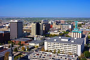
View of Downtown Lincoln from the top of the Nebraska State Capitol Building
- Capitol Beach: This area is north of West O Street, just west of Downtown, and north of BNSF Railway's Hobson Yard. It's home to Capitol Beach Lake and Lakeview Elementary School.
- Capitol View: This neighborhood is located from L Street to G Street, and from 13th Street to Capitol Parkway.
- Downtown: This is Lincoln's main business area, with a mix of offices, restaurants, and shops.
- Hawley: Located directly east of UNL's downtown campus, the Hawley Historic District was mostly built in the early 1900s.
- Haymarket: One of Lincoln's oldest neighborhoods, the Haymarket was once a historic area with warehouses and factories. In recent years, it has become a popular place for dining, unique shopping, and city living.
- Huskerville: This neighborhood no longer exists. It was built north of Arnold Heights during World War II as a hospital area for the Lincoln Army Air Field. After the war, it became housing for college students. It was removed or torn down in the late 1960s. Only the chapel, which is a historic landmark, remains.
- Russian Bottoms / [The] Bottoms: This area includes both the North Bottoms and South Bottoms. It was originally settled by people called Volga-German immigrants from Russia.
- North Bottoms: This area is directly north of UNL's downtown campus. It's in the floodplain of Salt Creek and has many smaller houses, often rented by UNL students. It's the northern part of the area where thousands of Volga-German immigrants from Russia first settled.
- South Bottoms: This area is south of the Haymarket, stretching to about A Street. It's the southern part of the area where thousands of Volga-German immigrants from Russia first settled.
Developing and West Lincoln Areas
- Fallbrook: This is a newer, still-developing community located east of the airport and north of I-80. It includes office parks, housing, a gym, a middle school, a supermarket, and a town center. Fallbrook also hosts farmers' markets during certain times of the year.
- High Ridge/Cushman: This area is located south and west of West O Street and SW 40th Street.
- Hitching Post Hills: This neighborhood is located in West Lincoln.
- West "A": The West "A" neighborhood is located from West "O" to W. Van Dorn Streets, and from Salt Creek to SW 27th Street. It also includes the area from W. "A" to W. South Streets, and from SW 40th to SW 27th Streets.
Black History Month on Kiddle
African-American female entrepreneurs
 | Madam C. J. Walker |
 | Janet Emerson Bashen |
 | Annie Turnbo Malone |
 | Maggie L. Walker |

All content from Kiddle encyclopedia articles (including the article images and facts) can be freely used under Attribution-ShareAlike license, unless stated otherwise. Cite this article:
Neighborhoods in Lincoln, Nebraska Facts for Kids. Kiddle Encyclopedia.

