Nekoma, Illinois facts for kids
Quick facts for kids
Nekoma, Illinois
|
|
|---|---|
| Country | |
| State | |
| County | Henry County |
| Township | Weller Township |
| Area | |
| • Total | 0.13 sq mi (0.34 km2) |
| • Land | 0.13 sq mi (0.34 km2) |
| • Water | 0.00 sq mi (0.00 km2) |
| Elevation | 810 ft (247 m) |
| Population
(2020)
|
|
| • Total | 23 |
| • Density | 175.57/sq mi (68.03/km2) |
| ZIP code |
61490
|
| GNIS feature ID | 0414345 |
Nekoma is a small place in Illinois, United States. It's called an unincorporated community. This means it's a group of homes and buildings that don't have their own local government, like a city or town does. Instead, it's part of a larger area called Weller Township in Henry County.
A Look Back in Time
The community of Nekoma was first planned out in July 1869. This is when people decided where the streets and buildings would go to start a new community.
Where is Nekoma?
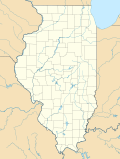
Nekoma is located in the southern part of Henry County, Illinois. You can find it where two important roads meet: Illinois Route 17 and Illinois Route 82.
Who Lives in Nekoma?
This section tells us about the people living in Nekoma. It's called demographics.
| Historical population | |||
|---|---|---|---|
| Census | Pop. | %± | |
| 2020 | 23 | — | |
| U.S. Decennial Census | |||
According to the 2020 United States Census, 23 people lived in Nekoma.
Black History Month on Kiddle
Famous African-American Pilots:
 | Bessie Coleman |
 | Spann Watson |
 | Jill E. Brown |
 | Sherman W. White |

All content from Kiddle encyclopedia articles (including the article images and facts) can be freely used under Attribution-ShareAlike license, unless stated otherwise. Cite this article:
Nekoma, Illinois Facts for Kids. Kiddle Encyclopedia.


