Nibley Knoll facts for kids
| Site of Special Scientific Interest | |

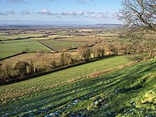
Long distance view to Nibley Knoll and Wotton Hill
|
|
| Area of Search | Gloucestershire |
|---|---|
| Coordinates | 51°39′33″N 2°22′15″W / 51.659048°N 2.370763°W |
| Interest | Geological |
| Area | 3.2 hectare |
| Notification | 1974 |
Nibley Knoll is a special place in Gloucestershire, England. It's officially recognized as a Site of Special Scientific Interest (SSSI) because of its amazing geology. This means it's a protected area where scientists can study important rocks and landforms.
The site is about 3.2 hectares big. It was first protected in 1974. Nibley Knoll is also known as a Regionally Important Geological Site (RIGS). This means it's a key spot for understanding the geology of the local area.
Contents
What Makes Nibley Knoll Special?
Nibley Knoll is located in the Cotswolds, a beautiful area known for its rolling hills. This area is also an Area of Outstanding Natural Beauty. The site is very important for geology because it shows a thick stack of rocks from the Lower and Middle Jurassic period.
Jurassic Rocks and Time
The Jurassic period was a long time ago, when dinosaurs roamed the Earth! The rocks at Nibley Knoll help us understand this ancient time. They show a clear change between two parts of the Jurassic period: the Aalenian and Bajocian Stages. These are like chapters in Earth's history book.
The oldest rocks you can see here are part of the Cotswold Sand Formation. These sandy layers are from the Upper Lias, an even older rock layer. You can spot these rocks in the cuts along the sunken lanes, which are old roads that have worn down into the ground.
Fossils and Ancient Seas
Above the sandy layers, there's a special rock layer called the Cephalopod bed. This layer is full of fossils from ancient sea creatures called cephalopods. These creatures were like squids or octopuses, but they lived millions of years ago! This bed is similar to other fossil-rich areas, like those found on Wotton Hill.
Higher up, you'll find rocks called the Lower Inferior Oolite Freestones. These are types of limestone. On top of these, there's a "hardground." This is a thin, tough layer of limestone. It's covered with fossil shells from ancient molluscs, which were like clams or snails.
One of the best places to find fossils is in the Upper Trigonia Grit. Trigonia was a type of clam that lived in the Jurassic seas.
Earth's Movements
Something very interesting happened at Nibley Knoll during the Lower Bajocian time. A whole section of rock, called the Middle Inferior Oolite, is missing! This happened because the Earth's crust in this area was pushed up and bent. This movement is called "uplift" or "warping."
This missing rock layer is a big clue for scientists. It shows that there was a major period of Earth movement in this region a long, long time ago. It helps us understand how the landscape of the Cotswolds was formed.

