
Niscemi facts for kids
Quick facts for kids
Niscemi
|
|
|---|---|
| Comune di Niscemi | |

Niscemi skyline
|
|
| Country | Italy |
| Region | Sicily |
| Province | Caltanissetta |
| Area | |
| • Total | 96 km2 (37 sq mi) |
| Elevation | 332 m (1,089 ft) |
| Population
(November 30, 2025)
|
|
| • Total | 24,548 |
| • Density | 255.7/km2 (662/sq mi) |
| Demonym(s) | Niscemesi |
| Time zone | UTC+1 (CET) |
| • Summer (DST) | UTC+2 (CEST) |
| Postal code |
93015
|
| Dialing code | 0933 |
| Patron saint | Maria Santissima del Bosco |
| Saint day | May 21 |
Niscemi is a lively town and comune (which is like a local government area) in the free municipal consortium of Caltanissetta in Sicily, Italy. About 24,548 people call Niscemi home.
This town is located in the Gela plain. It sits in the northeastern part of this area, close to Caltagirone. Niscemi is about 90 kilometers (56 miles) away from Catania.

Contents
What's in a Name?
The name Niscemi comes from an Arabic word. That word is نَشَم neshem or نَشَمَة neshemeh. It was the name of a special kind of tree.
Exploring Niscemi's Landscape
Where is Niscemi?
Niscemi is built on a high flat area, like a plateau. It is 332 meters (1,089 feet) above sea level. The town covers about 96 square kilometers (37 square miles). Around 285 people live in each square kilometer. Niscemi is on a hill, surrounded by the Erei and Iblei Mountains. From the west, you can see the Maroglio River valley and the Gela Plain.
The land around Niscemi has clay hills from a long time ago. These hills are covered with sand, limestone, and other rocks.
The Sugherata di Niscemi Nature Reserve
The Sugherata di Niscemi Nature Reserve is a special protected area. It is what's left of a very large forest. This forest once covered the lower parts of the Iblei Mountains. It slopes down towards the Gela plain coast. The reserve is located on the same plateau as the town, at 330 meters (1,083 feet) above sea level.
A Journey Through Time: Niscemi's History
How Niscemi Began
After the Normans took control, a new town called Nixenum was started in 1143. It became a rural area. Later, in 1324, a family called Branciforte bought the lands of Nixenum.
Niscemi was a small farming village for many years. It was part of the County of Garsiliato. This county included the lands of Terranova di Sicilia, which is now Gela. In 1393, King Martin the Younger gave the county to Don Nicola Branciforte. This led to the official founding of Niscemi on June 30, 1626. Donna Giovanna Branciforte received permission to build the town. This was part of a plan to bring more people to Sicily by creating new cities.
The Branciforte family founded the principality of Niscemi in 1627. A big earthquake in 1693 badly damaged the city. However, Niscemi was completely rebuilt in the same spot.
Recent Events
In 1997, a large landslide happened in the Sante Croci neighborhood. About 70 homes were destroyed. The church in that neighborhood stayed standing at first. But it had to be taken down later for safety.
The 2026 Niscemi Landslide
On January 25, 2026, Niscemi experienced another landslide. It happened in the same area as before. This landslide was very big and caused a lot of damage. Luckily, no one was hurt. During a storm, a part of the cliff where the town sits collapsed. This destroyed some buildings. Other houses were left dangerously close to the edge. Italian civil protection authorities safely moved over a thousand people away from the danger zone.
Experts from ISPRA's IdroGEO are studying the landslide. They use maps, old information, and satellite systems. These tools help them understand how the land is changing.
Amazing Places to See

Niscemi's old town center was built in the late 1600s. Piazza Vittorio Emanuele III is a rectangular square. It is home to the churches of Santa Maria d'Itria and Addolorata. The Palazzo di Città (Town Hall) is also there.
Churches and Old Buildings
- Santa Maria d'Itria: This is the main church of the town. It stands in Piazza Vittorio Emanuele III. It was rebuilt after the 1693 earthquake.
- Church of the Addolorata: This church was built in the 1700s.
- Church of the Madonna del Bosco: Also from the 1700s, this church has an oval shape.
- Remains of the ancient Nixenum: You can still see parts of the very old town.
Special Structures

- Belvedere Terrace: This beautiful viewing spot was once called Tunnu. It was first built in 1803. It offered amazing views of the Gela plain and the Maroglio River valley. The terrace was built in a Baroque style in the early 1800s. It had a round shape with a fancy iron railing and benches. It was a popular place for a walk in the old town. The terrace was rebuilt in 1921 after being damaged by a landslide. Sadly, it was completely destroyed in the landslide in January 2026. Below where the belvedere once stood, there is now a path named after the Italian aviator Angelo D'Arrigo. It still offers a panoramic view of the Gela plain.
People and Community
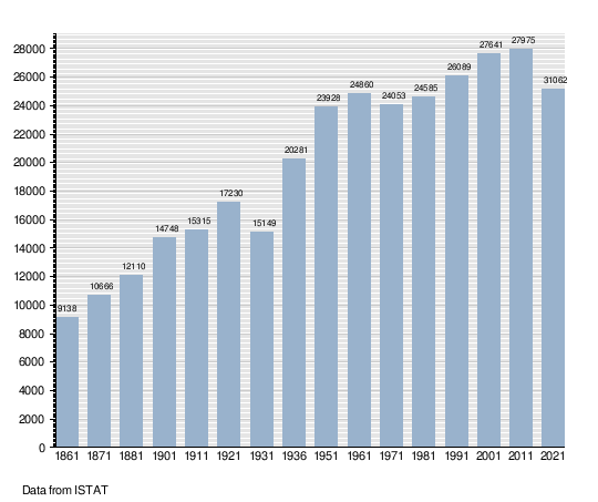
How Many People Live Here?
Here's a look at how Niscemi's population has changed over the years:
People from Other Countries
As of January 1, 2025, about 694 people living in Niscemi were from other countries. This was about 2.8% of everyone living there. The largest groups were:
- Romania: 381 people
- Tunisia: 173 people
- Morocco: 37 people
Learning and Culture
Libraries and Museums
Niscemi has a public library named after Mario Gori. It moved to a 19th-century building on Via IV Novembre in 2006. The library holds about 16,000 books. It also has many old newspapers.
The Civic Museum is located in an old Franciscan Friars Minor convent. It was created thanks to Totò Ravalli's idea. Over 30 years, many items were collected. The museum opened on October 7, 2018. It was a team effort by the Municipality, the Lions Club, and others.
The private library of Angelo Marsiano has about 4,000 books. It also contains notes, handwritten papers, and documents. The family of Angelo Marsiano decided to share these with the public. This building was very close to the edge of the cliff after the January 2026 landslide. Part of it was left hanging in the air. The first 350 books were saved in a careful operation.
Niscemi During World War II
During World War II, Niscemi was home to Ponte Olivo Airfield. This was a military airport used by the United States Twelfth Air Force. They used it during the war in Italy. After the war, the area was rebuilt. Today, there are no signs left of the wartime airfield.
The American Military Base

Today, Niscemi has a military radio station. It is called the U.S. Naval Radio Transmitter Facility (NRTF) Niscemi. This station helps with naval communication. Its tallest antenna is a very tall mast, 252 meters (827 feet) high.
Some local groups have protested against this U.S. Navy base. They have asked for it to be removed. Their concerns include possible health risks from electromagnetic radiation. They also worry about environmental damage. Some people have also expressed concerns about the use of armed drones in the Middle East. However, claims that armed drones are controlled from this base have not been confirmed. The new MUOS (Mobile User Objective System) at the base was installed to update communication equipment. It is not meant to communicate with unmanned flying drones. Some Niscemi residents felt that the government did not ask for their opinion before allowing the U.S. to use the location.
Famous People from Niscemi
- Mario Gori: A poet, writer, and storyteller (1926-1970).
- Angelo Marsiano: An Italian historian and essayist (1926-1993).
- Alice Mangione: An Italian sprinter, born in 1997.
- Simone Cilio: An Italian film composer, born in 1992.
See also
 In Spanish: Niscemi para niños
