Nitta Yuma, Mississippi facts for kids
Quick facts for kids
Nitta Yuma, Mississippi
|
|
|---|---|
 |
|

Nitta Yuma, Mississippi
Location in Mississippi

Nitta Yuma, Mississippi
Location in the United States
|
|
| Country | United States |
| State | Mississippi |
| County | Sharkey |
| Area | |
| • Total | 0.19 sq mi (0.50 km2) |
| • Land | 0.19 sq mi (0.50 km2) |
| • Water | 0.00 sq mi (0.00 km2) |
| Elevation | 112 ft (34 m) |
| Population
(2020)
|
|
| • Total | 8 |
| • Density | 41.67/sq mi (16.10/km2) |
| Time zone | UTC-6 (Central (CST)) |
| • Summer (DST) | UTC-5 (CDT) |
| Area code(s) | 662 |
| GNIS feature ID | 674927 |
Nitta Yuma is a small community in Sharkey County, Mississippi, United States. It is known as a census-designated place, which means it's an area the government counts for population. Nitta Yuma is located along U.S. Route 61, about four miles north of Anguilla.
The name "Nitta Yuma" comes from the Choctaw language. The Choctaw people lived in this area for thousands of years. Later, families like the Vicks and Willises started cotton farms here. Nitta Yuma was first officially counted as a census-designated place in the 2020 Census. At that time, its population was 8 people.
People in Nitta Yuma
In the 2020 Census, Nitta Yuma had a population of 8 people. Most of the residents, about 75%, were Black or African American. About 25% of the population was of Hispanic or Latino background.
Weather in Nitta Yuma
Nitta Yuma has a type of weather called a Humid subtropical climate. This means it has warm temperatures and rain spread out throughout the year. On climate maps, this climate is often shown as "Cfa."
Schools in Nitta Yuma
Students in Nitta Yuma attend schools that are part of the South Delta School District. The high school for the area is South Delta High School.
Images for kids
-
-

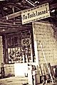
An old Nitta Yuma gas station. Picture taken while driving up 61 North
-