Noire River (Charlevoix) facts for kids
Quick facts for kids Rivière Noire |
|
|---|---|

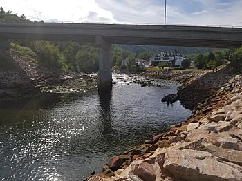
Bridge of route 138 passing over Noire River in Saint-Siméon.
|
|
| Country | Canada |
| Province | Quebec |
| Region | Capitale-Nationale |
| Regional County Municipality | Charlevoix-Est Regional County Municipality |
| City | Saint-Siméon |
| Physical characteristics | |
| Main source | Lac à l'Ours (Bear Lake) Saint-Siméon 549 m (1,801 ft) 47°57′38″N 70°13′59″W / 47.960535°N 70.23307°W |
| River mouth | St. Lawrence River Saint-Siméon 3 m (9.8 ft) 47°50′51″N 69°52′31″E / 47.8475°N 69.87527°E |
| Length | 30 km (19 mi) |
| Basin features | |
| Tributaries |
|
The Noire River is a river in Quebec, Canada. It flows into the big St. Lawrence River. This river is located in the Charlevoix-Est Regional County Municipality, near the town of Saint-Siméon. It's an important part of the local environment and economy.
Template:TOC limit=3
Contents
Where the River Flows
The Noire River is about 30 km (19 mi) long. It starts high up in the mountains at a place called "Lac à l'Ours" (Bear Lake). This lake is about 549 m (1,801 ft) above sea level.
From Bear Lake, the river flows through different areas. It passes through smaller lakes and over rapids. Eventually, it reaches the St. Lawrence River right near the village of Saint-Siméon. At its mouth, the river is only about 3 m (9.8 ft) above sea level.
Nearby Rivers and Land
The Noire River is surrounded by other rivers and land features.
- To the north, you'll find the Petite rivière Saguenay and the Saguenay River.
- To the east is the huge St. Lawrence River.
- To the south, there are rivers like the Noire South West River and the Malbaie River.
- To the west, you can find the Petit Saguenay River.
The river's path goes through forests and valleys. Some parts are easy to access, while others are more remote.
How People Use the River Area
The area around the Noire River is important for a few reasons.
Roads and Access
Two main roads help people get around this region.
- Route 138 runs along the shore of the St. Lawrence River. It crosses the Noire River near its mouth.
- Route 170 connects Saint-Siméon to Petit-Saguenay. This road serves the lower and middle parts of the river valley.
- Higher up in the valley, there are smaller forest roads. These are used for logging and for people who want to explore the wilderness.
Local Activities
The main activity in this area is forestry. This means cutting down trees for wood and other products. It's a big part of the local economy.
Recreational tourism is also very popular. People come here to enjoy nature. They might go fishing, hiking, or just relax by the river.
Winter on the River
During winter, the Noire River usually freezes over. This happens from early December until late March. However, it's generally safe to walk or play on the ice from mid-December to mid-March. Always be careful on ice!
River Name
The name "rivière Noire" means "Black River" in French. This name was officially recognized on December 5, 1968, by the Quebec Place Names Commission.
 | Jewel Prestage |
 | Ella Baker |
 | Fannie Lou Hamer |


