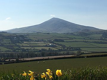
North Barrule facts for kids
Quick facts for kids North Barrule |
|
|---|---|
| Baarool Twoaie | |

North Barrule from the east
|
|
| Highest point | |
| Elevation | 561.4 m (1,842 ft) |
| Geography | |
| Country | United Kingdom |
| Crown dependency | Isle of Man |
North Barrule is a tall mountain on the Isle of Man. It is the second highest peak there, standing at 561.4 meters (about 1,842 feet) tall. Its name, Baarool Twoaie, means "lookout mountain" or "cairn mountain." From its top, you can see far across the island. On a clear day, you can even spot the coastlines of Ireland, Cumbria (in England), Wales, and Scotland!
About North Barrule
North Barrule is located in the northeastern part of the Isle of Man. It forms the edge of a ridge of hills. This mountain also marks the border between two areas called Lezayre and Maughold. It's a great place to see amazing views of the island's northern plain.
Climbing to the Top
Reaching the top of North Barrule is a fun hill walk. You don't need special climbing gear or skills. However, some paths might be a bit trickier.
Paths to the Summit
There are a couple of ways to hike up North Barrule:
- From the Black Hut:
- Start by climbing Clagh Ouyr. This short climb takes about 20 minutes.
- From there, you walk along the ridge of hills.
- This part of the walk to North Barrule's summit takes about 1.5 to 2 hours.
- The ground is mostly grassy and can be marshy (a bit wet) in some spots.
- From the Hibernia:
- Follow the footpath signs up a paved road.
- The path will then turn onto a rough track. This track winds steadily upwards to the left of the summit, between farm fields.
- Follow this track for about 40-50 minutes. You will then be facing the south slopes, above the Corrany Valley.
- You can also start from the valley floor. Turn off the A2 road after Dhoon Village where it says "The Corrany."
- Begin climbing through the fields. You will pass an old ruined farm building called Park Llewellyn on your left.
- A stone wall guides you upwards to the right. Follow this wall until you meet the ridge path from Clagh Ouyr.
- From there, the path to the summit is clear. This route is shorter but can be more challenging.
A Sad Event
On April 23, 1945, a large airplane called a Boeing B-17 Flying Fortress crashed into the east side of North Barrule. Sadly, all 31 people on board died. This was the most serious airplane accident ever to happen on the Isle of Man.
See also
 In Spanish: Barrule del Norte para niños
 | Calvin Brent |
 | Walter T. Bailey |
 | Martha Cassell Thompson |
 | Alberta Jeannette Cassell |

