North Sinai Governorate facts for kids
Quick facts for kids
North Sinai Governorate
|
|||
|---|---|---|---|
|
|||

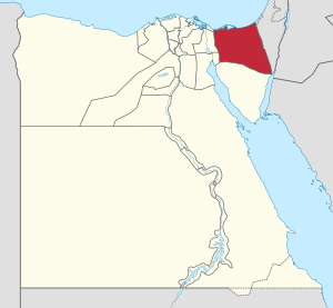
North Sinai Governorate on the map of Egypt
|
|||
| Country | |||
| Seat | Arish (capital) | ||
| Area | |||
| • Total | 27,574 km2 (10,646 sq mi) | ||
| Population
(January 2018)
|
|||
| • Total | 457,000 | ||
| • Density | 16.57/km2 (42.9/sq mi) | ||
| Time zone | UTC+2 (EET) | ||
The North Sinai Governorate is a special region in Egypt. It's like a state or province. Its main city, or capital, is called Arish. This area is located on the northern part of the Sinai Peninsula, which is a famous triangle-shaped piece of land.
The governorate covers a large area of about 27,574 square kilometers. As of January 2018, around 457,000 people lived here. This means it's not very crowded, with about 16 people per square kilometer.
Cities and Towns in North Sinai
This region has several important cities and towns. Each one plays a role in the life of the governorate.
El Arish: The Capital City
- El Arish is the biggest city and the capital of North Sinai. It's home to many people, with about 164,830 residents as of 2012. As the capital, it's the center for government and business in the area.
Other Important Towns
- Nekhel is another town in the governorate. It's located more towards the center of the Sinai Peninsula.
- Rafah is a town found near the border.
- Bir al-Abed is a town known for its history and location.
- Sheikh Zuweid is also located in the northern part of the governorate.
See also
- In Spanish: Gobernación de Sinaí del Norte para niños
Black History Month on Kiddle
African-American Labor Activists
 | William Lucy |
 | Charles Hayes |
 | Cleveland Robinson |

All content from Kiddle encyclopedia articles (including the article images and facts) can be freely used under Attribution-ShareAlike license, unless stated otherwise. Cite this article:
North Sinai Governorate Facts for Kids. Kiddle Encyclopedia.


