
North Watervliet Road–Paw Paw Lake Outlet Bridge facts for kids
Quick facts for kids North Watervliet Road–Paw Paw Lake Outlet Bridge |
|
|---|---|

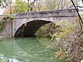
Photograph from a 1916 report by the Michigan State Highway Department
|
|
| Coordinates | 42°12′28″N 86°15′00″W / 42.20777°N 86.25005°W |
| Carries | |
| Crosses | Paw Paw Lake outlet |
| Locale | Watervliet Township, Michigan |
| Characteristics | |
| Total length | 45 feet (14 m) |
| Width | 24 feet (7.3 m) |
| Longest span | 40 feet (12 m) |
| Number of spans | 1 |
| History | |
| Closed | 2008 |

Location in Michigan

Location in the United States
|
|
| Built | 1916 |
| Demolished | 2008 |
| NRHP reference No. | 99001575 |
| Added to NRHP | December 17, 1999 |
The North Watervliet Road–Paw Paw Lake Outlet Bridge was a special bridge in Watervliet Township, Michigan. It was also known as Trunk Line Bridge No. 57. This bridge was an arch bridge that helped North Watervliet Road cross over the water flowing from Paw Paw Lake into the Paw Paw River. It was so important that it was listed on the National Register of Historic Places, which is a list of places important to American history. The bridge was taken down and replaced around 2008.
A Look Back: The Bridge's Story
The Michigan State Highway Department built this bridge in 1916. They used one of their standard designs. A builder named W. B. Rogers constructed the bridge. He was paid $5,269 for his work. The bridge had special plates that called it "Trunk Line Bridge No. 57." A picture of the finished bridge was even shown in a report from the highway department in 1916.
This bridge was considered very important for its design. Because of its unique features, it was added to the National Register of Historic Places on December 17, 1999. This list includes buildings, structures, and sites that are important to the history of the United States. Two other bridges in Berrien County, Michigan, were added on the same day.
In 2008, the old bridge was taken down. A new, modern bridge was built in its place. A company called L.W. Lamb, Inc. won the contract to do this work. The project cost about $770,181. It was planned to start in August 2008 and finish by May 2009.
How the Bridge Looked
The bridge was located north of Watervliet, Michigan. It was right where Paw Paw Lake flows into the Paw Paw River. The bridge was made of strong, reinforced concrete. It had a rounded, arch shape like a tunnel.
The bridge was about 45 feet (14 meters) long. Its main arch stretched 40 feet (12 meters) across the water. The sides of the bridge had solid concrete railings. These railings had six special recessed areas on each side. There were also metal guard rails at the corners. The bridge had identical plates at its north and south corners.
Images for kids
-
The North Watervliet Road–Paw Paw Lake Outlet Bridge in 2006, before it was replaced.

