Northeast Toulnustouc River facts for kids
Quick facts for kids Northeast Toulnustouc River |
|
|---|---|
| Native name | Rivière Toulnustouc Nord-Est |
| Country | Canada |
| Province | Quebec |
| Territory | Côte-Nord |
| Municipality | Lac-Walker |
| Physical characteristics | |
| Main source | Rivière-Mouchalagane 51°37′15″N 67°16′43″W / 51.620734°N 67.278510°W |
| River mouth | Toulnustouc River Lac Caron 50°54′36″N 67°41′45″W / 50.91°N 67.695833°W |
| Basin features | |
| NRC Id | EIHVK |
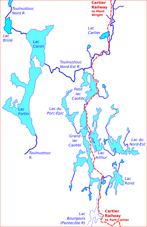
The Northeast Toulnustouc River (also known as Rivière Toulnustouc Nord-Est in French) is a river in Quebec, Canada. It flows into the Toulnustouc River. This river is located in the Lac-Walker area, which is part of the Sept-Rivières region in Côte-Nord. The Cartier Railway runs right next to the river for most of its journey.
Contents
Understanding the River's Name
The name "Toulnustouc" comes from the Innu language. Its exact meaning is not fully known, but there are a few ideas.
Some people think it means "elbow river" or "angled river." This idea matches an older name for the river, which was "Rivière du Coude" (Elbow River).
Other ideas from geography experts suggest it means "river where they make canoes" or "where canoes are needed." You might also see the name spelled in different ways, like Todnustook or Toulnoustouc.
In the late 1970s, the Innu people called it "Kuetutnustuku Shipu." This name means "river parallel to the Manicouagan River," which is another important river nearby.
Exploring the River's Path
The Northeast Toulnustouc River starts near a place called Rivière-Mouchalagane. It begins close to the Petit lac Manicouagan, an area that is often very high up, sometimes over 1,000 meters (about 3,280 feet) above sea level.
The river flows generally southeast, then turns south, and finally heads west. It eventually flows into Lac Caron, where it joins the main Toulnustouc River.
The Innu people, especially those from the Uashat Mak Mani-Utenam band, use parts of the Toulnustouc River area. This includes important lakes like Fortin Lake and Caron Lake, as well as the Northeast Toulnustouc River itself.
Another lake, Lake Arthur, which is in the Réserve faunique de Port-Cartier–Sept-Îles (a wildlife reserve), flows west into Grand lac Caotibi. This lake then drains north into Petit Lac Caotibi, which is a smaller river that feeds into the Northeast Toulnustouc River.
The River's Environment
The area around the Northeast Toulnustouc River is part of Quebec's ecological regions. As the river flows south, it passes through different types of forest areas. These include the Massif des monts Groulx and the Hautes collines du réservoir Manic 3, which are part of the boreal zone. This zone is known for its spruce trees and mossy ground.
The weather in this region is quite cold. The average temperature for the whole year is about -3 degrees Celsius (27 degrees Fahrenheit). July is the warmest month, with an average temperature of about 14 degrees Celsius (57 degrees Fahrenheit). January is the coldest, with temperatures dropping to about -20 degrees Celsius (-4 degrees Fahrenheit).
The Cartier Railway Along the River
The Cartier Railway is a very important railway line that runs alongside the Northeast Toulnustouc River for most of its length. Engineers who built the railway carefully planned its path.
They built the tracks along the rocky edges of the river. This was a smart choice because these areas are well-drained and stay safely above the water level, even during spring floods.
The railway was designed with gentle slopes. Trains traveling north have a maximum uphill slope of 1.35%, and trains going south have an even gentler slope of 0.4%. These gentle slopes allow southbound trains to travel the entire 259 miles (about 417 kilometers) from Mont Wright to Port-Cartier without needing to stop.
To avoid problems with the ground freezing and thawing (called frost heaves), the railway tracks are often cut into the sides of the river valleys, rather than being placed on the valley floors. At one point, about 154.8 miles along the line, the railway is a remarkable 300 feet (about 91 meters) above the river!
Lakes in the River Basin
Many lakes are part of the Northeast Toulnustouc River's water system, especially in the southern part of its basin. Some of these lakes are found within the Port-Cartier–Sept-Îles Wildlife Reserve.
Here are some of the notable lakes in this area:
| Lake | Coordinates | Map Link |
|---|---|---|
| Lac Rond | 50°40′17″N 67°27′32″W / 50.6714°N 67.4589°W | EHXHT |
| Lac du Nord-Est | 50°43′57″N 67°27′19″W / 50.7325°N 67.4553°W | EHKYC |
| Lac Arthur | 50°46′01″N 67°31′57″W / 50.7669°N 67.5325°W | EFJFB |
| Lac du Porc-Épic | 50°48′58″N 67°37′50″W / 50.8161°N 67.6306°W | EHSJQ |
| Grand lac Caotibi | 50°43′59″N 67°33′14″W / 50.7331°N 67.5539°W | EFTJO |
| Petit Lac Caotibi | 50°51′57″N 67°32′30″E / 50.8658°N 67.5417°E | EJBIB |
 | Ernest Everett Just |
 | Mary Jackson |
 | Emmett Chappelle |
 | Marie Maynard Daly |


