Northeim (district) facts for kids
Quick facts for kids
Northeim
|
||
|---|---|---|
|
||
| Country | ||
| State | Lower Saxony | |
| Capital | Northeim | |
| Area | ||
| • Total | 1,267 km2 (489 sq mi) | |
| Population | ||
| • Total | 144.044 | |
| • Density | 0.11369/km2 (0.29445/sq mi) | |
| Time zone | UTC+1 (CET) | |
| • Summer (DST) | UTC+2 (CEST) | |
| Vehicle registration | NOM, EIN, GAN | |
| Website | landkreis-northeim.de | |
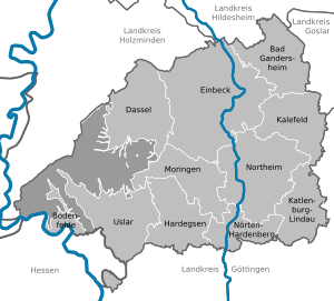
Northeim is a special kind of area in Lower Saxony, Germany, called a district. Think of it like a county in some other countries. It's a place where many towns and villages work together.
This district is found in the beautiful Weserbergland mountains. The Weser River forms the western edge of the district. Another important river, the Leine, flows right through the middle of Northeim, from the south to the north.
Towns and Communities in Northeim
The Northeim district is made up of several towns and smaller communities. Each of these places has its own unique history and character. They all work together as part of the larger district.
Here are the main towns and communities you can find in the Northeim district:
Major Towns
- Bad Gandersheim
- Dassel
- Einbeck
- Hardegsen
- Moringen
- Northeim
- Uslar
Local Communities
- Bodenfelde
- Kalefeld
- Katlenburg-Lindau
- Nörten-Hardenberg
See also
 In Spanish: Distrito de Northeim para niños
Black History Month on Kiddle
Famous African-American Activists:
 | William L. Dawson |
 | W. E. B. Du Bois |
 | Harry Belafonte |

All content from Kiddle encyclopedia articles (including the article images and facts) can be freely used under Attribution-ShareAlike license, unless stated otherwise. Cite this article:
Northeim (district) Facts for Kids. Kiddle Encyclopedia.


