O'Haver Lake facts for kids
Quick facts for kids O'Haver Lake |
|
|---|---|
| Lake O'Haver | |

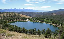
A view of the lake from Forest Road 200
|
|
| Location | Chaffee County, Colorado |
| Coordinates | 38°25′38″N 106°08′46″W / 38.42722°N 106.14611°W |
| Etymology | Named for former Chaffee County Commissioner R.T. O'Haver. |
| Primary inflows | Gray's Creek by means of the O'Haver filler ditch |
| Primary outflows | Ditch back to Gray's Creek |
| Basin countries | United States |
| Managing agency | Upper Arkansas Water Conservancy District |
| Built | 1949 |
| Surface area | 15 acres (6.1 hectares) |
| Water volume | 186.7 acre-feet (230,300 cubic metres) |
| Surface elevation | 9,130 feet (2,780 meters) |
| Frozen | Freezes in winter |
O'Haver Lake is a beautiful reservoir, which is a type of man-made lake. It is located in Chaffee County, Colorado, within the huge San Isabel National Forest. This lake was created in 1949. It was named after R.T. O'Haver, who was a commissioner for Chaffee County.
The lake is found about two miles from U.S. Highway 50, a major road, just west of Poncha Pass. You can reach O'Haver Lake and its nearby campground by taking Forest Road 200. This road is also known as Marshall Pass Road. The actual Marshall Pass is about twelve miles further up this road from the lake.
Visiting O'Haver Lake
O'Haver Lake is a popular spot for outdoor activities. It is known for its peaceful setting and the chance to enjoy nature. The lake is surrounded by tall trees like ponderosa pines and aspens.
The Campground
The United States Forest Service manages the O'Haver Lake Campground. This campground is right next to the lake, making it easy to enjoy the water. It has 31 campsites where people can set up tents or park RVs. The campground is very popular, especially on weekends, so it's a good idea to plan ahead if you want to visit.
Fishing at the Lake
O'Haver Lake is a great place for fishing. The lake is regularly stocked with trout, which means fish are added to it so there are always plenty for anglers. Fishing is a fun way to spend time by the water and enjoy the quiet surroundings.
Winter at O'Haver Lake
During the colder months, O'Haver Lake freezes over. This creates a different kind of natural beauty. While some activities might change, the area remains a scenic spot in the winter landscape.


