Ocamonte facts for kids
Quick facts for kids
Ocamonte
|
|||
|---|---|---|---|
|
Municipality and town
|
|||
|
|||

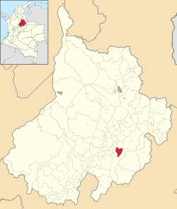
Location of the municipality and town of Ocamonte in the Santander Department of Colombia.
|
|||
| Country | |||
| Department | Santander Department | ||
| Area | |||
| • Total | 84 km2 (32 sq mi) | ||
| Elevation | 746 m (2,448 ft) | ||
| Time zone | UTC-5 (Colombia Standard Time) | ||
Ocamonte is a charming town and a municipality located in the Santander Department in northeastern Colombia. A municipality is like a local government area, similar to a county or district. Ocamonte is known for its beautiful natural scenery and fertile lands.
Contents
Getting to Ocamonte
Ocamonte is quite easy to reach, especially from the nearby city of San Gil. It's only about an hour's drive on a paved road. This makes it a great spot for a day trip or a short visit.
There are three main ways to get to Ocamonte:
- From San Gil: You can take the paved road that crosses the "Palenque" bridge.
- From Charalá: There's an unpaved road connecting Charalá to Ocamonte.
- From Valle de San José: Another route leads from Valle de San José to Ocamonte.
Exploring Ocamonte's Nature
Ocamonte is a wonderful place for nature lovers and adventurers. Since it's close to San Gil, which is known as the "Tourism Capital" of the region, Ocamonte has become a popular destination.
The Soap Hill Adventure
One of the best things to do in Ocamonte is to hike up the Cerro de La Jabonera, also known as the Soap Hill. This mountain stands tall at about 2,200 meters (7,218 feet) above sea level. It's the highest mountain in the area!
At the top of the Soap Hill, you'll find a monument dedicated to the Virgin Mary. But even if you're not visiting for religious reasons, the view from up there is absolutely amazing. You can see a wide, panoramic landscape that includes Ocamonte itself, along with the nearby municipalities of Charalá and Páramo. You can also spot their rural areas and even distant peaks like Russia and Westfall Sugar Loaf. It's a perfect spot for taking incredible photos!
Ocamonte's Surroundings
Ocamonte shares its borders with several other interesting places. To the north, it borders San José Valley. To the south and west, it borders Charalá. To the east, it borders Coromoro.
The town of Ocamonte itself sits at an elevation of about 1,408 meters (4,619 feet). The climate in the municipality can change quite a bit because the land ranges in height from 1,300 meters (4,265 feet) to 2,300 meters (7,546 feet). This means you might experience different temperatures depending on where you are in the area.
Did you know that the exact opposite side of the Earth from Ocamonte is located in Jakarta, the capital city of Indonesia? This opposite point is called an antipode.
What Ocamonte Produces
The land around Ocamonte is very rich and fertile. This means that farmers can grow many different kinds of crops here. The main crops that thrive in Ocamonte include:
- Coffee: A popular drink enjoyed around the world.
- Sugar Cane: Used to make sugar and other sweet products.
- Corn: A versatile grain used in many foods.
These crops are very important to the local economy and help support the people living in Ocamonte.
See also
 In Spanish: Ocamonte para niños
 | Valerie Thomas |
 | Frederick McKinley Jones |
 | George Edward Alcorn Jr. |
 | Thomas Mensah |


