Olaya Herrera facts for kids
Quick facts for kids
Olaya Herrera
|
|
|---|---|
|
Municipality and town
|
|

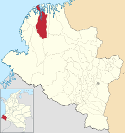
Location of the municipality and town of Olaya Herrera in the Nariño Department of Colombia.
|
|
| Country | |
| Department | Nariño Department |
| Population
(2020 est.)
|
|
| • Total | 33,132 |
| Time zone | UTC-5 (Colombia Standard Time) |
Olaya Herrera is a town and a special area called a municipality in the Nariño Department of Colombia. Think of a municipality like a county or a local government area. This place is named after Enrique Olaya Herrera, who was a former President of Colombia. The main town, or "municipal seat," of Olaya Herrera is known as Bocas de Satinga.
Contents
Discovering Olaya Herrera
Olaya Herrera is located in the southwestern part of Colombia. It is part of the Nariño Department, which is one of the 32 departments that make up Colombia. The department is known for its diverse landscapes, from Pacific coastlines to Andean mountains.
What is a Municipality?
A municipality is a local government area. It includes a main town and the surrounding rural areas. Olaya Herrera is one of many municipalities in Colombia. It has its own local government that helps manage the area.
Who was Enrique Olaya Herrera?
The town and municipality are named after Enrique Olaya Herrera. He was a very important person in Colombian history. He served as the President of Colombia from 1930 to 1934. Naming the town after him honors his contributions to the country.
Climate and Weather
Olaya Herrera experiences a tropical rainforest climate. This means it is warm all year round and gets a lot of rain. The weather is usually hot and humid. This type of climate is common in areas near the Equator.
Understanding Tropical Rainforest Climate
A tropical rainforest climate, often called Af in the Köppen climate classification system, means there's heavy rainfall throughout the year. There isn't a dry season. This constant warmth and rain create lush, green environments. It's perfect for many types of plants and animals.
| Climate data for Bocas de Satinga | |||||||||||||
|---|---|---|---|---|---|---|---|---|---|---|---|---|---|
| Month | Jan | Feb | Mar | Apr | May | Jun | Jul | Aug | Sep | Oct | Nov | Dec | Year |
| Mean daily maximum °C (°F) | 28.6 (83.5) |
29.5 (85.1) |
29.9 (85.8) |
29.8 (85.6) |
29.5 (85.1) |
29.6 (85.3) |
29.4 (84.9) |
29.2 (84.6) |
29.0 (84.2) |
28.3 (82.9) |
28.4 (83.1) |
28.8 (83.8) |
29.2 (84.5) |
| Daily mean °C (°F) | 25.5 (77.9) |
25.9 (78.6) |
26.3 (79.3) |
26.3 (79.3) |
26.2 (79.2) |
26.1 (79.0) |
26.0 (78.8) |
26.0 (78.8) |
25.8 (78.4) |
25.5 (77.9) |
25.6 (78.1) |
25.6 (78.1) |
25.9 (78.6) |
| Mean daily minimum °C (°F) | 22.5 (72.5) |
22.4 (72.3) |
22.7 (72.9) |
22.9 (73.2) |
23.0 (73.4) |
22.6 (72.7) |
22.6 (72.7) |
22.8 (73.0) |
22.6 (72.7) |
22.8 (73.0) |
22.8 (73.0) |
22.5 (72.5) |
22.7 (72.8) |
| Average rainfall mm (inches) | 330 (13.0) |
293 (11.5) |
257 (10.1) |
348 (13.7) |
502 (19.8) |
489 (19.3) |
320 (12.6) |
264 (10.4) |
346 (13.6) |
329 (13.0) |
254 (10.0) |
231 (9.1) |
3,963 (156.1) |
| Source: Climate-Data.org | |||||||||||||
See also
 In Spanish: Olaya Herrera para niños
 | Emma Amos |
 | Edward Mitchell Bannister |
 | Larry D. Alexander |
 | Ernie Barnes |

