
Ontario Highway 28 facts for kids
Quick facts for kids
|
||||||||||
|---|---|---|---|---|---|---|---|---|---|---|
| Lua error in Module:Infobox_road/map at line 15: attempt to index field 'wikibase' (a nil value). | ||||||||||
| Route information | ||||||||||
| Maintained by the Ministry of Transportation of Ontario | ||||||||||
| Length | 162.6 km (101.0 mi) | |||||||||
| Major junctions | ||||||||||
| South end | ||||||||||
| East end | ||||||||||
| Highway system | ||||||||||
|
||||||||||

Ontario Highway 28 is a major road in Ontario, Canada. It's a "provincial highway," meaning it's managed by the province. This highway stretches for about 162.6 kilometers (101 miles). It travels from the southwest part of Ontario towards the northeast.
Contents
About Highway 28
Highway 28 starts near Peterborough. Its southern end connects with Highway 7. This meeting point is about 7 kilometers (4.3 miles) east of Peterborough. The highway then heads northeast through different towns.
Where Does Highway 28 End?
The highway finishes its journey in the town of Denbigh. Here, it meets another important road, Highway 41. So, Highway 28 connects these two main highways.
Changes to the Highway Over Time
Highway 28 used to be longer. It once went further south from Peterborough. This older part of the highway reached into Northumberland County. However, in 1997 and 1998, things changed. The southern 63 kilometers (39 miles) of the highway were given to local towns to manage. This means the province no longer takes care of that section.
Images for kids
-
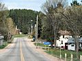
The north-eastern end of Highway 28 in Denbigh
-
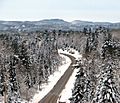
Highway 28 east of McArthur Mills


