
Ontario Highway 62 facts for kids
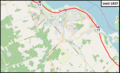
Ontario Highway 62 is a special road in the province of Ontario, Canada. It's like a long path that connects different towns and areas. This highway starts in Prince Edward County and travels north through Hastings County. It finally ends in Hastings Highlands, where it joins up with another road called Highway 127. Along its way, Highway 62 passes through interesting places like Belleville, Madoc, and Bancroft. It's quite a long journey, stretching for about 165.8 kilometers (which is about 103 miles)!
Contents
What is Ontario Highway 62?
Ontario Highway 62 is a "provincial" highway. This means it's a main road managed by the government of Ontario. These highways help people travel across the province. They connect cities, towns, and rural areas. Highway 62 is an important route for many communities in eastern Ontario.
Where Does Highway 62 Go?
Highway 62 begins its journey in Prince Edward County. Its starting point is at Highway 33. From there, it heads north, crossing into Hastings County.
As it travels north, Highway 62 goes through several towns. You might see signs for Belleville, a larger city along the route. Further north, it passes through the towns of Madoc and Bancroft. These towns are known for their beautiful natural surroundings.
The highway continues its path until it reaches Hastings Highlands. Here, Highway 62 doesn't just end. Instead, it merges with another provincial road, Highway 127. This means the two highways become one road for a while.
How Long is Highway 62?
Highway 62 is a fairly long road. It stretches for about 165.8 kilometers. If you prefer miles, that's roughly 103 miles. This length makes it an important connection for many communities. It helps people travel for work, school, or just to visit friends and family.
Images for kids
-
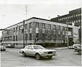
Highway 62 at Bridge Street in Belleville
-
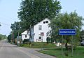
Highway 62 passing through Bannockburn
-
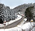
Highway 62 north of Bancroft
-
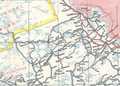
1937–38 Ontario road map, showing the section of Highway 62 between Barry's Bay and Bonnechere that was never built
-
Animation of highway routes near Pembroke, from 1936 to now


