
Oparau River facts for kids
Quick facts for kids Oparau River |
|
|---|---|
| Country | New Zealand |
| Physical characteristics | |
| River mouth | Kawhia Harbour |
| Length | 17 km (11 mi) |
.jpg)
The Oparau River is a beautiful river located in the Waikato Region of New Zealand's North Island. It is about 17 kilometers (11 miles) long. The river starts in the Pirongia Forest Park and flows towards the southwest. It eventually empties into the Kawhia Harbour, which is a large natural harbor. This meeting point is about 5 kilometers (3 miles) east of the town of Kawhia.
Contents
Meaning Behind the Name Oparau
The name Ōparau has a special meaning in the Māori language. The New Zealand Ministry for Culture and Heritage helps us understand these meanings. One translation for Ōparau is "place of many fortified villages." A pā was a traditional Māori village, often built on a hilltop for defense. Another possible meaning for Ōparau is "place of falsehood." These names tell us a little about the history and culture of the area.
The Journey of the Oparau River
Starting Point: Pirongia Forest Park
The Oparau River begins its journey high up in the Pirongia Forest Park. This park is a protected area known for its native forests and wildlife. The water collects from streams and rainfall within the park. It then starts flowing downhill, gathering more water as it goes.
Flowing Towards Kawhia Harbour
As the river flows, it travels through different landscapes. It passes through valleys and open areas before reaching the coast. The river's path is generally southwest. This direction takes it directly towards the large Kawhia Harbour.
Reaching Kawhia Harbour
The Kawhia Harbour is an important natural feature on the west coast of the North Island. It is a sheltered body of water connected to the Tasman Sea. The Oparau River is one of several rivers that flow into this harbor. The harbor is known for its history and natural beauty.
Images for kids
-
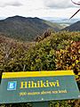
Ōpārau valley and Kawhia Harbour from Hihikiwi summit in 2015

