kids encyclopedia robot

Operation Crosstie facts for kids

Kids Encyclopedia Facts
Quick facts for kids
Operation Crosstie
Crosstie Buggy 001.jpg
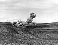
Crosstie Buggy, a row excavation test using five detonations in a row
Information
Country United States
Test site
  • Central Nevada
  • near Farmington, New Mexico
  • NTS Area 12, Rainier Mesa
  • NTS Area 19, 20, Pahute Mesa
  • NTS Area 30, Dome Mountain
  • NTS Areas 5, 11, Frenchman Flat
  • NTS, Areas 1–4, 6–10, Yucca Flat
Period 1967–1968
Number of tests 48
Test type cratering, underground shaft, tunnel
Max. yield 1.3 megatonnes of TNT (5.4 PJ)
Navigation
Previous test series Operation Latchkey
Next test series Operation Bowline

Operation Crosstie was a series of 48 nuclear tests conducted by the United States in 1967–1968 at the Nevada Test Site. These tests followed the Operation Latchkey series and preceded the Operation Bowline series.

Gasbuggy

The blast designated Gasbuggy involved an underground detonation, intended to stimulate production of natural gas by cracking the rock in the underground formation of its deposit. The test proceeded as expected, but not only did the production not increase as much as expected, but the customers also refused to buy gas contaminated with traces of radioisotopes.

Buggy

Buggy was a Plowshare test designed to excavate a channel. It was a simultaneous detonation of 5 devices, placed 150 feet (46 m) apart and 150 feet (46 m) below the surface that resulted in a channel 300 feet (91 m) wide, 900 feet long, and 80 feet (24 m) deep . Or 65 feet deep and 254 feet wide, according to declassified U.S. film.

The USSR conducted a similar salvo-test to investigate the use of nuclear explosions in the construction of the Pechora–Kama Canal project. On March 23, 1971, three simultaneously detonated 15 kiloton underground nuclear charges were exploded in the Taiga test.

Faultless

Project Faultless Plaque
Plaque at the Project Faultless test site.

The Faultless test was a calibration test conducted in a mine cavity 3,200 feet beneath the Hot Creek Valley near Tonopah, Nevada, with a yield of around 1 megaton. This test was conducted to see if the land was fit for testing a 5 megaton thermonuclear warhead for the Spartan missile. The test failed because of the large degree of faulting that resulted in the area around the test. It was decided that the land was unfit for multi-megaton nuclear tests, so a similar calibration test was conducted at Amchitka Island, Alaska, in the fall of 1969 during Operation Mandrel.

The 8 foot diameter steel pipe that was used to place the bomb remains at the test site. The top of the pipe was originally flush with the surface; however, the ground sank by nine feet following the explosion. A plaque is mounted on the exposed pipe to commemorate the event.

Table of detonations

The United States's Crosstie nuclear test series was a group of 48 nuclear tests conducted in 1967–1968. These tests followed the Operation Latchkey series and preceded the Operation Bowline series.

United States' Crosstie series tests and detonations
Name Date time (UT) Local time zone Location Elevation + height Delivery
Purpose
Device Yield Fallout References Notes
Vito July 14, 1967 13:30:00.08 PST (–8 hrs)
NTS Area U10ab 37°09′55″N 116°02′45″W / 37.1652°N 116.0458°W / 37.1652; -116.0458 (Vito) 1,278 m (4,193 ft) – 90.83 m (298.0 ft) underground shaft,
safety experiment
less than 20 kt
Stanley July 27, 1967 13:00:00.12 PST (–8 hrs)
NTS Area U10g 37°08′56″N 116°02′58″W / 37.14879°N 116.04938°W / 37.14879; -116.04938 (Stanley) 1,265 m (4,150 ft) – 483.72 m (1,587.0 ft) underground shaft,
weapons development
22 kt Venting detected, 37 Ci (1,400 GBq)
Gibson August 4, 1967 14:00:00.04 PST (–8 hrs)
NTS Area U3ew 37°01′28″N 116°00′47″W / 37.02431°N 116.01315°W / 37.02431; -116.01315 (Gibson) 1,186 m (3,891 ft) – 240.76 m (789.9 ft) underground shaft,
weapons development
1.5 kt
Washer August 10, 1967 14:10:00.0 PST (–8 hrs)
NTS Area U10r 37°09′24″N 116°02′53″W / 37.15665°N 116.04815°W / 37.15665; -116.04815 (Washer) 1,271 m (4,170 ft) – 467.41 m (1,533.5 ft) underground shaft,
weapons development
less than 20 kt Venting detected, 0.5 Ci (19 GBq)
Bordeaux August 18, 1967 20:12:30.04 PST (–8 hrs)
NTS Area U3dr 37°00′44″N 116°02′14″W / 37.01219°N 116.03717°W / 37.01219; -116.03717 (Bordeaux) 1,183 m (3,881 ft) – 332.02 m (1,089.3 ft) underground shaft,
weapons development
18 kt
Lexington August 24, 1967 13:30:00.0 PST (–8 hrs)
NTS Area U2bm 37°09′46″N 116°04′30″W / 37.16266°N 116.07504°W / 37.16266; -116.07504 (Lexington) 1,310 m (4,300 ft) – 227.69 m (747.0 ft) underground shaft,
weapons development
800 t Venting detected, 1.1 kCi (41 TBq)
Door Mist August 31, 1967 16:30:00.04 PST (–8 hrs)
NTS Area U12g.07 37°10′39″N 116°12′35″W / 37.17751°N 116.20982°W / 37.17751; -116.20982 (Door Mist) 2,295 m (7,530 ft) – 435.86 m (1,430.0 ft) tunnel,
weapon effect
20 kt Venting detected off site, 690 kCi (26,000 TBq)
Yard September 7, 1967 13:45:00.0 PST (–8 hrs)
NTS Area U10af 37°09′11″N 116°03′13″W / 37.15301°N 116.0536°W / 37.15301; -116.0536 (Yard) 1,270 m (4,170 ft) – 520.6 m (1,708 ft) underground shaft,
weapons development
22 kt Venting detected, 0.3 Ci (11 GBq)
Gilroy September 15, 1967 17:30:00.04 PST (–8 hrs)
NTS Area U3ex 37°02′05″N 116°01′18″W / 37.03484°N 116.0216°W / 37.03484; -116.0216 (Gilroy) 1,191 m (3,907 ft) – 240.63 m (789.5 ft) underground shaft,
weapons development
less than 20 kt Venting detected
Marvel September 21, 1967 20:45:00.0 PST (–8 hrs)
NTS Area U10ds1 37°09′57″N 116°02′21″W / 37.16595°N 116.03929°W / 37.16595; -116.03929 (Marvel) 1,288 m (4,226 ft) – 174.35 m (572.0 ft) underground shaft,
peaceful research
2.2 kt Venting detected on site, 27 Ci (1,000 GBq) Plowshare – explore underground phenomena concerning emplacement techniques.
Zaza September 27, 1967 17:00:00.04 PST (–8 hrs)
NTS Area U4c 37°05′56″N 116°03′17″W / 37.09899°N 116.05475°W / 37.09899; -116.05475 (Zaza) 1,240 m (4,070 ft) – 667 m (2,188 ft) underground shaft,
weapons development
160 kt
Lanpher October 18, 1967 14:30:00.08 PST (–8 hrs)
NTS Area U2x 37°06′56″N 116°03′31″W / 37.11554°N 116.05848°W / 37.11554; -116.05848 (Lanpher) 1,255 m (4,117 ft) – 714.2 m (2,343 ft) underground shaft,
weapons development
160 kt Venting detected, 5 Ci (180 GBq)
Cognac October 25, 1967 14:30:00.14 PST (–8 hrs)
NTS Area U3fm 37°02′59″N 116°02′26″W / 37.04975°N 116.04044°W / 37.04975; -116.04044 (Cognac) 1,202 m (3,944 ft) – 240.39 m (788.7 ft) underground shaft,
weapons development
less than 20 kt Venting detected on site, 0.064 Ci (2.4 GBq)
Sazerac October 25, 1967 14:30:00.06 PST (–8 hrs)
NTS Area U3fa 37°01′54″N 116°01′38″W / 37.0316°N 116.02709°W / 37.0316; -116.02709 (Sazerac) 1,191 m (3,907 ft) – 301.34 m (988.6 ft) underground shaft,
weapons development
9 kt Venting detected, 0.1 Ci (3.7 GBq)
Worth October 25, 1967 14:45:00.08 PST (–8 hrs)
NTS Area U10ag 37°09′23″N 116°02′58″W / 37.15629°N 116.04946°W / 37.15629; -116.04946 (Worth) 1,269 m (4,163 ft) – 197 m (646 ft) underground shaft,
weapons development
less than 20 kt Venting detected, 40 Ci (1,500 GBq)
Cobbler November 8, 1967 15:00:00.04 PST (–8 hrs)
NTS Area U7u 37°05′30″N 116°02′12″W / 37.09176°N 116.03667°W / 37.09176; -116.03667 (Cobbler) 1,242 m (4,075 ft) – 667.12 m (2,188.7 ft) underground shaft,
weapons development
20 kt
Polka December 6, 1967 13:00:00.0 PST (–8 hrs)
NTS Area U10ai 37°09′33″N 116°03′14″W / 37.15922°N 116.05382°W / 37.15922; -116.05382 (Polka) 1,273 m (4,177 ft) – 195.01 m (639.8 ft) underground shaft,
weapons development
200 t Venting detected, 380 Ci (14,000 GBq)
Gasbuggy December 10, 1967 19:30:00.14 MST (–7 hrs)
near Farmington, New Mexico 36°40′40″N 107°12′32″W / 36.6778°N 107.2089°W / 36.6778; -107.2089 (Gasbuggy) 2,179 m (7,149 ft) – 1,290 m (4,230 ft) underground shaft,
peaceful research
29 kt Project Plowshare – stimulate gas production in a low permeability field.
Stilt December 15, 1967 15:00:00.04 PST (–8 hrs)
NTS Area U3fh 37°02′12″N 116°00′10″W / 37.03666°N 116.00273°W / 37.03666; -116.00273 (Stilt) 1,204 m (3,950 ft) – 332.43 m (1,090.6 ft) underground shaft,
weapons development
2 kt
Hupmobile January 18, 1968 16:30:00.13 PST (–8 hrs)
NTS Area U2y 37°08′44″N 116°04′00″W / 37.14554°N 116.06654°W / 37.14554; -116.06654 (Hupmobile) 1,287 m (4,222 ft) – 246.89 m (810.0 ft) underground shaft,
weapon effect
7.4 kt Venting detected off site, 120 kCi (4,400 TBq)
Staccato January 19, 1968 15:00:00.0 PST (–8 hrs)
NTS Area U10ah 37°09′23″N 116°03′17″W / 37.15633°N 116.05475°W / 37.15633; -116.05475 (Staccato) 1,272 m (4,173 ft) – 443.48 m (1,455.0 ft) underground shaft,
weapons development
50 kt Venting detected, 8 Ci (300 GBq)
Faultless January 19, 1968 18:15:00.08 PST (–8 hrs)
Central Nevada 38°38′03″N 116°12′58″W / 38.63421°N 116.21622°W / 38.63421; -116.21622 (Faultless) 1,866 m (6,122 ft) – 980 m (3,220 ft) underground shaft,
weapon effect
1 Mt A calibration test for a 5 Mt Spartan test; due to geological failure (local faulting on the site), test Adagio cancelled, and moved to Amchitka Island in Alaska; see Milrow and Cannikin.
Brush January 24, 1968 15:00:00.04 PST (–8 hrs)
NTS Area U3eq 37°02′34″N 116°00′53″W / 37.04277°N 116.01466°W / 37.04277; -116.01466 (Brush) 1,199 m (3,934 ft) – 118.3 m (388 ft) underground shaft,
weapons development
less than 20 kt Venting detected on site, 0.00002 Ci (0.00074 GBq)
Cabriolet January 26, 1968 16:00:00.11 PST (–8 hrs)
NTS Area U20l 37°16′51″N 116°30′56″W / 37.28079°N 116.51544°W / 37.28079; -116.51544 (Cabriolet) 1,862 m (6,109 ft) – 51.82 m (170.0 ft) cratering,
peaceful research
2.3 kt Venting detected off site, 220 kCi (8,100 TBq) Project Plowshare – cratering mechanics in hard, dry rock, and radionuclide dispersal.
Mallet January 31, 1968 15:30:00.04 PST (–8 hrs)
NTS Area U3fv 37°00′04″N 116°00′36″W / 37.00098°N 116.01002°W / 37.00098; -116.01002 (Mallet) 1,177 m (3,862 ft) – 240.27 m (788.3 ft) underground shaft,
weapons development
4 kt
Torch February 21, 1968 15:00:00.04 PST (–8 hrs)
NTS Area U3fj 37°02′30″N 116°00′10″W / 37.04161°N 116.00269°W / 37.04161; -116.00269 (Torch) 1,210 m (3,970 ft) – 240.55 m (789.2 ft) underground shaft,
weapons development
less than 20 kt
Knox February 21, 1968 15:30:00.0 PST (–8 hrs)
NTS Area U2at 37°06′59″N 116°03′18″W / 37.11633°N 116.05508°W / 37.11633; -116.05508 (Knox) 1,253 m (4,111 ft) – 644.8 m (2,115 ft) underground shaft,
weapons development
200 kt Venting detected, 160 Ci (5,900 GBq)
Dorsal Fin February 29, 1968 17:08:30.04 PST (–8 hrs)
NTS Area U12e.10 37°11′04″N 116°12′44″W / 37.18456°N 116.21232°W / 37.18456; -116.21232 (Dorsal Fin) 2,260 m (7,410 ft) – 410.06 m (1,345.3 ft) tunnel,
weapon effect
20 kt
Russet March 5, 1968 15:30:00.04 PST (–8 hrs)
NTS Area U6a 36°58′12″N 116°03′24″W / 36.97002°N 116.05653°W / 36.97002; -116.05653 (Russet) 1,170 m (3,840 ft) – 119.79 m (393.0 ft) underground shaft,
weapons development
less than 20 kt Venting detected on site, 29 Ci (1,100 GBq)
Buggy - 1 March 12, 1968 17:04:00.11 PST (–8 hrs)
NTS Area U30a 37°00′27″N 116°22′15″W / 37.00745°N 116.37086°W / 37.00745; -116.37086 (Buggy - 1) 1,560 m (5,120 ft) – 50.29 m (165.0 ft) cratering,
peaceful research
1.1 kt Venting detected off site, 1.2 MCi (44 PBq) Simultaneous, separate holes. Project Plowshare – row charge experiment.
Buggy - 2 March 12, 1968 17:04:00.11 PST (–8 hrs)
NTS Area U30b 37°00′27″N 116°22′17″W / 37.00759°N 116.37133°W / 37.00759; -116.37133 (Buggy - 2) 1,560 m (5,120 ft) – 50.29 m (165.0 ft) cratering,
peaceful research
1.1 kt Venting detected off site Simultaneous, separate holes. Project Plowshare – row charge experiment.
Buggy - 3 March 12, 1968 17:04:00.11 PST (–8 hrs)
NTS Area U30c 37°00′28″N 116°22′19″W / 37.00773°N 116.37181°W / 37.00773; -116.37181 (Buggy - 3) 1,561 m (5,121 ft) – 50.29 m (165.0 ft) cratering,
peaceful research
1.1 kt Venting detected off site Simultaneous, separate holes. Project Plowshare – row charge experiment.
Buggy - 4 March 12, 1968 17:04:00.11 PST (–8 hrs)
NTS Area U30d 37°00′28″N 116°22′20″W / 37.00788°N 116.37229°W / 37.00788; -116.37229 (Buggy - 4) 1,560 m (5,120 ft) – 50.29 m (165.0 ft) cratering,
peaceful research
1.1 kt Venting detected off site Simultaneous, separate holes. Project Plowshare – row charge experiment.
Buggy - 5 March 12, 1968 17:04:00.11 PST (–8 hrs)
NTS Area U30e 37°00′29″N 116°22′22″W / 37.00803°N 116.37277°W / 37.00803; -116.37277 (Buggy - 5) 1,560 m (5,120 ft) – 50.29 m (165.0 ft) cratering,
peaceful research
1.1 kt Venting detected off site Simultaneous, separate holes. Project Plowshare – row charge experiment.
Pommard March 14, 1968 15:19:00.06 PST (–8 hrs)
NTS Area U3ee 37°02′52″N 116°00′42″W / 37.0477°N 116.01155°W / 37.0477; -116.01155 (Pommard) 1,208 m (3,963 ft) – 209.1 m (686 ft) underground shaft,
weapons development
1.5 kt
Stinger March 22, 1968 15:00:00.04 PST (–8 hrs)
NTS Area U19l 37°19′57″N 116°18′42″W / 37.33256°N 116.31155°W / 37.33256; -116.31155 (Stinger) 2,035 m (6,677 ft) – 667.76 m (2,190.8 ft) underground shaft,
weapons development
120 kt
Milk Shake March 25, 1968 18:44:27.04 PST (–8 hrs)
NTS Area U5k 36°52′18″N 115°55′55″W / 36.87168°N 115.932°W / 36.87168; -115.932 (Milk Shake) 993 m (3,258 ft) – 264.57 m (868.0 ft) underground shaft,
weapon effect
10 kt Venting detected on site, 30 Ci (1,100 GBq)
Bevel April 4, 1968 15:02:00.04 PST (–8 hrs)
NTS Area U3fu 37°03′08″N 116°01′18″W / 37.0523°N 116.02162°W / 37.0523; -116.02162 (Bevel) 1,205 m (3,953 ft) – 240.75 m (789.9 ft) underground shaft,
weapons development
less than 20 kt
Noor - 1 (with Throw) April 10, 1968 14:00:00.0 PST (–8 hrs)
NTS Area U2be 37°09′16″N 116°04′47″W / 37.15434°N 116.07973°W / 37.15434; -116.07973 (Noor - 1) 1,310 m (4,300 ft) – 381.81 m (1,252.7 ft) underground shaft,
weapons development
20 kt Venting detected, 1 Ci (37 GBq) Simultaneous, separate holes.
Throw - 2 (with Noor) April 10, 1968 14:00:00.0 PST (–8 hrs)
NTS Area U2bg 37°09′24″N 116°05′00″W / 37.15667°N 116.08323°W / 37.15667; -116.08323 (Throw - 2) 1,316 m (4,318 ft) + N/A underground shaft,
weapons development
2 kt Simultaneous, separate holes.
Shuffle April 18, 1968 14:05:00.0 PST (–8 hrs)
NTS Area U10t 37°09′08″N 116°02′18″W / 37.15236°N 116.03826°W / 37.15236; -116.03826 (Shuffle) 1,279 m (4,196 ft) – 493.47 m (1,619.0 ft) underground shaft,
weapons development
20 kt Venting detected, 19 Ci (700 GBq)
Scroll April 23, 1968 17:01:30.08 PST (–8 hrs)
NTS Area U19n 37°20′16″N 116°22′35″W / 37.33767°N 116.37647°W / 37.33767; -116.37647 (Scroll) 2,032 m (6,667 ft) – 228.6 m (750 ft) underground shaft,
joint verification
6 kt Venting detected on site, 18 kCi (670 TBq) Designed to test detection of underground nuclear tests; see Vela Uniform.
Boxcar April 26, 1968 15:00:00.07 PST (–8 hrs)
NTS Area U20i - 37°17′42″N 116°27′26″W / 37.29488°N 116.45714°W / 37.29488; -116.45714 (Boxcar) 1,914 m (6,280 ft) – 1,160.89 m (3,808.7 ft) underground shaft,
weapons development
1.3 Mt
Hatchet May 3, 1968 16:00:00.04 PST (–8 hrs)
NTS Area U3fz 37°01′43″N 116°01′14″W / 37.02853°N 116.0206°W / 37.02853; -116.0206 (Hatchet) 1,188 m (3,898 ft) – 240.53 m (789.1 ft) underground shaft,
weapons development
2 kt
Crock May 8, 1968 14:10:00.0 PST (–8 hrs)
NTS Area U10ak 37°09′26″N 116°02′09″W / 37.15731°N 116.03582°W / 37.15731; -116.03582 (Crock) 1,289 m (4,229 ft) – 181.76 m (596.3 ft) underground shaft,
weapons development
1 kt Venting detected, 140 Ci (5,200 GBq)
Clarksmobile May 17, 1968 13:00:00.0 PST (–8 hrs)
NTS Area U2as 37°07′12″N 116°03′35″W / 37.12001°N 116.0597°W / 37.12001; -116.0597 (Clarksmobile) 1,259 m (4,131 ft) – 472.65 m (1,550.7 ft) underground shaft,
weapons development
20 kt
Adze May 28, 1968 14:45:00.04 PST (–8 hrs)
NTS Area U3fw 37°00′31″N 115°59′46″W / 37.00861°N 115.99614°W / 37.00861; -115.99614 (Adze) 1,188 m (3,898 ft) – 240.03 m (787.5 ft) underground shaft,
weapons development
less than 20 kt Venting detected on site
Wembley June 5, 1968 14:21:30.04 PST (–8 hrs)
NTS Area U3ey 37°02′05″N 116°01′00″W / 37.03482°N 116.01678°W / 37.03482; -116.01678 (Wembley) 1,191 m (3,907 ft) – 238.09 m (781.1 ft) underground shaft,
weapons development
1.5 kt
Tub - 1 June 6, 1968 21:30:00.0 PST (–8 hrs)
NTS Area U10ajc 37°10′03″N 116°02′36″W / 37.16743°N 116.04336°W / 37.16743; -116.04336 (Tub - 1) 1,282 m (4,206 ft) – 188.98 m (620.0 ft) underground shaft,
weapons development
unknown yield Simultaneous, separate holes.
Tub - 2 June 6, 1968 21:30:00.0 PST (–8 hrs)
NTS Area U10ajb 37°09′55″N 116°02′40″W / 37.16536°N 116.04431°W / 37.16536; -116.04431 (Tub - 2) 1,279 m (4,196 ft) + N/A underground shaft,
weapons development
unknown yield Simultaneous, separate holes.
Tub - 3 June 6, 1968 21:30:00.0 PST (–8 hrs)
NTS Area U10ajf 37°09′55″N 116°02′30″W / 37.16535°N 116.04155°W / 37.16535; -116.04155 (Tub - 3) 1,283 m (4,209 ft) + N/A underground shaft,
weapons development
unknown yield Simultaneous, separate holes.
Tub - 4 June 6, 1968 21:30:00.0 PST (–8 hrs)
NTS Area U10ajd 37°10′01″N 116°02′44″W / 37.16694°N 116.04568°W / 37.16694; -116.04568 (Tub - 4) 1,278 m (4,193 ft) – 273 m (896 ft) underground shaft,
weapons development
unknown yield Venting detected, 1.6 kCi (59 TBq) Simultaneous, separate holes.
Tub - 5 June 6, 1968 21:30:00.0 PST (–8 hrs)
NTS Area U10aja 37°10′01″N 116°02′35″W / 37.16693°N 116.04293°W / 37.16693; -116.04293 (Tub - 5) 1,282 m (4,206 ft) + N/A underground shaft,
weapons development
unknown yield Simultaneous, separate holes.
Rickey June 15, 1968 13:59:59.97 PST (–8 hrs)
NTS Area U19c 37°15′53″N 116°18′56″W / 37.26486°N 116.31552°W / 37.26486; -116.31552 (Rickey) 2,116 m (6,942 ft) – 683.28 m (2,241.7 ft) underground shaft,
weapons development
200 kt
Funnel June 25, 1968 15:30:00.04 PST (–8 hrs)
NTS Area U3ga 37°02′47″N 116°01′52″W / 37.04631°N 116.03102°W / 37.04631; -116.03102 (Funnel) 1,199 m (3,934 ft) – 118.7 m (389 ft) underground shaft,
weapons development
less than 20 kt Venting detected on site, 0.00002 Ci (0.00074 GBq)
Sevilla June 25, 1968 15:30:00.04 PST (–8 hrs)
NTS Area U3fk 37°02′30″N 115°59′35″W / 37.04156°N 115.99309°W / 37.04156; -115.99309 (Sevilla) 1,226 m (4,022 ft) – 358.65 m (1,176.7 ft) underground shaft,
weapons development
less than 20 kt Venting detected on site, 0.004 Ci (0.15 GBq)
Chateaugay June 28, 1968 12:22:00.08 PST (–8 hrs)
NTS Area U20t 37°14′44″N 116°29′02″W / 37.24547°N 116.4838°W / 37.24547; -116.4838 (Chateaugay) 1,876 m (6,155 ft) – 607.02 m (1,991.5 ft) underground shaft,
weapons development
58 kt
kids search engine
Operation Crosstie Facts for Kids. Kiddle Encyclopedia.