Ōpunake facts for kids
Quick facts for kids
Ōpunake
|
|
|---|---|
|
Minor urban area
|
|

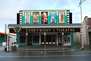
Everybody's Theatre in Tasman Street
|
|
| Country | New Zealand |
| Region | Taranaki Region |
| Territorial authority | South Taranaki District |
| Ward |
|
| Community | Taranaki Coastal Community |
| Electorates |
|
| Area | |
| • Urban | 3.78 km2 (1.46 sq mi) |
| Population
(June 2023)
|
|
| • Urban | 1,440 |
| • Urban density | 381.0/km2 (987/sq mi) |
| Postcode |
4616
|
Ōpunake is a small, friendly town on the southwest coast of Taranaki in New Zealand's North Island. It's about 45 kilometres southwest of New Plymouth. You can find it along State Highway 45. The town is home to around 1,440 (June 2023). people.
Contents
History of Ōpunake
Early History
In 1833, a local chief named Wiremu Kīngi Moki Te Matakātea showed great bravery. He used just one musket to defend his people against a large war party from Waikato. He managed to hold them off for several weeks and eventually won the battle. The place where this happened, Te Namu Pā, is on the coast just north of Ōpunake.
European Settlement
Europeans first settled in Ōpunake in the 1860s. British soldiers arrived in April 1865 during the Second Taranaki War. By May, they had built a fort called the Ōpunake Redoubt, where 350 soldiers were stationed.
In May 1867, the fort was given to Wiremu Kīngi Moki Te Matakātea's people. The area then became a place for flax mills, away from European control. British soldiers returned to the fort in 1875. It became a gathering point for soldiers during the invasion of Parihaka. Around 1887, the fort was no longer used. Ōpunake was planned to be a major port, but only a jetty was built in 1891.
Marae in Ōpunake
Ōpunake has two special meeting places called marae. These are important cultural centres for Māori people.
- Ōeo Marae and its meeting houses, Tipua Horonuku and Tipua Hororangi, belong to the Ngāruahine hapū (sub-tribe) of Ngāti Tamaahuroa me Tītahi.
- Ōrimupiko Marae and its meeting house, Ōhinetuhirau, are a meeting place for the Taranaki hapū of Ngāti Haumia, Ngāti Tamarongo, and Ngāti Kahumate.
In 2020, the government helped these marae by providing money to improve their driveways and paint their buildings. This also created 12 jobs for people in the community.
Pā Sites
Ōpunake is home to two historic pā sites. Pā are traditional Māori fortified villages.
- Te Namu Pā is located to the northwest, near the Otahi Stream and Te Namu Road.
- Another pā is found to the southeast, near Park Place and the Constabulary Cemetery by the lake.
The condition of these pā sites varies. Te Namu Pā is mostly still standing, though the old village and trenches are gone. Very little remains of the pā in the southeast.
History of Te Namu Pā
In 1833, Wiremu Kīngi Moki Te Matakātea led 120 men in a battle at Te Namu Pā. They fought against about 800 warriors from Waikato. The Waikato attack failed, and they eventually left. Those who were left behind were cremated in front of the pā.
Wiremu Kīngi Moki Te Matakātea and his men won the battle thanks to the land's natural features and their single musket. The only way to enter the pā was by following the Otahi stream along a narrow path behind it. The Waikato forces attacked the pā five times but could not capture it. Te Namu Pā is also sometimes called 'Kaiaia'.
The village at Te Namu Pā, built in 1833, was later destroyed by a landing party from a ship called HMS Alligator in 1834. Today, the site is considered a Urupa, which is a sacred burial ground.
Ōpunake's Population
Ōpunake covers an area of 3.78 km2 (1.46 sq mi). As of June 2023, it had an estimated population of 1,440. This means there are about 381 people living in each square kilometre.
| Historical population | ||
|---|---|---|
| Year | Pop. | ±% p.a. |
| 2006 | 1,365 | — |
| 2013 | 1,335 | −0.32% |
| 2018 | 1,401 | +0.97% |
At the 2018 New Zealand census, Ōpunake had 1,401 people. This was an increase of 66 people since the 2013 census. There were 570 households in the town.
The population included 681 males and 720 females. The average age was 44.2 years. About 20.1% of the people were under 15 years old.
Most people in Ōpunake are of European/Pākehā background (76.0%). A significant number are Māori (37.7%). There are also smaller groups of Pacific peoples and Asian people.
Things to See and Do
Ōpunake is a hub for the local dairy farming industry. It's also a popular place for tourists to visit.
The town has a beautiful beach made of black volcanic sand. At low tide, you can explore large rock pools on the north-west side of the beach.
The Ōpunake and nearby communities can use the South Taranaki District Council LibraryPlus. This place offers both library services and help with Council matters.
You can also see the Ōpunake murals on the main road. These artworks show the town's farming past, Māori culture, and modern history.
Education in Ōpunake
Ōpunake has several schools for students of different ages.
Opunake High School is a secondary school for students in years 9 to 13. It has about 248 students. The school celebrated its 75th birthday in 2000.
There are also three primary schools for younger students (years 1 to 8):
- Opunake School
- St Joseph's School, which is a state-integrated Catholic school.
- Te Kura Kaupapa Maori o Tamarongo, which is a Kura Kaupapa Māori school. This school teaches lessons in the Māori language.
Notable People from Ōpunake
Many well-known people have connections to Ōpunake:
- Jim Bolger (born 1935), a former Prime Minister of New Zealand.
- Carl Hayman (born 1979), a rugby union player who played as a prop.
- Graham Mourie (born 1952), a famous All Black captain.
- Samuel Russell Feaver (1878–1946), who was a farmer, pharmacist, and photographer.
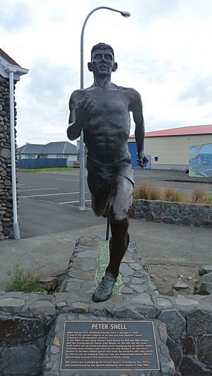
- Peter Snell (1938–2019), a world-famous middle-distance runner. A bronze statue of him was put up in Ōpunake in 2007.
- Jacquie Sturm (1927 – 2009), a talented poet, short story writer, and librarian.
 | Isaac Myers |
 | D. Hamilton Jackson |
 | A. Philip Randolph |


