Ordnance Survey buildings facts for kids
Quick facts for kids Ordnance Survey buildings |
|
|---|---|

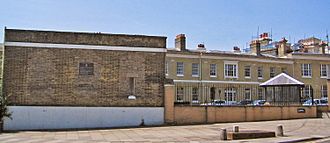
The former Ordnance Survey buildings in 2005
|
|
| Former names | Royal Military Asylum |
| General information | |
| Type | Yellow brick |
| Location | Southampton, England |
| Address | London Road |
| Coordinates | 50°54′47″N 1°24′12″W / 50.9131°N 1.4032°W |
| Construction started | 1866–1872 |
| Owner | HM Courts Service |
| Design and construction | |
| Architect | Major General Sir Henry James |
The old buildings where the Ordnance Survey used to work are in London Road, Southampton. Today, these buildings are part of the city's court system and are used by government groups. They are also special 'listed buildings', which means they are important and protected.
Contents
The History of Ordnance Survey Buildings
The Ordnance Survey first came to Southampton on November 12, 1841. This was just two weeks after a fire destroyed their main office in the Tower of London. They moved into empty buildings that had been built between 1794 and 1806. These buildings were first used as army barracks for the Duke of York's Royal Military School. Later, from 1816 to 1840, they became a branch of the Chelsea-based Royal Military Asylum. Some of the first barracks buildings were designed by a local architect named John Plaw.
The Royal Military Asylum
The asylum was a school for up to 400 military orphans and children of soldiers. It was open to both boys and girls until 1823. After that, the boys moved to Chelsea, and Southampton took in more girls. The school was named after Asylum Green, which is an open space in the middle of The Avenue. The number of students slowly went down, and the school closed in 1840.
Ordnance Survey Settles In
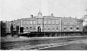
Even though the Ordnance Survey didn't really want to move to Southampton at first, they soon felt at home. Over the next 60 years, many new buildings were put up. Most of the original asylum and barracks buildings were taken down. The main building, built in the 1850s, had a tall clock tower. This tower became a well-known landmark in the town.
Moving On
In 1940, the buildings were badly damaged during the Blitz, which was a series of bombings. Because of this, the Ordnance Survey moved most of its work to temporary places. These temporary offices were in Chessington in Surrey and near Crabwood House in Maybush, on the edge of Southampton. By May 1969, almost all the staff had moved to a new, specially built main office in Maybush. This is when the Ordnance Survey left the London Road site for good.
Today, most of the old Victorian buildings have been removed. Newer buildings from the 1900s, like the printing building, are also gone. Most of the buildings that are left are used by different government groups. They work together with the modern court complex built on the northern part of the site. This includes the Crown Prosecution Service.
What the Buildings Look Like Now
The oldest building still standing is one of the engraving rooms. It was built shortly after the Ordnance Survey arrived in 1841. The other buildings that remain were built between 1866 and 1872. These include the barrack block, the staff quarters, and the Western Range. All of these were designed by Major General Sir Henry James. He was the Director-General of Ordnance Survey at the time. He designed the buildings to match Avenue House, where he lived from 1865 until he passed away.
All the remaining buildings on the site are special 'Grade II listed' buildings. They are built from yellow brick.
The Western Range
The biggest building is called the "Western Range." It's a long, two-story building with the year 1867 carved into a stone. It has two main parts that are slightly angled. This design helps it fit the curve of Carlton Crescent behind it and the slope of the land. The southern part has a central section that sticks out, with two wings. Each part has three windows on each floor. The northern part is a bit taller and has two halves.
The Barrack Block
Next to the Western Range is what is now known as the "Barrack Block." This is a single-story building with a flat roof. In the middle, there's a round archway for carriages. The windows on the London Road side have all been bricked up.
The Staff Quarters
At the southern end of the site is the old "Staff Quarters." This is a two-story building with four sections. It has seven windows on each level, though some are just blank spaces. The year 1868 is carved into one of the stones.
Other Buildings
There's also a square building with a sloped roof next to the modern court complex. It has three windows on each floor. The windows on the ground floor have special fan shapes that look like those on Avenue House. This building is all that's left of the original main building, which was badly damaged in the bombings and later taken down.
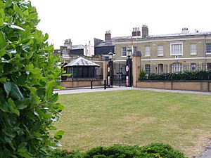
The entrance gates and the gate pillars are also special 'Grade II listed' items. They were made in the early 1800s. The gates are made of cast iron and are eight feet tall.
Avenue House
This large house is now known as the "Director General's House." It's on the corner of The Avenue and Rockstone Place. It was one of the last buildings designed by Samuel Toomer. The house was first rented to Thomas Leader Harman. He was a local politician and owned a weekly newspaper called the Hampshire Independent.
After Harman left in 1843, other people rented the house. Then, in 1865, the Ordnance Survey bought it. They renamed it "Ordnance House" so their Director-General could live there.
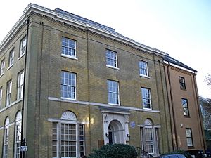
The house has three stories and is built of yellow brick. It has tall, flat columns at each corner. There are four windows on each floor on The Avenue side and three on the Rockstone Place side. The windows on the ground floor are round at the top. The main door is in the middle of the Rockstone Place side. Above the door, there's a stone frame with a rounded opening.
Today, the building is used as offices by a law firm. By the door, there's a blue plaque. This plaque remembers Major General Sir Henry James, who was the Director-General of the Ordnance Survey and lived there until he passed away in 1877. This building is also a 'Grade II listed' building.


