Osgood River facts for kids
Quick facts for kids Osgood River |
|
|---|---|

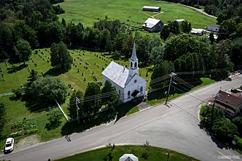
Kinnear's Mills Presbyterian Church and its cemeteries, along the river.
|
|
| Native name | Rivière Osgood |
| Country | Canada |
| Province | Quebec |
| Region | Chaudière-Appalaches |
| MRC | Les Appalaches Regional County Municipality |
| Physical characteristics | |
| Main source | Gagné River, ruisseau Prévost Kinnear's Mills 553 m (1,814 ft) 46°11′08″N 71°17′06″W / 46.185641°N 71.285035°W |
| River mouth | Palmer River Saint-Jacques-de-Leeds 206 m (676 ft) 46°17′52″N 71°22′39″W / 46.29778°N 71.3775°W |
| Length | 21.4 km (13.3 mi) |
| Basin features | |
| Progression | Palmer River, Bécancour River, St. Lawrence River |
| Tributaries |
|
The Osgood River (also called rivière Osgood in French) is a cool river in Quebec, Canada. It's like a smaller stream that flows into the Palmer River. The Palmer River then joins the Bécancour River, which eventually flows into the mighty St. Lawrence River. So, the Osgood River is part of a big river system!
This river flows through a few different areas in Quebec. These include parts of Kinnear's Mills and Inverness in the Centre-du-Québec region. It also passes through Saint-Jacques-de-Leeds in the Chaudière-Appalaches region.
Contents
Where the Osgood River Flows
The Osgood River starts in a small place called Plage-Lemieux, near Kinnear's Mills. It begins when two smaller streams, the Gagné River and the Prévost stream, meet up. This starting point is close to a road bridge.
The River's Journey
From where it begins, the Osgood River travels about 21.4 km (13.3 mi). That's like driving for about 15-20 minutes!
Here's how its journey goes:
- First, it flows about 6.1 kilometres (3.8 mi) northwest. It passes a bridge just southwest of Kinnear's Mills village.
- Then, it turns north and flows for about 4.6 kilometres (2.9 mi). It goes under the Route 216 bridge.
- It continues north for another 1.2 kilometres (0.75 mi), reaching the edge of the town of Inverness.
- For about 0.6 kilometres (0.37 mi), it crosses the eastern part of Inverness. Then it reaches the border of Saint-Jacques-de-Leeds.
- The river flows north for about 2.6 kilometres (1.6 mi), passing west of Saint-Jacques-de-Leeds village. Here, it meets the Sunday River.
- Finally, it travels another 1.2 kilometres (0.75 mi) north, crossing Route 271, until it reaches its end.
Where the River Ends
The Osgood River finishes its journey by flowing into the Palmer River. This happens in the town of Saint-Jacques-de-Leeds. Its meeting point with the Palmer River is about 1.6 kilometres (0.99 mi) upstream from the town's boundary.
How the Osgood River Got Its Name
The name "Osgood River" comes from a pioneer named Osgood. A pioneer is someone who was among the first to settle in a new area. This Osgood person settled along the river way back in the early 1800s! Sometimes, people used to spell the river's name "Osgoode."
The official name "Osgood River" was made formal on October 6, 1983. This was done by the Commission de toponymie du Québec, which is like a special group in Quebec that names places.
 | Jackie Robinson |
 | Jack Johnson |
 | Althea Gibson |
 | Arthur Ashe |
 | Muhammad Ali |

