Otford, New South Wales facts for kids
Quick facts for kids OtfordWollongong, New South Wales |
|||||||||||||||
|---|---|---|---|---|---|---|---|---|---|---|---|---|---|---|---|

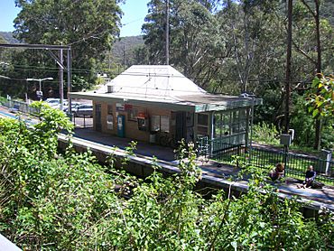
Otford railway station
|
|||||||||||||||
| Population | 369 (2016 census) | ||||||||||||||
| Postcode(s) | 2508 | ||||||||||||||
| Elevation | 172 m (564 ft) | ||||||||||||||
| Location |
|
||||||||||||||
| LGA(s) | City of Wollongong | ||||||||||||||
| State electorate(s) | Heathcote | ||||||||||||||
| Federal Division(s) | Cunningham | ||||||||||||||
|
|||||||||||||||
Otford is a small village located in the Otford Valley in New South Wales, Australia. It's about 55 km south of Sydney and 30 km north of Wollongong. Otford is part of the City of Wollongong local government area.
Contents
Exploring Otford's Location
Otford is nestled in the Otford Valley. It sits north of places like Stanwell Park and Stanwell Tops. To the east, you'll find a coastal ridge and a small community called Bulgo. Bulgo was also the original name for Otford!
West of Otford, on a flat area called a plateau, is the town of Helensburgh. To the north are Lilyvale and the famous Royal National Park.
Nature and Landscape
Otford is right at the southern edge of the Royal National Park. Its bushland is home to many native plants, like the beautiful Dendrobium Lilly. Most of the trees are dry Eucalypts. However, the valley slopes have tall open Eucalypt forests. You can also find rainforests along the creek and in the gullies.
The area is mostly made up of hillsides. The Hacking River flows through the valley towards the north. The highest points around Otford are over 250 metres above sea level. These are at Bulgo and Otford Hills. The Bulgo Range is a line of coastal hills. It's the northern part of the Illawarra escarpment, which slowly turns into steep coastal cliffs.
Local Attractions
Otford has a few fun places to visit. You can go horse riding at Otford Farm. There's also Govinda Valley and the Otford Pantry cafe. If you want amazing views, check out the Otford Lookout. It's on Lawrence Hargrave Drive and offers similar views south over the Illawarra region as Bald Hill.
Otford's Past: A Brief History
Otford was first known as Bulgo. This name appeared on a map in 1842 by Robert Dixon. It was used for quite some time.
The Railway Era
In 1885, a village started to form when the Illawarra railway line was being built. It began with just four houses. The name was officially changed to Otford in May 1885. That same year, the village grew. The first school and a post office were built. By 1887, Otford had a hotel, a butcher's shop, a bakery, a tailor, a jeweller, and a general store. There was even a billiard room and a skittle alley!
After the railway construction finished, the village became quieter. The school even closed in 1893. Trains would stop at Otford to get water. A small railway and sawmill area grew near the tunnel entrance.
Timber and Mushrooms
A timber mill was set up in 1875 by Thomas Gergos and his three brothers. It was located at Karingal, in the north of the Otford valley. Later, in 1899, James Forster built another mill to the south.
In 1952, Lilyvale Mushrooms Pty. Ltd started growing mushrooms in a small tunnel near Lilyvale. By 1959, they were using two tunnels for their mushroom farm.
New Tunnels and Old Ones
The current railway tunnel between Otford and Stanwell Park was built in 1917. The old tunnel had problems like smoke building up and a very steep slope. The railway projects in this area are known as amazing engineering achievements. The views from the railway are also very famous. The original, abandoned railway tunnel was used for a mushroom farm for a while, but it's not used anymore.
Over time, the village shops and the post office all closed down. Today, a cafe with limited hours remains on Lady Wakehurst Drive. It mostly serves tourists.
Otford is part of the old Parish of Bulgo. It used to be in the Bulli Shire Council area, which later became part of the Wollongong City Council.
Important Heritage Sites
Otford has a few places that are protected for their historical importance. These are called heritage-listed sites. One important site is:
- Illawarra railway: Otford railway tunnel
Who Lives in Otford?
In the 2016 Census, there were 369 people living in Otford. Most people, about 79.8%, were born in Australia. Also, 83.3% of people spoke only English at home. When asked about religion, the most common answer was "No Religion," at 51.1%.
Community Services
Otford has fewer services now than it used to, but it still has some important ones:
- A public primary school
- A railway station on the NSW TrainLink South Coast Line
- A volunteer Rural Fire Brigade
- The Otford Community Hall
- A tennis court and playground
- A cafe
The Otford railway station used to have beautiful gardens. Now, it's a more modern concrete and brick stop for commuters. Many bushwalkers use the station to get into the Royal National Park.
One of the most important parts of Otford's community is its Bushfire Brigade. All the members are volunteers from the village. They work hard to protect the town and the surrounding area from serious bushfires. It's a very important part of local life. The local school is another key community hub for this small, family-focused Australian village. The school has been open again for many years.
 | Jackie Robinson |
 | Jack Johnson |
 | Althea Gibson |
 | Arthur Ashe |
 | Muhammad Ali |


