
Oyster Bay Regional Shoreline facts for kids
Quick facts for kids Oyster Bay Regional Shoreline |
|
|---|---|
| Type | Regional Shoreline |
| Location | Alameda County, California |
| Nearest city | San Leandro, California |
| Area | 157 acres (0.64 km2) |
| Created | 1980 |
| Operated by | East Bay Regional Park District |
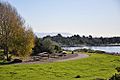
Oyster Bay Regional Shoreline is a fun park in San Leandro, California. It's managed by the East Bay Regional Park District (EBRPD). You can find it along the eastern edge of San Francisco Bay. It's right next to the Oakland International Airport. This area used to be a landfill for 37 years. It was closed in 1977 and then covered with a special clay layer. The EBRPD bought the land in 1980, planning to turn it into a park for everyone to enjoy.
The Park's Story: From Landfill to Fun
The land that is now Oyster Bay Regional Shoreline was once a landfill. This means it was a place where trash was buried. The landfill closed in 1977. In the early 1980s, the EBRPD bought the site. They wanted to create a park there someday.
Since then, the park district has worked hard to make the land safe. They brought in clean soil to cover the old landfill. This helps make sure the ground is safe and drains water properly. It also helps keep the environment healthy.
The EBRPD has allowed some activities while working on the park. You can walk dogs, hike, and have picnics there. They are also planning new fun areas. These include a disc golf course and a special area for bicycle skills. They also plan to add more parking.
In 2013, the EBRPD directors approved a plan for the park. This plan helps guide how the park will grow. It includes new ways to enter the park and more parking. It also plans for better trails and managing natural resources. The plan also covers the bike skills area, disc golf course, and a special off-leash dog area.
Exploring Oyster Bay Regional Shoreline
The main way to enter the park used to be from Neptune Boulevard. This road is off Marina Boulevard. As of 2014, the EBRPD started building a second entrance. This new entrance is on Davis Street.
Inside the park, you'll find seven picnic areas. You can't reserve these, so they are available first-come, first-served. The park has many trails for different activities. These trails lead to a special viewing spot in the middle of the park. This spot has a cool sculpture called "Rising Wave."
The San Francisco Bay Trail runs through the park. This part of the trail is paved and is about 2 miles (3.2 km) long. It goes from the Neptune Drive entrance to the Bill Lockyer bridge. If you have a dog, they can walk on paved trails. But, unleashed dogs are only allowed on unpaved trails.
There's also a trail called the Oyster Bay Regional Shoreline Loop. This trail is about 4.6 miles (7.4 km) long. It's great for all skill levels, whether you're a beginner or an experienced hiker. Plus, there's a water fountain along the trail. It's even designed so dogs can get a drink too!
Images for kids
-
San Leandro Oyster Bay Homes

