Pagham Harbour facts for kids
| Site of Special Scientific Interest | |
 |
|
| Area of Search | West Sussex |
|---|---|
| Interest | Biological Geological |
| Area | 629.0 hectares (1,554 acres) |
| Notification | 1986 |
| Location map | Magic Map |
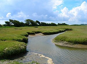
Pagham Harbour is a very special natural area located near Bognor Regis in West Sussex, England. It covers a huge space of about 629 hectares, which is like 1,554 football fields! This amazing place is mostly made up of saltmarsh and calm, shallow lagoons.
Unlike many harbours, Pagham Harbour isn't an estuary because no big rivers flow into it. Instead, only a few small streams from the surrounding fields bring freshwater into the area. This unique setup creates a perfect home for many different kinds of plants and animals.
Pagham Harbour is recognized as a Site of Special Scientific Interest (SSSI) because of its important wildlife and interesting geology. It's also a Ramsar site, which means it's a wetland that is important all over the world, especially for birds. On top of that, it's a Special Protection Area and a Marine Conservation Zone, showing how much effort goes into protecting its natural beauty. A large part of the harbour, about 599 hectares, is also a Local Nature Reserve, making it a wonderful place for people to visit and learn about nature.
A Look Back: Pagham Harbour's Past
Pagham Harbour has a long and interesting history. Long ago, it was a busy working harbour with three different ports!
The Old Ports
One port, called Wardur, was located at the western end of the harbour, close to Sidlesham Mill. Another port, named Charlton, was right at the entrance to the harbour. The third port was on the Pagham side and was known as the Port of Wythering (or Wyderinges).
The port of Wardur was part of a new development called 'New Haven' during the Middle Ages. However, the Port of Wythering was taken over by the sea in the 1200s. Eventually, the entire harbour became filled with silt, making it too shallow for most boats to use, except for very small ones.
A Failed Farming Project
Around 1873, people tried to drain the harbour so they could use the land for farming. They built a large wall, called an embankment, across the edge of the lagoon to keep the sea out. But this plan didn't work out. A big storm in December 1910 broke through the embankment, and it was never rebuilt.
Today, the entrance to the sea is about 50 metres wide, allowing the tides to flow in and out, keeping the saltmarsh and lagoons as they are.
 | Selma Burke |
 | Pauline Powell Burns |
 | Frederick J. Brown |
 | Robert Blackburn |

