
Palestine, Arkansas facts for kids
Quick facts for kids
Palestine, Arkansas
|
|
|---|---|
 |
|

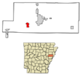
Location of Palestine in St. Francis County, Arkansas.
|
|
| Country | United States |
| State | Arkansas |
| County | St. Francis |
| Area | |
| • Total | 3.33 sq mi (8.62 km2) |
| • Land | 3.31 sq mi (8.56 km2) |
| • Water | 0.02 sq mi (0.06 km2) |
| Elevation | 213 ft (65 m) |
| Population
(2020)
|
|
| • Total | 506 |
| • Density | 153.10/sq mi (59.11/km2) |
| Time zone | UTC-6 (Central (CST)) |
| • Summer (DST) | UTC-5 (CDT) |
| FIPS code | 05-53150 |
| GNIS feature ID | 2404462 |
Palestine is a small town located in St. Francis County, Arkansas, in the United States. It sits right next to the L'Anguille River. In 2020, about 506 people lived there.
Contents
Where is Palestine Located?
Palestine covers a total area of about 3.3 square miles (8.6 square kilometers). Most of this area is land, with a very small part being water.
Who Lives in Palestine?
| Historical population | |||
|---|---|---|---|
| Census | Pop. | %± | |
| 1890 | 163 | — | |
| 1900 | 196 | 20.2% | |
| 1910 | 173 | −11.7% | |
| 1920 | 297 | 71.7% | |
| 1930 | 209 | −29.6% | |
| 1940 | 345 | 65.1% | |
| 1950 | 420 | 21.7% | |
| 1960 | 532 | 26.7% | |
| 1970 | 755 | 41.9% | |
| 1980 | 976 | 29.3% | |
| 1990 | 711 | −27.2% | |
| 2000 | 741 | 4.2% | |
| 2010 | 681 | −8.1% | |
| 2020 | 506 | −25.7% | |
| U.S. Decennial Census | |||
In 2000, about 741 people lived in Palestine. There were 299 households, which are groups of people living together. Many of these were families.
The people living in Palestine come from different backgrounds. Most residents were White, and a smaller number were Black or African American. There were also people from other racial groups.
The town has people of all ages. About 26.7% of the population was under 18 years old. About 14.2% of the people were 65 years or older. The average age in Palestine was 36 years.
Education in Palestine
Students in Palestine attend public schools through the Palestine–Wheatley School District. This district helps students from elementary school all the way through high school. Students graduate from Palestine–Wheatley High School. The school district was created in 1987 when the Palestine School District and the Wheatley School District joined together.
Images for kids
-
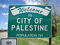
A view of Palestine, Arkansas.
-
Map showing Palestine's location in St. Francis County.
See also
 In Spanish: Palestine (Arkansas) para niños
