L'Anguille River facts for kids
Quick facts for kids L'Anguille River |
|
|---|---|

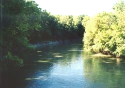
The L'Anguille River at Palestine, Arkansas
|
|
| Country | United States |
| State | Arkansas |
| Physical characteristics | |
| Main source | Craighead County, Arkansas 245 ft (75 m) 35°39′33″N 90°43′33″W / 35.65917°N 90.72583°W |
| River mouth | St. Francis River 161 ft (49 m) 34°43′14″N 90°40′14″W / 34.72056°N 90.67056°W |
| Length | 110 mi (180 km) |
The L'Anguille River is a river in northeastern Arkansas, United States. It is about 110 miles (175 km) long. This river flows into the St. Francis River. From there, its waters eventually join the mighty Mississippi River.
The name "L'Anguille" comes from the French language. It means "the eel". This suggests that eels might have been common in the river long ago.
The River's Journey
The L'Anguille River begins south of Jonesboro. It forms in southern Craighead County from several farm ditches. Parts of the river's upper section have been straightened. This process is called channelization. It helps water flow faster, often for farming.
Flowing South Through Arkansas
The river generally flows south. It travels through several counties in Arkansas. These include Poinsett, Cross, St. Francis, and Lee Counties.
The L'Anguille River flows alongside a landform called Crowley's Ridge. It also passes by towns like Palestine and Marianna.
Where the River Ends
The L'Anguille River joins the St. Francis River in eastern Lee County. This meeting point is not far from where the St. Francis River itself flows into the Mississippi River. There is also a special ditch that sends some water from the St. Francis River into the lower part of the L'Anguille.
 | William M. Jackson |
 | Juan E. Gilbert |
 | Neil deGrasse Tyson |

