Papatoetoe railway station facts for kids
Quick facts for kids
Papatoetoe
|
|||||||||||||||
|---|---|---|---|---|---|---|---|---|---|---|---|---|---|---|---|
| Auckland Transport Urban rail | |||||||||||||||

Papatoetoe Train Station
|
|||||||||||||||
| Location | Station and Shirley Roads, Papatoetoe | ||||||||||||||
| Coordinates | 36°58′42″S 174°50′59″E / 36.9782°S 174.8498°E | ||||||||||||||
| Owned by | KiwiRail (track and platforms) Auckland Transport (buildings) |
||||||||||||||
| Line(s) | Eastern Line, Southern Line | ||||||||||||||
| Platforms | Island platform | ||||||||||||||
| Tracks | Mainline (2) | ||||||||||||||
| Construction | |||||||||||||||
| Parking | Yes | ||||||||||||||
| Bicycle facilities | Yes | ||||||||||||||
| Other information | |||||||||||||||
| Fare zone | Manukau North | ||||||||||||||
| History | |||||||||||||||
| Opened | 1875 | ||||||||||||||
| Rebuilt | 2006 | ||||||||||||||
| Electrified | 25 kV AC | ||||||||||||||
| Traffic | |||||||||||||||
| Passengers (2011) | 3,074 passengers/weekday | ||||||||||||||
| Services | |||||||||||||||
|
|||||||||||||||
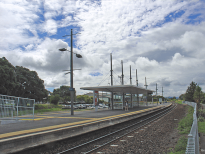
The Papatoetoe railway station is an important train stop in Auckland, New Zealand. It is part of Auckland's train network, serving both the Southern and Eastern train lines. You can find it between Station Road and Shirley Road in Papatoetoe. The station has an island platform, which means the train tracks are on both sides of the platform.
Contents
History of Papatoetoe Station
The Papatoetoe station has a long and interesting history. It first opened way back in 1875!
What's in a Name?
When the station first opened, it was actually called "Papatoitoi." This was a slightly different spelling from the town it served, which was always "Papatoetoe." To fix this, the New Zealand Railways Department officially changed the station's name to Papatoetoe in 1907.
The Old Station Building
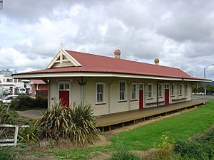
The original station building is quite old, with some parts dating back to 1875. It's a special part of the area's history. Instead of being torn down, this old building was carefully moved. Now, it's been given a new life as a cafe! You can find it at the corner of Station Road, Shirley Road, Tavern Lane, and St George Street. A brand new station was built where the old one used to be.
Key Moments in Time
- 1875: The train line reached Papatoetoe. The very first station, called Papatoitoi Station, was built.
- 1887: For a while, the station became a "flag station." This meant trains only stopped if someone waved a flag to show they wanted to get on or off!
- 1907: The station's name was officially changed to Papatoetoe.
- 1914: The station got bigger with two new rooms, and a stationmaster was put in charge again.
- 1919: After being moved again, the station reopened. It even had a large windmill and a huge water tank! These helped provide water for the station and for the steam locomotives.
- 1942: The windmill and water tower were removed because the station was connected to the town's water supply.
- 2006: The station was rebuilt to be more modern and better for passengers.
Train and Bus Services
Today, Transdev Auckland, working for Auckland Transport, runs the train services at Papatoetoe station. You can catch trains to several places from here.
Train Routes
During typical weekdays, you can expect trains to:
- Britomart: About six trains per hour go to Britomart. Some go via Glen Innes (Eastern Line), and others go via Penrose and Newmarket (Southern Line).
- Manukau: About three trains per hour head to Manukau.
- Papakura: About three trains per hour go to Papakura.
Bus Connections
Several bus routes also stop at Papatoetoe station, making it easy to connect to other parts of the city. These include the AirportLink, Route 31, and Route 313.
 | Bessie Coleman |
 | Spann Watson |
 | Jill E. Brown |
 | Sherman W. White |


