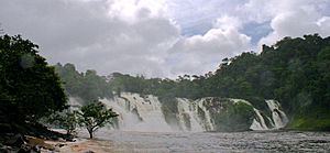
Pará Falls facts for kids
Quick facts for kids Pará Falls |
|
|---|---|
 |
|
| Lua error in Module:Infobox_mapframe at line 185: attempt to index field 'wikibase' (a nil value). | |
| Location | Bolívar, Venezuela |
| Coordinates | 06°18′40″N 64°31′26″W / 6.31111°N 64.52389°W |
| Type | Segmented |
| Total height | 64 m (210 ft) |
| Average width | 5,608 m (18,399 ft) |
| Watercourse | Caura River |
| Average flow rate |
3,540 m3/s (125,000 cu ft/s) |
The Pará Falls (also called Salto Pará) are a series of huge waterfalls on the Caura River in Bolívar, Venezuela. These powerful falls are a breathtaking natural wonder and play an important role in the local environment and culture.
Pará Falls: A Natural Wonder
The Pará Falls are located about 210 kilometers (130 miles) upstream from where the Caura River meets the large Orinoco River. They are so big that they create a natural dividing line between the upper and lower parts of the Caura River.
Because it's very hard to travel past the Pará Falls by boat, they have traditionally been a natural boundary for local groups. These include the Ye'kuana and Kalina tribes.
Exploring the Falls
The first European to describe the Pará Falls was a French explorer named Eugène André. He wrote about them during his trip along the Caura River in 1900. In an article for The Geographical Journal, he explained how the falls create a huge barrier to boats.
He noted that just above the falls, the river splits into two streams. These streams flow around a large island, which is about 7 to 9 miles long. The two streams then rush through narrow canyons on both sides of the island. They meet again at the bottom of the island. André observed that the stream on the right side carries much more water than the one on the left. Sometimes, after a long dry period, the left stream can almost completely dry up.
In 1976, a power company called CADAFE looked at the Pará Falls as a possible place to build a hydroelectric power plant. This kind of plant uses the force of falling water to create electricity. However, these plans were later stopped because the ground in the area wasn't suitable for building such a large structure.
Reaching Pará Falls
Since there are no roads in the area around the Pará Falls, the easiest way to visit them is by boat. This makes the journey to the falls an adventure in itself, allowing visitors to experience the wild beauty of the Caura River.
See also
 In Spanish: Salto Pará para niños
 | Dorothy Vaughan |
 | Charles Henry Turner |
 | Hildrus Poindexter |
 | Henry Cecil McBay |

